SONORO GOLD REPORTS UNDERGROUND CHANNEL SAMPLING PROGRAM AT CERRO CALICHE INCLUDING 2.0 METERS OF 7.863 GRAMS OF GOLD PER TONNE
VANCOUVER, Canada, Aug. 15, 2022 (GLOBE NEWSWIRE) — Sonoro Gold Corp. (TSXV: SGO | OTCQB: SMOFF | FRA: 23SP) (“Sonoro” or the “Company”) is pleased to report results from an underground channel sampling program recently completed at its Cerro Caliche gold project in Sonora, Mexico. The program was conducted as part of the Company’s plan to develop a proposed heap leach mining operation as outlined in an updated Preliminary Economic Assessment dated June 23, 2022.
Figure 1: Channel sampling at south end of Cabeza Blanca
Samples were obtained from a historic underground tunnel at the Cabeza Blanca mineralized gold zone, located in the southwestern part of the property.
An electric rotary handheld saw was used to acquire 34 quality continuous channel samples of vein and breccia material. Saw cuts were approximately four to six centimeters (cm) deep cut perpendicular to the vein trend.
Highlights include 2.0 meters averaging 7.863 grams of gold per tonne (“g/t Au”) across the vein with 3.5 meters averaging 3.071 g/t Au over the five saw cuts along the vein segment.
All reported intervals are true measured widths and all material was surface oxidized with the deepest samples collected approximately 25 to 30 meters beneath the terrain surface.
Results provide important geological data from a 100-meter section situated along the south end of the Cabeza Blanca vein zone as it enters the El Colorado mineralized zone.
The current resource estimate classified this 100-meter section as an inferred resource, but the underground sampling results, together with over 7,200 meters of new drilling data, will be included in an updated resource calculation being completed on the project.
Mel Herdrick, Sonoro’s VP Exploration, commented, “The data is a good example of continuity of gold mineralization which is coincident with the normal vertical and lateral variations we see when drilling.This detailed programalso provided quality and unbiased sampling of the vein and part of the exposed mineralized wall allowinga more complete evaluation of gold mineralized volumes in this area.“
Kenneth MacLeod, Sonoro’s President and CEO, noted, “The underground channel sampling yielded valuable data that we anticipate will augment the data obtained from our recent surface sampling and drilling programs completed in the same area. As previously announced, an updated resource estimate is being prepared and will incorporate all geological data to date.”
John Darch, Sonoro’s Chairman, added, “The positive results from the Cabeza Blanca South tunnel sampling program continue to highlight the intrinsic value of the project and underline theBoard’s ongoing commitment to develop the proposed heap leach mining operation at Cerro Caliche.“
Tunnel Sampling Results
The Cabeza Blanca vein zone has average mineralized widths of up to 29 meters, inclusive of footwall and hanging wall mineralization. Two historic tunnels were developed in the 1950s along the Cabeza Blanca vein, with the northern tunnel continuing approximately 600 meters on a 10 northwestern trend and the southern tunnel continuing approximately 350 meters on a 15 southeastern trend to the El Colorado zone. The southern tunnel splays into two distinct tunnels at the midway point and the sampling program was completed in the eastern splay. The western splay was not sampled.
As illustrated in the image below, sampling occurred in three segments across 90 meters of the tunnel. Segment No. 1 is the southernmost and nearest to the mouth of the tunnel, Segment No. 2 is located about midway and Segment 3 is a raised area at the north end of the tunnel.
Figure 2:Underground tunnel segments and sample cuts
Samples from Segment No. 1 returned the lowest gold grades with the five sample cuts averaging 3.9 meters of 0.401 g/t Au.
Segment No. 2 returned the highest gold grades ranging from 0.624 g/t Au to 7.863 g/t Au, with the five sample cuts averaging 3.5 meters of 3.071 g/t Au. The highest assay value of 7.863 g/t Au was across two meters from a vein-perpendicular saw cut with continuation in the vein hanging wall, including two additional samples with veinlets and a composite 4.6 meters at 4.93 g/t Au.
Segment No. 3 returned gold grades ranging from 0.704 g/t Au to 4.086 g/t Au, with the five sample cuts averaging 1.86 meters of 1.789 g/t Au.
The samples agree with the longitudinal contoured mineralization projections of the zone. A longitudinal plot of the drill intercepts with greater than 0.15 g/t Au is shown below.
Figure 3: Longitudinal section illustrating contoured values
The widths of the intercepts from the drill holes are plotted where the vein is cut and values contoured. This illustrates a near horizontal continuity of mineralization across the length of the Cabeza Blanca vein zone. The near horizontal character of contoured gold intercept values may reflect original boiling horizons as the ground water levels may have varied. This is also supported by the presence of historic workings which were developed in higher grade contoured areas of the vein.
Quality Assurance/Quality Control (“QA/QC“) Measures and Analytical Procedures
Channel samples were generated with an electric rotary handheld saw and chisel, and collected by hand in a catchment tarp below. The bagged samples were numbered and identified, and the site photographed after painting sample numbers on the ceiling. The samples were transported directly to the Bureau Veritis preparation laboratory in Hermosillo, Sonora. At the laboratory, part of each sample is reduced through crushing, splitting and pulverization from which 200 grams is sent to the B.V. gold assay laboratory in Hermosillo. A portion weighing 30 grams undergoes fire assay for gold, with the resulting concentrated button of material produced then dissolved in acids and the gold is determined by atomic absorption. The remaining sample pulp material is sealed in paper bags and retained for additional analysis.
No QA/QC issues were noted with the results received from the laboratory.
Geologic Description
Cerro Caliche is located 45 kilometers east southeast of Magdalena de Kino in the Cucurpe-Sonora Mega-district of Sonora, Mexico. Multiple historic underground mines were developed in the concession, including Cabeza Blanca, Los Cuervos, Japoneses, Las Abejas, Boluditos, El Colorado, Veta de Oro and Espanola. Mineralization types of the Cucurpe-Sonora Mega-district include variants of epithermal low sulfidation veins and related mineralized dikes and associated volcanic domes. Local altered and mineralized felsic dikes cut the mineralized meta-sedimentary rock units and may be associated with mineralization both in the dikes and meta-sedimentary rocks.
Qualified Person Statement
Stephen Kenwood, P.Geo., a Director of Sonoro, is a Qualified Person within the context of National Instrument 43-101 (NI 43-101) and has read and approved this news release. Readers are cautioned that the presence of mineralization on historic mines adjacent to or on Cerro Caliche is not necessarily indicative of economic gold mineralization in the concessions held by the Company.
About Sonoro Gold Corp.
Sonoro Gold Corp. is a publicly listed exploration and development Company holding the near-development-stage Cerro Caliche project and the exploration-stage San Marcial project in Sonora State, Mexico. The Company has highly experienced operational and management teams with proven track records for the discovery and development of natural resource deposits.
On behalf of the Board of Sonoro Gold Corp.
Per: “Kenneth MacLeod“
Kenneth MacLeod
President & CEO
For further information, please contact:
Sonoro Gold Corp. – Tel: (604) 632-1764
Email: info@sonorogold.com
- Published in News Home, Sonoro Gold
SONORO GOLD COMPLETES PHASE IV DRILLING PROGRAM AT CERRO CALICHE REPORTS MULTIPLE HIGHER-GRADE INTERCEPTS & EXPANSION OF GOLD MINERALIZED ZONES
Sonoro Gold Corp. (TSXV: SGO | OTCQB: SMOFF | FRA: 23SP) (“Sonoro” or the “Company”) is pleased to report assay results from the final seven drill holes, completing the Phase IV drilling program at its Cerro Caliche gold project in Sonora, Mexico. In total, the Company completed over 7,200 meters of reverse circulation drilling with 63 drill holes which returned multiple higher-grade gold intercepts and demonstrated the expansion of several known mineralized gold zones within the Cerro Caliche concession.
The objective of the program was to increase the estimated size and grade of the project’s oxide gold mineralization, as well as to extend the estimated life of a proposed heap leach mining operation as outlined in the Preliminary Economic Assessment (“PEA”) and updated Mineral Resource Estimate filed under the Company’s profile on SEDAR on October 29, 2021.
On May 9, 2022, the Company announced positive results of an updated PEA based on an optimized mine plan to potentially increase the project’s previously reported economic parameters. The updated report was based on the same mineral resource estimate contained in the Company’s initial PEA and did not include the new geological data from the Phase IV campaign.
Drilling results from the now completed Phase IV campaign will be included in an updated resource estimation scheduled to be announced in the fall of 2022. The economic impact of the updated resource on the proposed heap leach mining operation is also to be assessed and will be contemplated in a further technical report.
Mel Herdrick, Sonoro’s VP Exploration, commented, “Phase four has been a successful drilling campaign with continued reporting of mineralized extensions and higher-grade intercepts.As the project continues to move through the current permitting phase, the objective of the exploration team now is to refine our understanding of the new extensions and higher-grade zones, as well as the potential impact of the new drilling data on the project’s resource.”
Kenneth MacLeod, Sonoro’s President and CEO, added, “The completion of the drilling program is another important milestone in the development of Cerro Caliche. Last month we announced the positive results of an updated PEA and are currently assessing the potential economic impact of the new drilling data on the proposed heap leach mining operation. An updated resource estimation is expected to be filed this fall and we will continue to work on securing project financing and moving the project forward.”
John Darch, Sonoro’s Chairman, noted, “With regards to the successful completion of the drilling program, the Board would like to specifically commend the efforts of our exploration team in Mexico, most notably VP of Exploration Mel Herdrick, VP of Operations Jorge Diaz and Chief Geologist Oscar Gonzalez.These individuals have been instrumental in the success of Cerro Caliche’s exploration and development programs.”
Final Drilling Results
The results announced in this news release reflect drilling activity conducted at the Abejas gold mineralized zone located at the eastern perimeter of the Central Pit Zone, with the reported intercepts situated outside of the pit shell used to calculate the mineral resource estimate in the initial PEA.
Highlights are as follows:
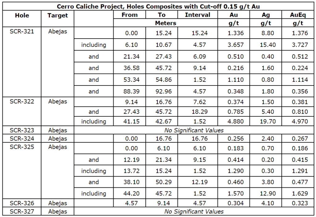
- SCR-321 intercepted 15.24m averaging 1.336 g/t Au; including 4.57m averaging 3.657 g/t Au;
- SCR-322 intercepted 18.29m averaging 0.785 g/t Au; including 1.52m averaging 4.88 g/t Au.
The map below illustrates the location of the drill holes.
Figure 1: Drill holes at Abejas
AbejasMineralizedZone
The Abejas zone is in the most eastern part of the property’s main body of gold mineralization where seven drill holes demonstrated an approximate 30-meter southernly extension outside of the estimated resource pit shell. Three of the seven drill holes also returned higher-grade intercepts, including drill hole SCR-321 which intercepted 15.24 meters averaging 1.336 grams of gold per tonne (“g/t Au”), including 4.57 meters averaging 3.657 g/t Au and drill hole SCR-322 which intercepted 18.29 meters averaging 0.785 g/t Au, including 1.52 meters averaging 4.880 g/t Au.
The Abejas extension is terminated by a northeasterly trending fault that continues southwesterly to offset the Los Cuervos mineralization. Further detailed work around the faulted Abejas zone could determine the same relationship with possible additional targets.
Both drill holes SCR-321 and SCR-322 correlate with other plotted vein projections intersected further north and the geology of the Abejas zone is similar to the Japoneses gold mineralized zone with most rock drilled being Jurassic-Cretaceous metasedimentary quartzite, shale and local limestone beds. Structures with quartz vein fillings cross with the normal northwest orientation and are part of the wider zone of sheeted gold mineralized veins.
The Abejas zone is about 600 meters long and is traced further northwesterly to join the Veta del Oro zone which has a long, well-defined vein zone with higher gold and silver grades. Anomalous silver content is also present in the results with 24.9 grams per tonne intercepted in drill-hole SCR-321 between depths of 9.14 and 10.67 meters. Lead is also anomalous with gold but in broader anomalies. Silicification is common in the area, especially close to the vein zones.
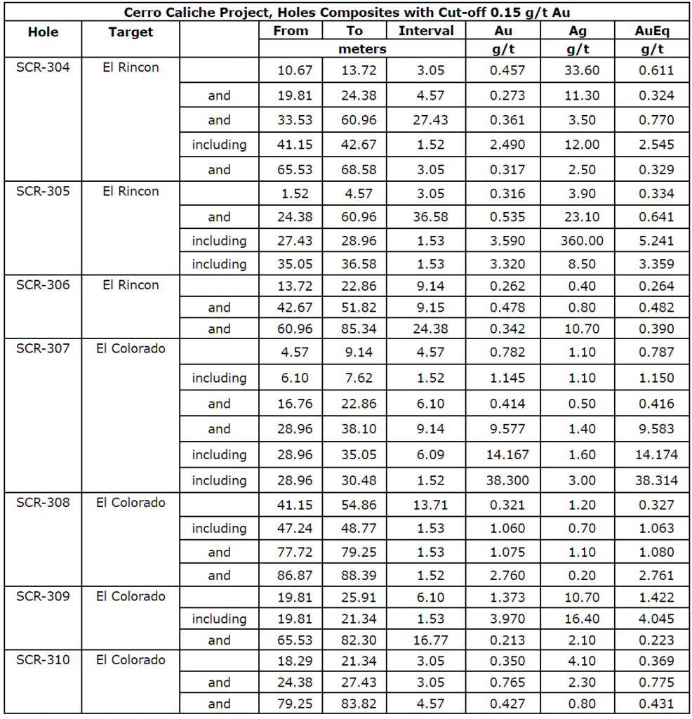
The table below provides the assay results for the complete list of reported drill holes. Vein intersections appear to be near true widths reported from assay intervals. Drill holes cross the veins with 45-degree inclination, while veins appear to have dips around 50 to 60 degrees.
Drill collar locations, azimuths and dips for the drill holes included are provided in the table below.

Phase IV Drilling Program
In November 2021, the Company announced it had resumed drilling with the objective of increasing the estimated size and grade of the project’s oxide gold mineralization. An independent PEA completed on the Cerro Caliche project demonstrated a potentially viable seven-year open pit, heap leach mining operation with a production capacity of up to 15,000 tonnes per day. An increase in the size and grade of the project’s resource may not only extend the life of the proposed operation but may also improve the overall economics of the project.
The Phase IV drilling program was designed to potentially expand known mineralized zones, including zones excluded from the mineral resource estimate due to lack of required drilling density. The program also drilled potential higher-grade targets identified by a surface sampling program completed in the summer of 2021.
The map below illustrates the location of drill holes completed during the Phase IV drilling program.
Figure 2: Drill holes at Cerro Caliche
El ColoradoMineralized Gold Zone
Drilling completed at El Colorado provided the Company with an improved structural understanding of the complexity of the mineralized zone, including higher-grade blind (lack of surface exposure) structures or shoots. While the zone is complexly faulted and veined, the additional drill holes completed during the Phase IV program began to reveal coherent high-grade gold bearing veins, as well as anastomosing veins diverging and branching from zone’s main veins.
Collectively, these suggest an increased potential for a higher-grade open pit which, if confirmed, may also potentially increase the average gold content of the entire mineralized zone.
As previously announced, drilling completed at El Colorado returned multiple higher-grade gold intercepts within larger intervals of high-grade gold mineralization including drill hole SCR-286 which intercepted high-grade gold mineralization at the deepest level of El Colorado’s epithermal system drilled to date.
Near the bottom of the hole, a 27.43-meter intercept averaged 5.36 g/t Au, including 4.57 meters averaging 7.16 g/t Au, and 4.57 meters of 22.09 g/t Au, including 1.53 meters averaging 46.5 g/t Au and 1.52 meters averaging 3.25 g/t Au.
Figure 3: Interpretive Cross Section at El Colorado
A total of 20 additional drill holes were completed outside of the estimated resource pit shell used to calculate the zone’s gold resource. As previously announced, five drill holes demonstrated an expansion of approximately 30 meters along the northwestern side of the estimated resource pit shell.
Oxidized mineralized material is present throughout El Colorado with no significant sulfide minerals present. The geology is a mixture of silicified meta-sedimentary units intruded by a silicified and argillic altered quartz porphyry igneous body and, in deeper parts, granodiorite with dioritic to andesitic dikes. The mineralized structures trending north 10 west and dipping northeasterly cross the zone extending southerly from the Cabeza Blanca quartz veins.
Guadalupe Mineralized Gold Zone
Located to the north of El Colorado, and parallel to the Cabeza Blanca mineralized gold zone, Guadalupe was excluded from the updated mineral resource estimate due to its lack of sufficient drilling density.
Drilling completed at Guadalupe during Phase IV returned intercepts of higher-grade gold vein material at depth, including previously announced drill hole SCR-280 which intercepted 3.05 meters averaging 19.56 g/t Au, including 1.53 meters averaging 37.90 g/t Au. The higher-grade zone’s repetitive character likely is due to a higher degree of shearing at the footwall of the Guadalupe vein structure.
Figure 4: Drill holes at El Rincon
The footwall shows stronger shear character, including mylonitic vein textures locally, and suggests the potential for development and further exploration in areas to the west where numerous veins are present. Guadalupe’s entire structural zone may be permissive over more than 100 meters width.
Buena Suerte Mineralized Gold Zone
Buena Suerte is approximately 300 meters east of El Colorado and drilling completed during Phase IV extended the Buena Suerte vein system to the southwest and potentially increased the zone’s estimated resource. Mineralization was shown to extend further south another 500 meters, but additional drilling is required to follow the vein zones located beneath a cover of thick soils and colluvium.
As previously reported, drill hole SCR-318 returned elevated gold content of 1.52 meters averaging 9.57 g/t Au and 28.95 meters averaging 1.021 g/t Au, including 1.53 meters averaging 2.07 g/t Au. The potential of the mineralization connecting to other high grade drill intercepts further north requires additional investigation.
El Rincon Mineralized Gold Zone
Drilling completed between two separate pit shells at El Rincon confirmed continuation of mineralization between the resource segments along a rhyolitic dike. A total of 6 drill holes were completed during the Phase IV campaign over approximately one kilometer of strike length. As previously announced, SCR-304 intercepted 1.52 meters averaging 2.49 g/t Au and drill hole SCR-305 intercepted 36.5 meters averaging 0.535 g/t Au, including 1.53 meters averaging 3.59 g/t Au and 1.53 meters averaging 3.32 g/t Au.
Much of the gold and higher-grade silver is dispersed well into the dike. The structure’s trend is azimuth 310 with dip of 85 northwest to vertical. This vein structure cuts both rhyolitic dikes and sills and bedded meta-sedimentary rocks with gold-silver mineralization occurring in both rock types. The El Rincon vein zones are generally parallel to, or along, the rhyolite dike margins.
La Espanola Mineralized Gold Zone
Another area excluded from the Mineral Resource Estimate was La Espanola, located in the southeast region of the property. Southeast of El Rincon, the mineralization of La Espanola is also localized in rhyolitic dike. Six scout drill holes completed during Phase IV suggest lower grade mineralization in the northward extension of the vein zone.
To date, the Company has completed over 41,800 meters of drilling at Cerro Caliche and, with the inclusion of data from prior operators, accumulated a database of almost 55,000 meters of geological data on the project, including multiple high-grade gold intercepts as well as broad zones of stockwork and disseminated material. Geological data from the Phase IV drilling campaign will be included in an updated resource estimate scheduled to be filed in fall 2022.
Quality Assurance/Quality Control (“QA/QC“) Measures and Analytical Procedures
Drill samples are collected with an airstream cyclone and passed into a splitter that divides each sample into quarters. The quartered samples are then bagged and sealed with identification. The sample group has blanks, standards and duplicates inserted into the sample stream.
ALS-Chemex collects the samples and transports them directly to the preparation laboratory in Hermosillo, Sonora. At the laboratory, part of each sample is reduced through crushing, splitting and pulverization from which 200 grams is sent to the ALS-Chemex assay laboratory in Vancouver. Thirty grams undergoes fire assay for gold with the resulting concentrated button of material produced is dissolved in acids and the gold is determined by atomic absorption. Another quantity of the sample is dissolved in four acids for an ICP multi-element analysis.
No QA/QC issues were noted with the results received from the laboratory.
Geologic Description
Cerro Caliche is located 45 kilometers east southeast of Magdalena de Kino in the Cucurpe-Sonora Mega-district of Sonora, Mexico. Multiple historic underground mines were developed in the concession, including Cabeza Blanca, Los Cuervos, Japoneses, Las Abejas, Boluditos, El Colorado, Veta de Oro and Espanola. Mineralization types of the Cucurpe-Sonora Mega-district include variants of epithermal low sulfidation veins and related mineralized dikes and associated volcanic domes. Local altered and mineralized felsic dikes cut the mineralized meta-sedimentary rock units and may be associated with mineralization both in the dikes and meta-sedimentary rocks.
Qualified Person Statement
Stephen Kenwood, P.Geo., a Director of Sonoro, is a Qualified Person within the context of National Instrument 43-101 (NI 43-101) and has read and approved this news release. Readers are cautioned that the presence of mineralization on historic mines adjacent to or on Cerro Caliche is not necessarily indicative of economic gold mineralization in the concessions held by the Company.
About Sonoro Gold Corp.
Sonoro Gold Corp. is a publicly listed exploration and development Company holding the near-development-stage Cerro Caliche project and the exploration-stage San Marcial project in Sonora State, Mexico. The Company has highly experienced operational and management teams with proven track records for the discovery and development of natural resource deposits.
On behalf of the Board of Sonoro Gold Corp.
Per: “Kenneth MacLeod“
Kenneth MacLeod
President & CEO
For further information, please contact:
Sonoro Gold Corp. – Tel: (604) 632-1764
Email: info@sonorogold.com
- Published in Mining, News Home, Sonoro Gold
SONORO GOLD ANNOUNCES $2 MILLION PRIVATE PLACEMENT
Sonoro Gold Corp. (TSXV: SGO | OTCQB: SMOFF | FRA: 23SP) (“Sonoro” or the “Company”) is pleased to announce that it will undertake a non-brokered private placement offering (the “Offering”) consisting of up to 13,500,000 units (the “Units”) at a price of C$0.15 per Unit, for gross proceeds of up to C$2,025,000.
Each Unit will be composed of one Sonoro common share and one common share purchase warrant. Each warrant will entitle the holder thereof to purchase one additional Sonoro common share for a period of two years from the closing at an exercise price of C$0.225 per share.
The Company intends to pay finder’s fees, as permitted under the policies of the TSX Venture Exchange, in respect of Units placed with the assistance of registered securities dealers.
The net proceeds from the Offering will be used to fund the ongoing development of a proposed heap leach mining operation at the Company’s Cerro Caliche gold project in Sonora, Mexico.
All securities issued and issuable in connection with the Offering will be subject to a 4-month hold period in Canada from the closing date. The Offering is subject to TSX Venture Exchange acceptance.
About Sonoro Gold Corp.
Sonoro Gold Corp. is a publicly listed exploration and development Company holding the near-development-stage Cerro Caliche project and the exploration-stage San Marcial project in Sonora State, Mexico. The Company has highly experienced operational and management teams with proven track records for the discovery and development of natural resource deposits.
On behalf of the Board of SONORO GOLD CORP.
Per: “Kenneth MacLeod“
Kenneth MacLeod
President & CEO
For further information, please contact:
Sonoro Gold Corp. – Tel: (604) 632-1764
Email: info@sonorogold.com
- Published in Mining, News Home, Sonoro Gold
SONORO GOLD REPORTS HIGHER-GRADE INTERCEPTS AND EXPANDS GOLD MINERALIZATION AT CERRO CALICHE GOLD PROJECT
Sonoro Gold Corp. (TSXV: SGO | OTCQB: SMOFF | FRA: 23SP) (“Sonoro” or the “Company”) pleased to report assay results from an additional 10 drill holes completed at its Cerro Caliche gold project in Sonora, Mexico. Results reflect drilling conducted at El Colorado and Buena Suerte gold mineralized zones where intercepts include 1.52 meters averaging 9.57 grams of gold per tonne (“g/t Au”), 28.95 meters averaging 1.021 g/t Au and 10.67 meters averaging 1.183 g/t Au. As with drilling results announced on May 17, 2022, current intercepts are also situated outside of the pit shells used to calculate the mineral resource estimate as part of an updated Preliminary Economic Assessment (“PEA”) announced May 9, 2022, for a proposed heap leach mining operation.
Highlights are as follows:
- SCR-313 intercepted 21.34m averaging 0.557 g/t Au, including 3.04m averaging 1.523 g/t Au.
- SCR-314 intercepted 3.05m averaging 1.185 g/t Au, including 1.52m averaging 2.19 g/t Au; and 7.62m averaging 0.72 g/t Au, including 1.53m averaging 1.635.
- SCR-315 intercepted 10.67m averaging 1.183 g/t Au, including 1.52m averaging 3.27 g/t Au; and 4.57m averaging 1.087 g/t Au, including 1.53m averaging 2.28 g/t Au.
- SCR-318 intercepted 1.52m averaging 9.57 g/t Au and 28.95m averaging 1.021 g/t Au; including 1.53m averaging 2.07 g/t Au, including 3.05m averaging 2.706 g/t Au.
The map below illustrates the location of the drill holes.
Figure 1: New Drill Holes at El Colorado and Buena Suerte
Results from seven additional drill holes completed at the Abejas gold mineralized zone are still pending and will be announced next month, concluding the Phase IV drilling program at Cerro Caliche. Geological data from this latest drilling campaign will be included in a further updated resource estimate scheduled to be announced in the summer of 2022. The updated technical report will also assess the potential economic impact of the new drilling data on the proposed heap leach mining operation.
Mel Herdrick, Sonoro’s Vice President of Exploration, noted that “I continue to be encouraged by the results of the Phase IV drilling campaign which has returned multiple higher-grade intercepts and demonstrated resource growth potential near surface and at depth. These latest assay interceptsalso indicate continued expansion of El Colorado and Buena Suerte mineralized gold zones outside of the pit shellsused to calculate the resource estimate for the initial PEA. The potential expansionwill be confirmed in anupdated resource estimateexpected to be completedover the next few months.”
Kenneth MacLeod, Sonoro’s President and CEO stated, “With the updatedmineral resource estimation potentially demonstrating an increase in multiple gold mineralized zones at Cerro Caliche, we are now reviewing the additional work involved to incorporate the new data into an updated technical report on the proposed mining operation.This has been a successful drilling campaign and I look forward to sharing the final drilling results with our shareholders.”
John Darch, Sonoro’s Chairman, added, “I amvery pleased with the latest results as they indicate a potential increase in both the size and grade of the of the project’s oxide gold mineralization. As announced when drilling resumed in November 2021, the objective of this drilling program wasto expand the resource and potentially improve the economics and mine life of the proposed heap leach operation.We are becoming more optimistic that we may meet this objective.“
El Colorado Gold Mineralized Zone
Five drill holes were completed at El Colorado extending mineralization approximately 30-meters along the northwestern side of the estimated resource pit shell. Shallow gold mineralization was cut in all five drill holes with drill holes SCR-313, SCR-314 and SCR-315 returning multiple higher-grade intercepts.
Drill hole SCR-315 tested for a possible extension of the mineralization contained within the northernmost extent of the pit shell and beginning at 7.62 meters, it intercepted 10.67 meters averaging 1.183 g/t Au, including 1.52 meters averaging 3.27 g/t Au and 4.57 meters averaging 1.087 g/t Au, including 1.53 meters averaging 2.28 g/t Au.
Approximately 50 meters northwest of the previously reported drill hole SCR-307, which intercepted 9.14 meters of 9.577 g/t Au, drill hole SCR-313 tested the outside perimeter of the pit shell, intercepting 21.34 meters of 0.557 g/t Au, including 3.04 meters of 1.523 g/t Au.
Figure 2: Drill Holes at El Colorado and Buena Suerte
Buena Suerte Vein System
Located approximately 300 meters east of El Colorado, five drill holes extended the Buena Suerte vein system to the southwest with drill holes SCR-318, SCR-319 and SCR-320 located immediately outside the resource pit shell boundary.
Drill hole SCR-318 cut strong gold mineralization intercepting 1.52 meters averaging 9.57 g/t Au and 28.95 meters averaging 1.021 g/t Au, including 1.53 meters averaging 2.07 g/t Au, as well as 3.05 meters averaging 2.706 g/t Au. Drill hole SCR-320 intercepted 4.57 meters averaging 0.851 g/t Au, including 1.53 meters averaging 2.11 g/t Au.
Drill holes SCR-316 and SCR-317 are located further south with assay results of only short uneconomic intervals, possibly due to an unmapped fault having shifted vein extensions to other positions.
The following table provides the assay results for the complete list of reported drill holes:
| Cerro Caliche Project, Holes Composites with Cut-off 0.15 g/t Au | ||||||||
| Hole | Target | From | To | Interval | Au | Ag | AuEq | |
| meters | g/t | g/t | g/t | |||||
| SCR-311 | El Colorado | 19.81 | 22.86 | 3.05 | 0.423 | 2.70 | 0.435 | |
| and | 35.05 | 39.62 | 4.57 | 0.626 | 1.00 | 0.630 | ||
| SCR-312 | El Colorado | 10.67 | 16.76 | 6.09 | 0.209 | 3.20 | 0.224 | |
| SCR-313 | El Colorado | 30.48 | 51.82 | 21.34 | 0.557 | 6.10 | 0.585 | |
| including | 36.58 | 39.62 | 3.04 | 1.523 | 15.60 | 1.594 | ||
| and | 85.34 | 96.01 | 10.67 | 0.257 | 1.60 | 0.265 | ||
| SCR-314 | El Colorado | 3.05 | 6.10 | 3.05 | 1.185 | 1.80 | 1.193 | |
| including | 3.05 | 4.57 | 1.52 | 2.190 | 2.70 | 2.202 | ||
| and | 68.58 | 70.10 | 1.52 | 1.075 | 5.70 | 1.101 | ||
| and | 79.25 | 86.87 | 7.62 | 0.720 | 2.60 | 0.732 | ||
| including | 80.77 | 82.30 | 1.53 | 1.635 | 1.70 | 1.643 | ||
| SCR-315 | El Colorado | 7.62 | 18.29 | 10.67 | 1.183 | 2.50 | 1.241 | |
| including | 15.24 | 16.76 | 1.52 | 3.270 | 33.90 | 3.426 | ||
| and | 28.96 | 33.53 | 4.57 | 1.087 | 2.10 | 1.097 | ||
| including | 32.00 | 33.52 | 1.53 | 2.280 | 4.70 | 2.302 | ||
| and | 48.77 | 53.34 | 4.57 | 0.503 | 0.70 | 0.506 | ||
| and | 88.39 | 91.44 | 3.05 | 0.230 | 0.50 | 0.232 | ||
| and | 97.54 | 128.02 | 30.48 | 0.437 | 1.50 | 0.444 | ||
| including | 108.20 | 111.25 | 3.05 | 1.138 | 1.90 | 1.146 | ||
| including | 121.92 | 123.44 | 1.52 | 1.080 | 2.80 | 1.093 | ||
| SCR-316 | San Quintin | 9.14 | 13.72 | 4.58 | 0.262 | 0.30 | 0.264 | |
| and | 25.91 | 28.96 | 3.05 | 0.256 | 0.90 | 0.260 | ||
| SCR-317 | Buena Suerte | 53.34 | 56.39 | 3.05 | 0.296 | 1.90 | 0.304 | |
| SCR-318 | Buena Suerte | 15.24 | 18.29 | 3.05 | 0.934 | 5.30 | 0.958 | |
| including | 15.24 | 16.76 | 1.52 | 1.445 | 8.40 | 1.484 | ||
| and | 30.48 | 32.00 | 1.52 | 9.570 | 1.20 | 9.576 | ||
| and | 51.82 | 80.77 | 28.95 | 1.021 | 1.20 | 1.027 | ||
| including | 62.48 | 64.01 | 1.53 | 2.070 | 2.20 | 2.080 | ||
| including | 70.10 | 73.15 | 3.05 | 2.706 | 2.40 | 2.717 | ||
| SCR-319 | Buena Suerte | 16.76 | 35.05 | 18.29 | 0.333 | 7.50 | 0.367 | |
| SCR-320 | Buena Suerte | 13.72 | 21.34 | 7.62 | 0.339 | 5.60 | 0.365 | |
| and | 33.53 | 38.10 | 4.57 | 0.851 | 4.80 | 0.873 | ||
| including | 35.05 | 36.58 | 1.53 | 2.110 | 8.00 | 2.147 | ||
| and | 50.29 | 54.86 | 4.57 | 0.240 | 1.70 | 0.248 | ||
| and | 57.91 | 60.96 | 3.05 | 0.181 | 0.20 | 0.182 |
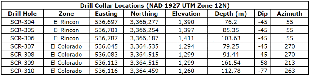
Drill collar locations, azimuths and dips for the drill holes included are provided in the table below
| Drill Collar Locations (NAD 1927 UTM Zone 12N) | |||||||
| Drill Hole | Zone | Easting | Northing | Elevation | Depth (m) | Dip | Azimuth |
| SCR-311 | El Colorado | 536,130 | 3,364,461 | 1,260 | 112.78 | -66 | 192 |
| SCR-312 | El Colorado | 536,088 | 3,364,474 | 1,273 | 82.30 | -45 | 270 |
| SCR-313 | El Colorado | 536,102 | 3,364,587 | 1,322 | 100.58 | -45 | 235 |
| SCR-314 | El Colorado | 536,140 | 3,364,621 | 1,327 | 121.92 | -45 | 230 |
| SCR-315 | El Colorado | 536,165 | 3,364,651 | 1,321 | 131.06 | -45 | 217 |
| SCR-316 | San Quintin | 536,625 | 3,364,517 | 1,286 | 100.58 | -45 | 275 |
| SCR-317 | Buena Suerte | 536,632 | 3,364,579 | 1,241 | 100.58 | -45 | 270 |
| SCR-318 | Buena Suerte | 536,579 | 3,364,703 | 1,280 | 83.82 | -45 | 235 |
| SCR-319 | Buena Suerte | 536,538 | 3,364,701 | 1,286 | 82.30 | -45 | 235 |
| SCR-320 | Buena Suerte | 536,495 | 3,364,817 | 1,359 | 121.92 | -45 | 235 |
Quality Assurance/Quality Control (“QA/QC”) Measures and Analytical Procedures
Drill samples are collected with an airstream cyclone and passed into a splitter that divides each sample into quarters. The quartered samples are then bagged and sealed with identification. The sample group has blanks, standards and duplicates inserted into the sample stream.
ALS-Chemex collects the samples and transports them directly to the preparation laboratory in Hermosillo, Sonora. At the laboratory, part of each sample is reduced through crushing, splitting and pulverization from which 200 grams is sent to the ALS-Chemex assay laboratory in Vancouver. Thirty grams undergoes fire assay for gold with the resulting concentrated button of material produced is dissolved in acids and the gold is determined by atomic absorption. Another quantity of the sample is dissolved in four acids for an ICP multi-element analysis.
No QA/QC issues were noted with the results received from the laboratory.
Geologic Description
Cerro Caliche is located 45 kilometers east southeast of Magdalena de Kino in the Cucurpe-Sonora Mega-district of Sonora, Mexico. Multiple historic underground mines were developed in the concession including Cabeza Blanca, Los Cuervos, Japoneses, Las Abejas, Boluditos, El Colorado, Veta de Oro and Espanola. Mineralization types of the Cucurpe-Sonora Mega-district include variants of epithermal low sulfidation veins and related mineralized dikes and associated volcanic domes. Local altered and mineralized felsic dikes cut the mineralized meta-sedimentary rock units and may be associated with mineralization both in the dikes and meta-sedimentary rocks.
Qualified Person Statement
Stephen Kenwood, P.Geo., a Director of Sonoro, is a Qualified Person within the context of National Instrument 43-101 (NI 43-101) and has read and approved this news release. Readers are cautioned that the presence of mineralization in historic mines adjacent to, or on, Cerro Caliche is not necessarily indicative of economic gold mineralization residing in the concessions held by the Company.
About Sonoro Gold Corp.
Sonoro Gold Corp. is a publicly listed exploration and development company with two exploration-stage precious metal properties in Sonora State, Mexico. The Company has highly experienced operational and management teams with proven track records for the discovery and development of natural resource deposits.
On behalf of the Board of Sonoro Gold Corp.
Per: “Kenneth MacLeod”
Kenneth MacLeod
President & CEO
For further information, please contact:
Sonoro Gold Corp. – Tel: (604) 632-1764
Email: info@sonorogold.com
- Published in Mining, News Home, Sonoro Gold
SONORO GOLD REPORTS HIGH GRADE INTERCEPTS AT CERRO CALICHE INCLUDING 9.14 METERS AVERAGING 9.577 GRAMS OF GOLD PER TONNE
Sonoro Gold Corp. (TSXV: SGO | OTCQB: SMOFF | FRA: 23SP) (“Sonoro” or the “Company”) is pleased to report assay results from an additional seven drill holes completed at its Cerro Caliche gold project in Sonora, Mexico. Results reflect recent drilling activity conducted at two of the property’s gold mineralized zones, El Colorado and El Rincon, with the reported intercepts situated outside of the pit shells used to calculate the mineral resource estimate announced in September 2021 as part of a Preliminary Economic Assessment (“PEA”) for a proposed heap leach mining operation.
Highlights are as follows:
- SCR-305 intercepted 36.5m averaging 0.54 g/t Au; including 1.53m averaging 3.59 g/t Au; including 1.53m averaging 3.32 g/t Au.
- SCR-307 intercepted 9.14m averaging 9.58 g/t Au; including 6.09m averaging 14.17 g/t Au; including 1.52m averaging 38.3 g/t Au.
- SCR-309 intercepted 6.10m averaging 1.37 g/t Au; including 1.53 averaging 3.97 g/t Au.
The map below illustrates the location of the drill holes.
Figure 1: New Drill Holes
The drilling campaign at Cerro Caliche is now complete with final assays expected to be announced in June. New geological data from over 7,200 meters and 63 drill holes will be included in a further updated resource estimate scheduled to be released in the fall of 2022. The updated technical report will also assess the potential economic impact of the new drilling data on the proposed heap leach mining operation.
Mel Herdrick, Sonoro’s VP Exploration, commented, “We continue to report good gold bearing intervals of mineralization as well as higher–grades intercepts that continue to add to potential mineralized material. Results from another 15 drill holes are still pending andwe are working to determine the structural controls of the new higher–grade zones.”
Kenneth MacLeod, Sonoro’s President and CEO, commented, “Our continued success with demonstrating high-grade intercepts at the Colorado zone suggests the potential for an increase in both the grade and size of the gold resource at El Colorado. Additional success at the Rincon zone through infill drilling has also achieved our objective of identifying continuous mineralization between two pit shells located 400meters apart, suggesting the potential for coalescing the pit shells into one larger pit shell.”
John Darch, Sonoro’s Chairman, noted, “The expansion of the El Colorado and El Rincongold mineralized zones, along with the multiple higher-grade intercepts we have announced during the Phase IV drilling program, adds to our optimism that this new geological data may potentially increase both the size and gold grade of the resource.If confirmed, an expanded resource may also improve the project‘spotential economics and extend the mine life of the proposedmining operation.”
El Colorado Gold MineralizedZone
Continued expansion of El Colorado was confirmed with four drill holes completed along the western side of the zone. The shallow, high-grade intercepts of drill hole SCR-307 returned 9.14 meters averaging 9.577 grams of gold per tonne (“g/t Au”) including 6.09 meters averaging 14.167 g/t Au and 1.52 meters averaging 38.3 g/t Au. SCR-307 does not correlate with any known projected vein and may be part of a series of high-grade ore shoots connected to deeper high-grade occurrences in the footwall of the Guadalupe vein structure, believed to be a continuation of El Colorado vein system as discussed in the Company’s News Release dated March 1, 2022.
The Company is also investigating a possible physical connection of SCR-307 to SCR-036 which, as previously announced, intercepted 1.52 meters averaging 11.45 g/t Au. These structures which appear near horizontal in attitude, contain higher gold grades with low silver levels and lead levels exceeding one percent. It is believed that the ore shoots are a repeating series of veins developed in a reverse fault episode which opened horizontal structures in the footwall of the Guadalupe Vein zone allowing higher-grade fluids to deposit gold and lead. Assay results from five holes at El Colorado are pending.
The geology of the El Colorado mineralized zone is complex with a mixture of silicified meta-sedimentary units intruded by a silicified and argillic altered quartz porphyry igneous body and, in deeper parts, granodiorite with dioritic to andesitic dikes. The mineralized structures trending north 10 west and dipping northeasterly cross the zone extending southerly from the Cabeza Blanca quartz veins. As many as five high-grade ore shoots intersect the Guadalupe footwall and the zone contains numerous additional veins and veinlets that are situated apart from the above-described vein zones.
Figure 2: Drill holes at El Colorado
Figure 3: Interpretive Cross Section at El Colorado
El Rincon
Approximately two kilometers north of El Colorado, six drill holes were completed along the northwest trending El Rincon structure between two separate pit shells used to calculate the September 2021 mineral resource estimate. These pit shells are approximately 400 meters apart with continuation of mineralization between the pit shells confirmed by a total of 16 drill holes, over approximately one kilometer of strike length. Drill holes SCR-301 through SCR-306 were infill drilling completed during the current program.
Results from drill holes SCR-301, SRC-302 and SCR-303 were announced on April 21, 2022, and drill holes SCR-304, SCR-305 and SCR-306 are detailed in the table below. Highlights include drill hole SCR-304 which intercepted 1.52 meters averaging 2.49 g/t Au and drill hole SCR-305 which intercepted 36.5 meters, averaging 0.535 g/t Au, including 1.53 meters averaging 3.59 g/t Au and 1.53 meters averaging 3.32 g/t Au.
The structure’s trend is azimuth 310 with dip of 85 northwest to vertical. This vein structure cuts both rhyolitic dikes and sills and bedded meta-sedimentary rocks with gold silver mineralization occurring in both rock types. The El Rincon vein zones are generally parallel to, or along, the rhyolite dike margins.
Figure 4: Drill holes at El Rincon
The following table provides the assay results for the complete list of reported drill holes:
Drill collar locations, azimuths and dips for the drill holes included are provided in the table below.
Quality Assurance/Quality Control (“QA/QC“) Measures and Analytical Procedures
Drill samples are collected with an airstream cyclone and passed into a splitter that divides each sample into quarters. The quartered samples are then bagged and sealed with identification. The sample group has blanks, standards and duplicates inserted into the sample stream.
ALS-Chemex collects the samples and transports them directly to the preparation laboratory in Hermosillo, Sonora. At the laboratory, part of each sample is reduced through crushing, splitting and pulverization from which 200 grams is sent to the ALS-Chemex assay laboratory in Vancouver. Thirty grams undergoes fire assay for gold with the resulting concentrated button of material produced is dissolved in acids and the gold is determined by atomic absorption. Another quantity of the sample is dissolved in four acids for an ICP multi-element analysis.
No QA/QC issues were noted with the results received from the laboratory.
Geologic Description
Cerro Caliche is located 45 kilometers east southeast of Magdalena de Kino in the Cucurpe-Sonora Mega-district of Sonora, Mexico. Multiple historic underground mines were developed in the concession including Cabeza Blanca, Los Cuervos, Japoneses, Las Abejas, Boluditos, El Colorado, Veta de Oro and Espanola. Mineralization types of the Cucurpe-Sonora Mega-district include variants of epithermal low sulfidation veins and related mineralized dikes and associated volcanic domes. Local altered and mineralized felsic dikes cut the mineralized meta-sedimentary rock units and may be associated with mineralization both in the dikes and meta-sedimentary rocks.
Qualified Person Statement
Stephen Kenwood, P.Geo., a Director of Sonoro, is a Qualified Person within the context of National Instrument 43-101 (NI 43-101) and has read and approved this news release. Readers are cautioned that the presence of mineralization on historic mines adjacent to or on Cerro Caliche is not necessarily indicative of economic gold mineralization in the concessions held by the Company.
About Sonoro Gold Corp.
Sonoro Gold Corp. is a publicly listed exploration and development company with a portfolio of exploration-stage precious metal properties in Sonora State, Mexico. The Company has highly experienced operational and management teams with proven track records for the discovery and development of natural resource deposits.
On behalf of the Board of Sonoro Gold Corp.
Per: “Kenneth MacLeod“
Kenneth MacLeod
President & CEO
For further information, please contact:
Sonoro Gold Corp. – Tel: (604) 632-1764
Email: info@sonorogold.com
- Published in Mining, News Home, Sonoro Gold
SONORO ANNOUNCES POSITIVE UPDATED PEA RESULTS INCREASING PRE-TAX NPV TO USD $84.4 MILLION AND PRE-TAX IRR TO 74.9%
Sonoro Gold Corp. (TSXV: SGO | OTCQB: SMOFF | FRA: 23SP) (“Sonoro” or the “Company”) is pleased to announce the positive results of an updated independent Preliminary Economic Assessment (“PEA”) on the Company’s Cerro Caliche gold project located in Sonora State, Mexico. The updated PEA highlights several opportunities to potentially increase the project’s previously reported economic parameters, as well as potentially lower several identified risks. As the engineering and costing outlined in both the initial and updated studies are at the PEA level, potential variations in operation and capital costs may occur.
Based on the same mineral resource estimate contained in the Company’s initial PEA, dated October 29, 2021, the updated PEA contemplates an optimized mine plan for an open pit, heap leach mining operation with an initial two-year production rate of 8,000 metric tonnes per day (“mtpd”) and an increase to 15,000 mtpd for the remaining life of mine (“LOM”).
The updated PEA has been prepared in accordance with the requirements of National Instrument 43-101 (“NI 43-101”) by D.E.N.M. Engineering Ltd. of Burlington, Ontario (“D.E.N.M.”), with confirmation of the applicable resource estimates completed by Micon International Limited of Toronto, Ontario (“Micon”).
Updated PEA Highlights:
- Pre-Tax net present value discounted at 5% (“NPV5“) of USD $84.4 million
- Pre-Tax Internal Rate of Return (“IRR”) of 74.9%
- After-Tax NPV5 of USD $53.5 million with an IRR of 45.6%
- Gold recovery of 74% and silver recovery of 27%
- 7-year LOM with 344,500 ounces (“oz”) of gold equivalent (“AuEq”)
- LOM annual average production of 45,000 oz AuEq (Years 1-7)
- Years 1 to 3 annual production of 46,000 oz AuEq at 0.58 g/t AuEq
- Initial CAPEX costs of USD $26 million, including USD $3 million in contingency
- Sustaining capital costs of USD $7.4 million
- Cash(1) costs of USD $1,206/oz AuEq
- AISC(2) of USD $1,333/oz AuEq
- Payback period of 2.2 years
Note: All currencies are reported in U.S. dollars. Base case parameters assume $1,750/oz of gold and $22/oz of silver.
(1) Cash costs include mining, crushing, processing, assaying, and administration.
(2) All–in–Sustaining Costs include cash costs plus sustaining, refining and reclamation costs, as well as 2% royalties.
Ken MacLeod, President and CEO of Sonoro, stated, “We are very pleased with the improved economic parameters of the updated PEA. Using the same resource calculations of the original PEA, we have optimized the mine plan to contemplate commencing production at a lower rate utilizing higher-grade ore, eventually ramping up to potential capacity of 15,000 mtpd in year three. The result is a reduction in the estimated initial CAPEX of over 19% and an increase in after–tax NPV and IRR of 29% and 40.4%, respectively.”
John Darch, Chairman of Sonoro, added, “The updated PEA again highlights the intrinsic value of the Cerro Caliche project, and we continue to assess options to potentially further improve the project’s economic viability, such as leasing large capital cost equipment.The updated PEA does not include the nearly completed drilling campaign, which commenced in November 2021 after the initial PEA was published. We are excited to review the potential for resource growth from the new geological data. An increase in the size and grade of the resource may potentially further improve the project’s economics and extend the proposed life of mine.”
Mineral Resource Estimate
The updated PEA utilizes the same geological data as the initial PEA, filed in October 2021, and is based on the Company’s September 2018 to April 2021 drilling campaigns. As previously announced, the PEA estimates Measured and Indicated Mineral Resources of 349,000 ounces of gold at a 0.41 g/t Au grade and Inferred Mineral Resources of 71,000 ounces of gold at 0.40 g/t Au grade. The original report also notes a range of the potential mineralization that may conceptually exist outside of the resource pit shells believed to be from 19,250,000 to 34,370,000 tonnes containing 204,000 to 365,000 ounces of gold, as well as 1,683,000 to 3,005,000 ounces of silver.
Readers are cautioned that these potential mineralization ranges are conceptual in nature and that despite being based on a limited amount of exploration drilling and sampling outside the current resource pit shells, it is uncertain that further exploration will result in the mineralization targets being delineated as a mineral resource.
Drilling Data
Approximately 7,000 meters of additional drilling being completed at Cerro Caliche was not included in the current mineral resource estimate. Final assay results are still pending with the new geological data to be included in a further updated resource estimate scheduled to be released in the fall of 2022.
Since drilling resumed in November 2021, the Company has announced multiple high-grade intercepts and expansions of several known mineralized zones in the southwestern region of the property. The potential economic impact of these results on the proposed mining operation will also be assessed in the updated resource estimate.
PEA Summary
The optimized mine plan outlined in the updated PEA increased total tonnes processed from 31.5 million tonnes to 32.2 million tonnes and total waste from 65.5 million tonnes to 66.8 million tonnes. Optimization also increased the average gold grade from 0.41 g/t Au to 0.43 g/t Au for the LOM, as well as the average gold equivalent from 0.51 g/t AuEq to 0.58 g/t AuEq during the first three years of production.
Total recovered gold equivalent increased from 323,550 ounces to 344,674 ounces.
The updated PEA is preliminary in nature and includes inferred resources that are considered too speculative to have the economic considerations applied to them that would enable them to be categorized as mineral reserves and there is no certainty the estimates presented in the PEA will be realized.
The full PEA will be filed on SEDAR at www.sedar.com and Sonoro’s website www.sonorogold.com within 45 days of the issuance of this news release.
Table 1: Key Economic Parameters
| Assumption / Results | Initial PEA Value | Updated PEA Value | Difference % | |||
| Pre-Tax NPV(5) (USD) | $68.7m | $84.4m | 22.9 | % | ||
| Pre-Tax IRR | 52.7 | % | 74.9 | % | 42.1 | % |
| After- Tax NPV(5) (USD) | $41.5m | $53.5m | 29.0 | % | ||
| After- Tax IRR | 32.4 | % | 45.6 | % | 40.4 | % |
| Revenues (USD) | $566.2m | $603.2m | 6.5 | % | ||
| Net Revenues (USD) | $67.2m | $81.3m | 21.0 | % | ||
| Total Tonnes Processed | 31.5mt | 32.2mt | 2.1 | % | ||
| Total Tonnes Waste | 65.5mt | 66.8mt | 2.0 | % | ||
| Mine Life | 7-Years | 7-Years | No Change | |||
| Strip Ratio | 2.08 | 2.08 | No Change | |||
| Gold Recovery | 74 | % | 74 | % | No Change | |
| Silver Recovery | 27 | % | 27 | % | No Change | |
| Gold Price (USD $/Au oz) | $ | 1,750 | $ | 1,750 | No Change | |
| Silver Price (USD $/Ag oz) | $ | 22 | $ | 22 | No Change | |
| Gold Grade (g/t Au) | 0.41 | 0.43 | 4.7 | % | ||
| Gold Equivalent Grade (g/t Au Eq) (Yrs. 1-3) | 0.51 | 0.58 | 13.7 | % | ||
| Silver Grade (g/t Au) | 4.05 | 4.01 | -1.0 | % | ||
| Total Gold Equivalent Recovered (oz) | 323,550 | 344,674 | 6.5 | % | ||
| Initial CAPEX Costs (USD) | $32.2m | $26.0m | -19.1 | % | ||
| Sustaining Capital Costs (USD) | $4.9m | $7.4m | 52.1 | % | ||
| LOM Operating Costs (USD) | $396.9m | $415.4m | 4.8 | % | ||
| Cash Cost (USD $/ AuEq oz) | $ | 1,227 | $ | 1,206 | -1.6 | % |
| AISC (USD $/ AuEq oz) | $ | 1,351 | $ | 1,333 | -1.3 | % |
Table 2: Economic Summary Comparison (USD)
| Economic Summary | Initial PEA | Updated PEA | ||||||
| Pre-Tax | After Tax | Pre-Tax | After Tax | |||||
| NPV5 | $68.7m | $41.5m | $84.4m | $53.5m | ||||
| IRR | 52.7 | % | 32.4 | % | 74.9 | % | 45.6 | % |
Table 3: Updated Gold & Silver Price Sensitivity Analysis (USD)
| Sensitivity | $1,700/ozAu $20/oz Ag | $1,750/oz Au $22/oz Ag | $1,800/oz Au $24/ozAg | $1,900/oz Au $26/oz Ag | $2,000/oz Au $28/ozAg | |||||
| Pre-Tax NPV5 | $70.4m | $84.4m | $98.4m | $124.9m | $151.4m | |||||
| Pre-Tax IRR | 65.4 | % | 74.9 | % | 84.1 | % | 101 | % | 117.3 | % |
| After-Tax NPV5 | $44.4m | $53.5m | $62.6m | $79.8m | $96.9m | |||||
| After-Tax IRR | 39.4 | % | 45.6 | % | 51.5 | % | 62.3 | % | 72.7 | % |
| Payback | 2.5 Years | 2.2 Year | 2.1 Years | 1.8 Years | 1.6 Years |
Table 4: Updated Operating & Capital Sensitivity Analysis (USD)
| Sensitivity | -20 | % | -10 | % | Base Case | 10 | % | 20 | % | |
| Operating Costs – Pre-tax NPV | $147.3m | $115.8m | $84.4m | $53.0m | $21.6m | |||||
| Operating Costs – IRR | 113.1 | % | 94.6 | % | 74.9 | % | 53.2 | % | 27.4 | % |
| Capital Costs – Pre-tax NPV | $94.5m | $89.7m | $84.4m | $78.6m | $72.3m | |||||
| Capital Costs – IRR | 124.0 | % | 95.4 | % | 74.9 | % | 59.7 | % | 48.1 | % |
Capital Costs
The updated estimated capital costs for the Cerro Caliche Gold Project are based on an open pit, heap leach operation with contract mining. Initial capital expenditures of USD $26 million, including 15% contingency, contemplates an initial two-year production rate of 8,000 mtpd with an increase to 15,000 mtpd in the third year of production.
Initial capital costs include direct facility costs such as crushing equipment, processing facilities and leach pad impoundment as well infrastructure, EPCM, site preparation and indirect facility costs such as technical studies, office equipment and light vehicles.
An additional USD $7.4 million is estimated for updated sustaining capital including the expansion of the crushing circuit and heap leach pad, as well as equipment and equipment replacement costs. Reclamation costs remain the same at an estimated USD $2.9 million.
Updated capital cost estimates are based on industry standards and were developed using quotes provided by mining contractors and specialists experienced in mining development in Mexico.
Table 4: Updated Initial Capital Costs
| Initial Capital Costs | Costs (USD) |
| Direct Facility Costs | $14.3m |
| Infrastructure | $4.2m |
| Engineering and Procurement | $2.8m |
| Indirect Facility Costs | $1.5m |
| Pre-Stripping and Mine Development | $0.2m |
| Contingency | $3.1m |
| Total | $26.0m |
Table 5: Updated Sustaining Capital Costs
| Sustaining Costs | Costs (USD) |
| Leach Pad Expansion | $2.4m |
| Crusher Expansion | $3.3m |
| Equipment and Other | $1.8m |
| Total | $7.4m |
Table 6: ReclamationCosts
| Capital Costs | Costs (USD) |
| Environmental | $2.3m |
| Engineering and Procurement | $0.3m |
| Contingency | $0.3m |
| Total | $2.9m |
Operating Costs
Updated cash costs for Cerro Caliche’s LOM are estimated at USD $415.8 million or USD $1,206 per gold equivalent ounce and include mining, crushing and processing, as well as maintenance and administration costs. Updated All-in Sustaining Costs for LOM are estimated at USD $459 million or US$1,333 per gold equivalent ounce and include operating costs, sustaining capital, reclamation, royalties and refining charges.
Royalties include a 2% NSR to certain landholders and taxes include payments to the Mexican government for mining royalty and specific mining related taxes. Refining costs include shipping loaded carbon to a 3rd party processing facility, as well as costs for processing the carbon and production of dore bars.
Open pit mining will be undertaken by a contractor and carried out by drill and blast conventional loading and truck haulage to the crushing facility. An estimated mining cost of USD $1.85 per tonne includes drilling, blasting, hauling waste and mineralized ore to the heap leach area.
The processing facilities at Cerro Caliche will be comprised of a crushing circuit where mineralized material is processed through a three-stage crushing plant to produce material that is p80 of one-half” (80% passing) method. The material is then conveyed and stacked in a conventional heap leach pad and irrigated with a low concentrate cyanide solution. An estimated crushing cost of USD $0.82 includes the cost of crushing and conveying. Solution collected from the leach pad is then directed through a system of channels to the processing ponds where it passes through a series of carbon columns. Gold and silver impregnated carbon is collected periodically from the columns and then dried and shipped to a 3rd party processing facility for stripping and dore bar production. An estimated processing cost of USD $5.80 per tonne operating costs includes leaching, assaying, carbon handling and labour.
Operating cost estimates are based on industry standards and were developed using quotes provided by mining contractors and specialists experienced in mining development in Mexico.
Table 5: Updated Operating Costs
| Operating Costs | LOM (USD) | $/oz AuEq | |
| Mining | $183.1m | $ | 531 |
| Processing | $213.0m | $ | 618 |
| Administration | $19.7m | $ | 57 |
| Total | $415.8m | $ | 1,206 |
Table 6: All-in-Sustaining Costs
| AISC Costs | LOM (USD) | $/oz AuEq | |
| Cash Costs | $415.8m | $ | 1,206 |
| Refining | $20.9m | $ | 61 |
| Royalties | $12.3m | $ | 36 |
| Sustaining | $7.4m | $ | 21 |
| Closure | $2.9m | $ | 8 |
| Total | $459.3m | $ | 1,333 |
Qualified Person Statement
David Salari, P.Eng. of D.E.N.M. Engineering Ltd., and William Lewis, P.Geo. of Micon International Limited, both of whom are independent of the Company, have reviewed and approved the scientific and technical information herein regarding the Company’s Cerro Caliche Project. William Lewis, P.Geo., was responsible for the updated Cerro Caliche Mineral Resource Estimate and, along with David Salari, P.Eng., has approved the information pertaining to the Cerro Caliche Project in this news release. Each of David Salari, P.Eng. and William Lewis, P.Geo., is a Qualified Person as defined in NI 43-101.
Stephen Kenwood, P.Geo., a Director of Sonoro Gold, is a Qualified Person within the context of NI 43-101 and has read and approved this news release.
About D.E.N.M. Engineering Limited
D.E.N.M. Engineering Ltd. is a niche engineering company servicing the mining / mineral processing sector that specializes in Engineering & Design, Equipment Supply, Project & Construction Management, Commissioning and Operations Support. D.E.N.M. Engineering Ltd. has proven success while championing projects for over fifteen years in Canada, USA, Mexico and Central America.
In addition, D.E.N.M. Engineering, with its principal and independent specialists, performs NI 43-101 compliant assessments and studies in the sections of mineral processing metallurgical design, process design, capital and operating costing and cash flow analysis.
About Micon International Limited
Micon International Limited (Micon) has provided consulting services to the worldwide mining industry since 1988 from its offices in Canada and the UK. Micon comprises a multi-disciplinary group of highly qualified and experienced professionals who are guided by the Company principles of Integrity, Competence and Independence.
Micon’s experience in Mexico ranges from exploration programs and resource estimation to technical studies on operating mines, as well as due diligence for precious metals and base metals projects. Micon has worked in most of the major mining districts throughout Mexico, as well as some lesser-known historical districts. In northern Mexico, assignments have been undertaken in the gold and silver districts of Sonora, Durango, Zacatecas, Chihuahua and Baja California.
About Sonoro Gold Corp.
Sonoro Gold Corp. is a publicly listed exploration and development company holding the near development stage Cerro Caliche project and the exploration stage San Marcial properties in Sonora State, Mexico. The Company has highly experienced operational and management teams with proven track records for the discovery and development of natural resource deposits.
On behalf of the Board of Sonoro Gold Corp.
Per: “Kenneth MacLeod”
Kenneth MacLeod
President & CEO
For further information, please contact:
Sonoro Gold Corp. – Tel: (604) 632-1764
Email: info@sonorogold.com
- Published in Sonoro Gold
SONORO SUBMITS FEDERAL ENVIRONMENTAL PERMIT APPLICATION FOR CERRO CALICHE
Sonoro Gold Corp. (TSXV: SGO | OTCQB: SMOFF | FRA: 23SP) (“Sonoro” or the “Company”) is pleased to announce it has filed an Environmental Impact Statement, or Manifestacion de Impacto Ambiental (“MIA”) for its Cerro Caliche gold project in Sonora, Mexico. Under Mexican law, mining construction and operation activities require an approved MIA, as well as a Change of Land Use permit, or Autorizacion en Cambio de Uso de Suelo (“ETJ”), from the Mexican federal permitting authority, Secretaria de Medio Ambiente y Recursos Naturales (“SEMARNAT”). The Company is currently completing the required documentation for the Change of Land Use application and anticipates filing with SEMARNAT in the near future.
“Completing the MIA provided us with an opportunity to work closely with various stakeholders and I would like to thank everyone who worked alongside us as we conducted multiple environmental baseline studies and socio-economic assessments,” stated VP of Operations, Jorge Diaz. “The filing of the MIA is an important step in the project’s development and we will continue to move the project forward during the permitting process.”
Kenneth MacLeod, Sonoro’s President and CEO commented, “The filing of the MIA follows the compilation of extensive technical and environmental studies conducted on the Cerro Caliche concession over the past four years and supports the Company’s objective to develop Sonoro’s proposed heap leach mining operation.“
John Darch, Sonoro’s Chairman added, “We are delighted to report to our shareholders the filing of the Environmental Impact Statement, as it is a key milestone in the development of our proposed heap leach mining operation.”
The scope of the MIA includes open pits, waste dumps, crushing facilities, heap leach pad, leach solution ponds, gold recovery facilities, haul roads, building structures and infrastructure, as proposed in the Company’s Preliminary Economic Assessment dated October 29, 2021. The document also provides flexibility for the continual optimization of the mine plan to support operational growth and resource expansion.
During the MIA-ETJ permitting phase, the Company will continue to move the project forward as it initiates site preparation work and focuses on arranging project financing. Management will also update the project’s estimated resource to incorporate the results from its nearly completed Phase IV drilling program and assess the potential impact on the project’s mine life and economic viability.
About Sonoro Gold Corp.
Sonoro Gold Corp. is a publicly listed exploration and development Company holding the near-development-stage Cerro Caliche project and the exploration-stage San Marcial project in Sonora State, Mexico. The Company has highly experienced operational and management teams with proven track records for the discovery and development of natural resource deposits.
On behalf of the Board of SONORO GOLD CORP.
Per: “Kenneth MacLeod“
Kenneth MacLeod
President & CEO
For further information, please contact:
Sonoro Gold Corp. – Tel: (604) 632-1764
Email: info@sonorogold.com
- Published in Mining, News Home, Sonoro Gold
SONORO GOLD ANNOUNCES $3 MILLION PRIVATE PLACEMENT
Sonoro Gold Corp. (TSXV: SGO | OTCQB: SMOFF | FRA: 23SP) (“Sonoro” or the “Company”) is pleased to announce that it will undertake a non-brokered private placement offering (the “Offering”) consisting of up to 17,000,000 units (the “Units”) at a price of C$0.18 per Unit, for gross proceeds of up to C$3,060,000. Each Unit will be composed of one Sonoro common share and one common share purchase warrant. Each warrant will entitle the holder thereof to purchase one additional Sonoro common share for a period of two years from the closing at an exercise price of C$0.30 per share.
The Company intends to pay finder’s fees, as permitted under the policies of the TSX Venture Exchange, in respect of Units placed with the assistance of registered securities dealers. All securities issued and issuable in connection with the Offering will be subject to a 4-month hold period in Canada from the closing date. The Offering is subject to TSX Venture Exchange acceptance.
The net proceeds from the Offering will be used to fund the ongoing development of a proposed heap leach mining operation at the Company’s Cerro Caliche gold project in Sonora, Mexico. Funds will be allocated principally for permitting, land agreements, drilling and technical studies, and secondarily for corporate and general administrative expenses.
Kenneth MacLeod, President and CEO of Sonoro, stated, “The private placement will provide sufficient capital to complete several key steps in the development of the proposed mining operation including permitting, land agreements and condemnation drilling. Furthermore, with the near completion of our Stage IV drilling campaign which successfully returned multiple higher-grade intercepts and extended several mineralized zones on the property, this financing will also allow us to start updating the project’s estimated resource and assessing the potential economic impact of the new drilling data on the proposed operation.”
About Sonoro Gold Corp.
Sonoro Gold Corp. is a publicly listed exploration and development Company holding the near-development-stage Cerro Caliche project and the exploration-stage San Marcial project in Sonora State, Mexico. The Company has highly experienced operational and management teams with proven track records for the discovery and development of natural resource deposits.
On behalf of the Board of SONORO GOLD CORP.
Per: “Kenneth MacLeod“
Kenneth MacLeod
President & CEO
For further information, please contact:
Sonoro Gold Corp. – Tel: (604) 632-1764
Email: info@sonorogold.com
- Published in News Home, Sonoro Gold
SONORO GOLD REPORTS HIGH GRADE INTERCEPTS AT CERRO CALICHE INCLUDING 10.67 METERS OF 9.02 GRAMS OF GOLD PER TONNE
Sonoro Gold Corp. (TSXV: SGO | OTCQB: SMOFF | FRA: 23SP) (“Sonoro” or the “Company”) is pleased to report assay results from an additional 15 drill holes completed as part of a drilling campaign currently underway at its Cerro Caliche gold project in Sonora, Mexico. As previously announced, the objective of the program is to increase the estimated size and grade of the project’s oxide gold mineralization as well as to potentially extend the estimated life of the proposed heap leach mining operation as outlined in the Preliminary Economic Assessment (PEA) filed in October 2021.
These latest results include drilling conducted at El Colorado and Guadalupe gold mineralized zones in the southwest of the concession’s mineralized zones where multiple high-grade gold intercepts were previously reported within larger intervals of higher-grade gold mineralization, as well as at El Bellotoso gold mineralized zone in the northeast region.
Highlights are as follows:
- SCR-289 intercepted 7.62m averaging 0.562 g/t Au; including 1.52m averaging 1.385 g/t Au
- SCR-292 intercepted 3.04m averaging 1.765 g/t Au; including 1.52m averaging 3.370 g/t Au
- SCR-293 intercepted 12.19m averaging 0.874 g/t Au; including 1.52m averaging 3.62 g/t Au;
and 6.10m averaging 0.922 g/t Au; including 1.53m averaging 2.22 g/t Au;
and 7.62m averaging 2.262 g/t Au; including 1.53m averaging 10.25 g/t Au
- SCR-295 intercepted 1.52m averaging 1.455 g/t Au; and 1.53m averaging 6.00 g/t Au
- SCR-296 intercepted 7.62m averaging 0.673 g/t Au; including 1.53m averaging 1.835 g/t Au;
and 6.10m averaging 0.422 g/t Au; including 1.52m averaging 1.00 g/t Au
- SCR-298 intercepted 3.05m averaging 0.884 g/t Au; including 1.53m averaging 1.455 g/t Au
- SCR-299 intercepted 10.67m averaging 9.018 g/t Au; including 6.10m averaging 15.558 g/t Au
- SCR-301 intercepted 10.67m averaging 0.497 g/t Au; including 1.52m averaging 1.795 g/t Au
Mel Herdrick, Sonoro’s VP Exploration noted, “With the discovery of multiple prospective high-grade ore-shoots identified by drilling at El Colorado, we are developing an understanding of the permissible extent and trend of these potential ore-shoots that may have up to seven additional repetitions in the footwall of the Guadalupe vein zone extendingup to 700 meters to the northwest of El Colorado. These high-grade ore-shoots may add significantly to the existing resource. The process of defining these zones also allows us to refine our understanding of the structural geology and, consequently, identify additional areas for possible material resource expansion and a recalculation of the existing resource.”
Kenneth MacLeod, Sonoro’s CEO and President commented, “We continue to be very pleased with the results from our Phase IV drilling program which is expected to be completed by early May with the remaining results expected at the end of May. While we move forward with the development of the proposed mining operations, we will now begin assessing the potential economic impact of the new geological data on the project.”
John Darch, Sonoro’s Chairman commented, “We are very encouragedwith thelatest drilling results.The extension of several gold mineralized zones as well as the multiple deeper higher-grade intercepts suggests the drilling program may meet its objective ofincreasingthe size and grade of the resourceand therefore potentially extend the life of our proposed mining operation as well as improve the overall economics of the project. This is a very exciting time for Sonoro and its shareholders.“
The map below illustrates the location of the drill holes.
Figure 1: New Drill Holes
El Colorado Zone
On March 1, 2022, the Company announcedthat drill hole SCR-286 had intercepted high-grade gold mineralization at the deepest level of El Colorado’s epithermal system drilled to date. Eight drill holeswere recently completed at El Colorado to expand mineralization near this intercept,including drill hole SCR-289 which intercepted 7.62meters averaging 0.562 g/t Au, including 1.52meters averaging 1.385 g/t Au. Drill hole SCR-290 was drilled at a 60-degree inclination following strike and is located below SCR-286 where it intercepted 3.05 meters averaging 0.378 g/t Au.In close proximity, SCR-292 intercepted 3.04meters averaging 1.765 g/t Au, including 1.52meters averaging 3.370 g/t Au.
Vertical drill hole SCR-298 intercepted 3.05 meters averaging 0.884 g/t Au, including 1.53 meters averaging 1.455 g/t Au and drill hole SCR-299 intercepted 4.58 meters averaging 0.497 g/t Au and 10.67 meters averaging 9.01 g/t Au, including 6.10 meters averaging 15.558 g/t Au located at depth of 64.01 meters and approximately 50 meters northwest of SCR-286.
Vertical drill hole SCR-300 intercepted 3.04 meters averaging 0.407 g/t Au, near the projected intercept area where gold is anomalous with high values of lead and zinc. A lost interval at 117 meters showed high manganese oxide content with no sample and high-water flow suggesting a post mineral fault which may displace the mineralization.
Two drill holeswere also completed outside of the resource pit shell used to calculate the zone’s gold resource in the updated Mineral Resource Estimate.Drill hole SCR-291 is approximately 100 meters southeast of the proposed pit shell where it intercepted 3.05 meters averaging 0.530 g/t Au, including 1.53 meters averaging 1.670 g/t Au. Drill hole SCR-293 is approximately 30 meters eastof the pit shell where it intercepted 12.19metersfrom surface averaging 0.874 g/t Au, including 1.52meters averaging 3.62 g/t Au.At a depth of 184.4 meters, the same drill hole intercepted 7.62meters averaging 2.262 g/t Au, including 1.53meters averaging 10.25 g/t Au.
Figure 2: Interpretive Cross Section at El Colorado
Guadalupe Zone
At the Guadalupe zone, four drill holes were collared on the western side of the proposed resource pit cone for calculating the zone’s gold resource as outlined in the updated Mineral Resource Estimate. Drill hole SCR-294 intercepted 3.05 meters averaging 0.525 g/t Au at a depth of 121.92 meters and drill hole SCR-295 intercepted 1.52 meters averaging 1.455 g/t Au at a depth of 112.78 meters and intercepted another 1.53 meters averaging 6.00 g/t Au at a depth of 164.59 meters.
Intervals in drill holes SCR-296 and SCR-297 show extensions of the gold mineralization along the southeastern trend and drill hole SCR-294 contained short intervals representing stockwork type mineralization but the average grades reported are below the PEA resource cutoff for inclusion.
El Bellotoso Zone
In the northeast region of the property, drilling at El Bellotoso intercepted gold mineralization, extending the zone 200 meters along strike. Four drill holes were completed with drill holeSCR-301returning the best results. SCR-301 was collared at the southeastern side of the proposed El Rincon pit cone and intercepted 10.67meters averaging 0.497 g/t Au from near surface, including 1.52 meters averaging 1.795 g/t Au.
The following table provides the assay results for the complete list of reported drill holes:
| Cerro Caliche Project, Holes Composites with Cut-off 0.15 g/t Au | ||||||||
| Hole | Target | From | To | Interval | Au | Ag | AuEq | |
| Meters | g/t | g/t | g/t | |||||
| SCR-289 | El Colorado | 3.05 | 10.67 | 7.62 | 0.562 | 0.80 | 0.566 | |
| including | 7.62 | 9.14 | 1.52 | 1.385 | 0.80 | 1.389 | ||
| SCR-290 | El Colorado | 79.25 | 82.30 | 3.05 | 0.378 | 1.40 | 0.385 | |
| SCR-291 | El Colorado | 27.43 | 30.48 | 3.05 | 0.530 | 0.70 | 0.533 | |
| and | 42.67 | 44.20 | 1.53 | 1.670 | 11.40 | 1.722 | ||
| SCR-292 | El Colorado | 36.58 | 39.62 | 3.04 | 1.765 | 1.40 | 1.771 | |
| including | 38.10 | 39.62 | 1.52 | 3.370 | 1.40 | 3.376 | ||
| SCR-293 | El Colorado | 0.00 | 12.19 | 12.19 | 0.874 | 2.00 | 0.883 | |
| including | 10.67 | 12.19 | 1.52 | 3.620 | 2.20 | 3.630 | ||
| and | 65.53 | 67.06 | 1.53 | 1.845 | 0.80 | 1.849 | ||
| and | 134.11 | 140.21 | 6.10 | 0.922 | 1.50 | 0.929 | ||
| including | 134.11 | 135.64 | 1.53 | 2.220 | 1.60 | 2.227 | ||
| and | 184.40 | 192.02 | 7.62 | 2.262 | 3.70 | 2.279 | ||
| including | 187.45 | 188.98 | 1.53 | 10.250 | 14.10 | 10.315 | ||
| SCR-294 | Guadalupe | 89.92 | 96.01 | 6.09 | 0.336 | 6.30 | 0.365 | |
| and | 121.92 | 124.97 | 3.05 | 0.525 | 0.30 | 0.526 | ||
| SCR-295 | Guadalupe | 1.52 | 15.24 | 13.72 | 0.380 | 1.10 | 0.385 | |
| and | 102.11 | 114.30 | 12.19 | 0.380 | 3.00 | 0.394 | ||
| including | 112.78 | 114.30 | 1.52 | 1.455 | 1.50 | 1.462 | ||
| and | 164.59 | 166.12 | 1.53 | 6.000 | 2.60 | 6.012 | ||
| SCR-296 | Guadalupe | 0.00 | 7.62 | 7.62 | 0.673 | 2.90 | 0.686 | |
| including | 4.57 | 6.10 | 1.53 | 1.835 | 6.20 | 1.863 | ||
| and | 19.81 | 25.91 | 6.10 | 0.422 | 0.60 | 0.425 | ||
| including | 21.34 | 22.86 | 1.52 | 1.000 | 0.70 | 1.003 | ||
| and | 32.00 | 36.58 | 4.58 | 0.309 | 1.40 | 0.316 | ||
| and | 92.96 | 100.58 | 7.62 | 0.276 | 2.00 | 0.285 | ||
| SCR-297 | Guadalupe | 0.00 | 4.57 | 4.57 | 0.424 | 3.20 | 0.439 | |
| and | 79.25 | 83.82 | 4.57 | 0.166 | 1.40 | 0.172 | ||
| SCR-298 | El Colorado | 12.19 | 18.29 | 6.10 | 0.462 | 2.20 | 0.472 | |
| and | 24.38 | 27.43 | 3.05 | 0.884 | 2.70 | 0.896 | ||
| including | 24.38 | 25.91 | 1.53 | 1.455 | 4.70 | 1.477 | ||
| and | 56.39 | 59.44 | 3.05 | 0.226 | 0.70 | 0.230 | ||
| SCR-299 | El Colorado | 9.14 | 13.72 | 4.58 | 0.497 | 0.50 | 0.499 | |
| and | 57.91 | 68.58 | 10.67 | 9.018 | 5.20 | 9.042 | ||
| including | 57.91 | 64.01 | 6.10 | 15.558 | 8.70 | 15.598 | ||
| SCR-300 | El Colorado | 13.72 | 16.76 | 3.04 | 0.407 | 2.70 | 0.419 | |
| and | 19.81 | 22.86 | 3.05 | 0.229 | 0.30 | 0.231 | ||
| SCR-301 | El Bellotoso | 10.67 | 21.34 | 10.67 | 0.497 | 0.80 | 0.501 | |
| including | 10.67 | 12.19 | 1.52 | 1.795 | 1.00 | 1.800 | ||
| and | 24.38 | 28.96 | 4.58 | 0.170 | 1.60 | 0.178 | ||
| and | 35.05 | 53.34 | 18.29 | 0.199 | 0.50 | 0.201 | ||
| and | 71.63 | 74.68 | 3.05 | 0.175 | 1.70 | 0.183 | ||
| and | 79.25 | 85.34 | 6.09 | 0.409 | 2.40 | 0.420 | ||
| and | 106.68 | 111.25 | 4.57 | 0.401 | 0.30 | 0.402 | ||
| SCR-302 | El Bellotoso | 16.76 | 22.86 | 6.10 | 0.259 | 14.00 | 0.323 | |
| and | 39.62 | 54.86 | 15.24 | 0.361 | 16.00 | 0.434 | ||
| SCR-303 | El Bellotoso | 25.91 | 32.00 | 6.09 | 0.241 | 7.90 | 0.278 |
Drill collar locations, azimuths and dips for the drill holes included are provided in the table below.
| Drill Collar Locations (NAD 1927 UTM Zone 12N) | |||||||
| Drill Hole | Zone | Easting | Northing | Elevation | Depth (m) | Dip | Azimuth |
| SCR-289 | El Colorado | 536,228 | 3,364,440 | 1,196 | 121.92 | -60 | 219 |
| SCR-290 | El Colorado | 536,273 | 3,364,478 | 1,194 | 134.11 | -60 | 222 |
| SCR-291 | El Colorado | 536,281 | 3,364,436 | 1,189 | 121.92 | -80 | 228 |
| SCR-292 | El Colorado | 536,257 | 3,364,419 | 1,179 | 112.78 | -70 | 228 |
| SCR-293 | El Colorado | 536,224 | 3,364,596 | 1,263 | 234.7 | -48 | 195 |
| SCR-294 | Guadalupe | 535,998 | 3,365,088 | 1,415 | 172.21 | -45 | 260 |
| SCR-295 | Guadalupe | 536,044 | 3,365,047 | 1,384 | 173.74 | -45 | 260 |
| SCR-296 | Guadalupe | 536,059 | 3,364,994 | 1,361 | 152.4 | -45 | 260 |
| SCR-297 | Guadalupe | 536,049 | 3,364,936 | 1,345 | 140.21 | -45 | 260 |
| SCR-298 | El Colorado | 536,202 | 3,364,428 | 1,216 | 128.02 | -90 | 0 |
| SCR-299 | El Colorado | 536,229 | 3,364,440 | 1,195 | 106.68 | -90 | 0 |
| SCR-300 | El Colorado | 536,224 | 3,364,406 | 1,193 | 134.11 | -90 | 0 |
| SCR-301 | El Bellotoso | 536,406 | 3,366,439 | 1,411 | 121.92 | -55 | 45 |
| SCR-302 | El Bellotoso | 536,508 | 3,366,388 | 1,402 | 91.44 | -55 | 45 |
| SCR-303 | El Bellotoso | 536,601 | 3,366,325 | 1,378 | 73.15 | -45 | 55 |
Quality Assurance/Quality Control (“QA/QC“) Measures and Analytical Procedures
Drill samples are collected with an airstream cyclone and passed into a splitter that divides each sample into quarters. The quartered samples are then bagged and sealed with identification. The sample group has blanks, standards and duplicates inserted into the sample stream.
ALS-Chemex collects the samples and transports them directly to the preparation laboratory in Hermosillo, Sonora. At the laboratory, part of each sample is reduced through crushing, splitting and pulverization from which 200 grams is sent to the ALS-Chemex assay laboratory in Vancouver. Thirty grams undergoes fire assay for gold with the resulting concentrated button of material produced is dissolved in acids and the gold is determined by atomic absorption. Another quantity of the sample is dissolved in four acids for an ICP multi-element analysis.
No QA/QC issues were noted with the results received from the laboratory.
Geologic Description
Cerro Caliche is located 45 kilometers east southeast of Magdalena de Kino in the Cucurpe-Sonora Mega-district of Sonora, Mexico. Multiple historic underground mines were developed in the concession including Cabeza Blanca, Los Cuervos, Japoneses, Las Abejas, Boluditos, El Colorado, Veta de Oro and Espanola. Mineralization types of the Cucurpe-Sonora Mega-district include variants of epithermal low sulfidation veins and related mineralized dikes and associated volcanic domes. Local altered and mineralized felsic dikes cut the mineralized meta-sedimentary rock units and may be associated with mineralization both in the dikes and meta-sedimentary rocks.
Qualified Person Statement
Stephen Kenwood, P.Geo., a Director of Sonoro, is a Qualified Person within the context of National Instrument 43-101 (NI 43-101) and has read and approved this news release. Readers are cautioned that the presence of mineralization on historic mines adjacent to or on Cerro Caliche is not necessarily indicative of economic gold mineralization in the concessions held by the Company.
About Sonoro Gold Corp.
Sonoro Gold Corp. is a publicly listed exploration and development company with a portfolio of exploration-stage precious metal properties in Sonora State, Mexico. The Company has highly experienced operational and management teams with proven track records for the discovery and development of natural resource deposits.
On behalf of the Board of Sonoro Gold Corp.
Per: “Kenneth MacLeod“
Kenneth MacLeod
President & CEO
For further information, please contact:
Sonoro Gold Corp. – Tel: (604) 632-1764
Email: info@sonorogold.com
- Published in Mining, News Home, Sonoro Gold
Sonoro Gold Reports Multiple High Grade Gold Intercepts at Cerro Caliche Including 27.43 Meters of 5.36 Grams of Gold per Tonne
Sonoro Gold Corp. (TSXV: SGO | OTCQB: SMOFF | FRA: 23SP) (“Sonoro” or the “Company”) is pleased to report the initial assay results from the first 24 drill holes of a 10,000-meter drilling campaign currently underway at its Cerro Caliche gold project in Sonora, Mexico. The objective of the program is to increase the estimated size and grade of the project’s oxide gold mineralization as well as to establish a basis for an extension of the estimated life of the proposed heap leach mining operation as outlined in the Preliminary Economic Assessment and updated Mineral Resource Estimate filed under the Company’s profile on SEDAR on October 29, 2021 (the “Mineral Resource Estimate”).
The results include drilling conducted in the gold mineralized zones of El Colorado and Guadalupe, located in the southwestern region of the property, where assays returned multiple higher-grade gold intercepts within larger intervals of high-grade gold mineralization. Drilling is continuing at both zones.
Highlights are as follows:
- SCR-266 intercepted 9.14m averaging 1.04 g/t Au; including 1.52m averaging 2.28 g/t Au; including 1.53m averaging 3.01 g/t Au
- SCR-277 intercepted 22.86m averaging 1.55 g/t Au; including 6.10m averaging 5.18 g/t Au; including 3.05m averaging 9.10 g/t Au
- SCR-280 intercepted 3.05m averaging 19.56 g/t Au; including 1.53m averaging 37.90 g/t Au
- SCR-282 intercepted 4.57m averaging 2.43 g/t Au; including 1.53m averaging 4.54 g/t Au
- SCR-286 intercepted 27.43m averaging 5.36 g/t Au; including 4.57m averaging 7.16 g/t Au; including 4.57m averaging 22.09 g/t Au; including 1.53m averaging 46.5 g/t Au
- SCR-287 intercepted 4.57m averaging 2.18 g/t Au; including 1.52m averaging 4.70 g/t Au
Mel Herdrick, Sonoro’s VP of Exploration commented, “These results indicate that we are successfully extending gold mineralization at Cerro Caliche while simultaneously demonstrating the potential for higher-grade mineralized zones deeper in the system.”
John Darch, Sonoro’s Chairman noted, “We are very pleased with these drilling results. The shallow high-grade drill intercepts and higher-grade gold intercepts at depth suggest the potential to increase both size and grade of the project’s resource, which, if confirmed, may not only extend the life of the proposed heap leach mine, but also may improve the overall economics of the project.”
Kenneth MacLeod, Sonoro’s CEO and President added, “These positive assay results support our decision to continue drilling while moving forward with the proposed development of an open pit mining operation. Confirmation of higher-grade intercepts at depth may suggest the possibility for underground gold mineralization. Further geological data is required, but we are very encouraged by these initial results.”
The map below illustrates the location of the drill holes.
A Media Snippet accompanying this announcement is available by clicking on the image or link below:
El Colorado Zone
When combined with prior drilling results, the current Infill and expansion drilling at the higher-grade El Colorado gold mineralized zone, reveal the presence of blind (lack of surface exposure) irregular higher-grade, low angle vein occurrences. These occurrences range from 10 to 70 meters below the present surface and may be included in future open pit cone determinations.
Drill hole SCR-286 intercepted high-grade gold mineralization at the deepest level of El Colorado’s epithermal system drilled to date. Near the bottom of the hole, a 27.43 meter intercept averaged 5.36 g/t Au, including 4.57 meters averaging 7.16 g/t Au, and 4.57 meters of 22.09 g/t Au, including 1.53 meters averaging 46.5 g/t Au and 1.52 meters averaging 3.25 g/t Au. As drilling stopped at this last gold intercept, future close-in drilling is planned to test for potentially deeper extension of the drill hole’s mineralization.
The high-grade SCR-286 intercept consists of vein and mega stock work located approximately 120 vertical meters lower than the resource pit cone used to calculate the zone’s gold resource in the updated Mineral Resource Estimate. The intercept begins underneath a gulley 80 meters immediately southeast of the pit cone proposed for the north slope of the gulley, and approximately 75 meters below surface with the mineralization continuing southeast under the south slope of the gully. Mineralization at El Colorado remains open to the northwest, the southeast and to depth.
A Media Snippet accompanying this announcement is available by clicking on the image or link below:
Guadalupe Zone
At Guadalupe, SCR-277 intercepted 22.86 meters averaging 1.55 g/t Au, including 6.10 meters of 5.18 g/t Au and 3.05 meters of 9.10 g/t Au starting approximately 40 meters below surface. Located one kilometer north of SCR-286, the results suggest a continuation of the El Colorado vein system. At the deepest level to date within the Guadalupe epithermal system, SCR-280 intercepted 3.05 meters averaging 19.56 g/t Au, including 1.53 meters averaging 37.90 g/t Au.
The higher-grade zone’s repetitive character likely is due to a higher degree of shearing at the footwall of the Guadalupe vein structure. The footwall shows stronger shear character including mylonitic vein textures locally. As the zones have a horizontal character (with some low angle dips), a reverse faulting episode generated the necessary open space to permit near horizontal quartz veins to be deposited early in mineralization with later gold deposition. The possibility of these types of veins forming in other parts of the property is being reviewed but the entire structural zone around the Guadalupe vein structure may be permissive over more than 100 meters width.
The intercepts of higher-grade gold vein material at depth, may suggest the potential for underground gold mineralization in addition to the potential for the near-surface mineralization to be incorporated into the proposed Cabeza Blanca pit shell. Additional drilling is expected to add to the near-surface mineralization potential and drilling at depth will explore the underground potential.
Guadalupe was excluded from the updated Mineral Resource Estimate due to its lack of sufficient drilling density. The zone is located parallel to the west side of Cabeza Blanca. Some parts of the Guadalupe zone may be included with the Cabeza Blanca resource in future estimations.
A Media Snippet accompanying this announcement is available by clicking on the image or link below:
El Colorado/La Ventana – Guadalupe/Cabeza Blanca Corridors
Four “scout holes” drilled to the southeast along the extension of the El Colorado/La Ventana – Guadalupe/Cabeza Blanca structural corridors confirmed mineralization continues by approximately 400 meters to the south, for a total length of 1.5 kilometers. Drill hole SCR-265 at La Ventana intercepted 6.10 meters averaging 0.88 g/t Au, including 1.53 meters averaging 2.14 g/t Au and drill hole SCR-266 intercepted 9.14 meters averaging 1.04 g/t Au, including 1.52 meters averaging 2.28 g/t Au and 1.53 meters averaging 3.01 g/t Au. Assay results on an additional four drill holes are pending but the visual identification of quartz vein material in chip logs suggests a good potential for gold.
Drilling with programed inclined RC drill holes is focused on extending gold mineralization south of the existing mineralized zones where near surface extension drilling is focused on adding to the existing resource areas. Access into the newly extended corridor had been limited until recently constructed roads enabled the Company to undertake an extensive sampling and mapping program, providing higher-grade targets for the current drilling program.
The geology in the newly drilled southern extension is similar to the geology of known mineralized zones to the north. Higher-grade sampled vein zones extend along similar trends from the north into the extended corridor area, with the drill holes stepping out about 400 meters south. Host rock is a complex of dioritic to granodiorite intrusive with later crosscutting andesitic dikes, similar to host rock in the El Colorado gold mineralized area.
Drill hole lengths are variable ranging from approximately 70 meters to 140 meters. Intervals intercepted indicate the vein structural zones continue south beyond previously drilled holes with higher gold values. The true dips are currently unknown but true widths are expected to be 80% or more of reported widths. Gold/silver ratios remain low with elevated lead content indicating deeper epithermal modeled levels.
La Espanola Zone
Another area excluded from the Mineral Resource Estimate was La Espanola, located in the southeast region of the property. Six scout drill holes completed at La Espanola suggest lower grade mineralization in the northward extension of the vein zone. SCR-276 intercepted 4.58 meters averaging 0.77 g/t Au including 1.53 meters averaging 1.89 g/t Au. This new data will be assessed in conjunction with the data from the prior drill holes to determine the potential for the zone.
Drilling continues to advance at Cerro Caliche with 30 drill holes completed to date. COVID related delays in the completion of laboratory analyses have created significant sample backlogs and delayed the announcements of drilling results. To expedite material information to shareholders, four of the drill holes listed below include only gold assays while silver assay results are pending. Full assay results from the four drill holes will be available on the Company’s website once received.
The following table provides the assay results for the complete list of reported drill holes:
| Cerro Caliche Project, Holes Composites with Cut-off 0.15 g/t Au | |||||||
| Hole | Target | From | To | Interval | Au | Ag | AuEq |
| Meters | g/t | g/t | g/t | ||||
| SCR-265 | La Ventana | 0.00 | 6.10 | 6.10 | 0.876 | 2.30 | 0.887 |
| including | 4.57 | 6.10 | 1.53 | 2.137 | 5.20 | 2.161 | |
| and | 13.72 | 16.76 | 3.04 | 0.393 | 0.60 | 0.396 | |
| SCR-266 | La Ventana | 36.58 | 45.72 | 9.14 | 1.044 | 17.10 | 1.123 |
| including | 36.58 | 38.10 | 1.52 | 2.279 | 1.80 | 2.287 | |
| including | 42.67 | 44.20 | 1.53 | 3.005 | 9.00 | 3.046 | |
| SCR-267 | La Ventana | 16.76 | 19.81 | 3.05 | 0.383 | 0.80 | 0.387 |
| SCR-268 | La Ventana | 21.34 | 25.91 | 4.57 | 0.164 | 2.00 | 0.173 |
| SCR-269 | San Quintin | 33.53 | 38.10 | 4.57 | 0.324 | 4.00 | 0.342 |
| SCR-270 | San Quintin | 24.38 | 27.43 | 3.05 | 0.452 | 2.90 | 0.466 |
| SCR-271 | La Espanola | 48.77 | 51.82 | 3.05 | 0.221 | 0.50 | 0.224 |
| and | 99.06 | 106.68 | 7.62 | 0.227 | 3.50 | 0.243 | |
| SCR-272 | La Espanola | Deviated hole, did not cut the structure | |||||
| SCR-273 | La Espanola | 64.01 | 67.06 | 3.05 | 0.340 | 0.20 | 0.341 |
| SCR-274 | La Espanola | 36.58 | 39.62 | 3.04 | 0.238 | 0.40 | 0.240 |
| SCR-275 | La Espanola | 13.72 | 18.29 | 4.57 | 0.299 | 7.90 | 0.335 |
| SCR-276 | La Espanola | 9.14 | 13.72 | 4.58 | 0.194 | 0.20 | 0.195 |
| and | 27.43 | 30.48 | 3.05 | 0.392 | 0.60 | 0.395 | |
| and | 39.62 | 44.20 | 4.58 | 0.774 | 0.60 | 0.777 | |
| including | 39.62 | 41.15 | 1.53 | 1.890 | 0.50 | 1.892 | |
| and | 141.73 | 144.78 | 3.05 | 0.733 | 11.00 | 0.784 | |
| and | 149.35 | 152.40 | 3.05 | 0.300 | 1.60 | 0.307 | |
| SCR-277 | Guadalupe | 57.91 | 80.77 | 22.86 | 1.548 | PENDING | |
| including | 60.96 | 67.06 | 6.10 | 5.180 | |||
| including | 60.96 | 64.01 | 3.05 | 9.103 | |||
| SCR-278 | Guadalupe | 57.91 | 60.96 | 3.05 | 1.585 | 1.30 | 1.591 |
| including | 57.91 | 59.44 | 1.53 | 2.372 | 2.30 | 2.383 | |
| and | 67.06 | 70.10 | 3.04 | 0.293 | 6.30 | 0.321 | |
| and | 71.63 | 79.25 | 7.62 | 0.181 | 0.20 | 0.182 | |
| and | 80.77 | 85.34 | 4.57 | 0.250 | 0.40 | 0.252 | |
| SCR-279 | Guadalupe | 50.29 | 56.39 | 6.10 | 0.325 | 1.60 | 0.333 |
| SCR-280 | Guadalupe | 0.00 | 9.14 | 9.14 | 0.747 | 1.70 | 0.754 |
| including | 3.05 | 4.57 | 1.52 | 2.516 | 6.50 | 2.546 | |
| and | 24.38 | 27.43 | 3.05 | 0.179 | 2.10 | 0.189 | |
| and | 57.91 | 62.48 | 4.57 | 0.519 | 1.50 | 0.526 | |
| and | 80.77 | 83.82 | 3.05 | 0.188 | 0.20 | 0.189 | |
| and | 106.68 | 109.73 | 3.05 | 0.372 | 0.40 | 0.374 | |
| and | 112.78 | 117.35 | 4.57 | 0.202 | 2.20 | 0.212 | |
| and | 124.97 | 128.02 | 3.05 | 19.559 | 7.30 | 19.593 | |
| including | 126.49 | 128.02 | 1.53 | 37.900 | 14.00 | 37.964 | |
| SCR-281 | San Quintin | 0.00 | 16.76 | 16.76 | 0.256 | 0.70 | 0.259 |
| and | 21.34 | 33.53 | 12.19 | 0.239 | 0.30 | 0.240 | |
| and | 73.15 | 76.20 | 3.05 | 0.964 | 0.90 | 0.968 | |
| including | 73.15 | 74.68 | 1.53 | 1.680 | 1.40 | 1.686 | |
| SCR-282 | San Quintin | 16.76 | 22.86 | 6.10 | 0.255 | 2.50 | 0.266 |
| and | 45.72 | 54.86 | 9.14 | 0.340 | 0.70 | 0.343 | |
| and | 100.58 | 103.63 | 3.05 | 0.599 | 0.90 | 0.603 | |
| and | 117.35 | 121.92 | 4.57 | 2.434 | 1.90 | 2.443 | |
| including | 118.87 | 120.40 | 1.53 | 4.544 | 2.70 | 4.556 | |
| SCR-283 | San Quintin | 0.00 | 3.05 | 3.05 | 0.318 | 0.50 | 0.320 |
| and | 19.81 | 25.91 | 6.10 | 0.838 | 1.20 | 0.843 | |
| including | 22.86 | 24.38 | 1.52 | 2.957 | 3.00 | 2.971 | |
| SCR-284 | La Ventana | No Significant Values | |||||
| SCR-285 | La Ventana | 4.57 | 7.62 | 3.05 | 0.243 | PENDING | |
| SCR-286 | El Colorado | 39.62 | 41.15 | 1.53 | 1.425 | 0.40 | 1.427 |
| and | 50.29 | 53.34 | 3.05 | 0.220 | 1.80 | 0.228 | |
| and | 83.82 | 111.25 | 27.43 | 5.360 | 3.40 | 5.376 | |
| including | 86.87 | 91.44 | 4.57 | 7.161 | 6.30 | 7.190 | |
| including | 96.01 | 100.58 | 4.57 | 22.087 | 8.00 | 22.123 | |
| including | 96.01 | 97.54 | 1.53 | 46.50 | 16.00 | 46.573 | |
| including | 109.73 | 111.25 | 1.52 | 3.250 | 1.50 | 3.257 | |
| SCR-287 | El Colorado | 19.81 | 30.48 | 10.67 | 0.486 | PENDING | |
| including | 27.43 | 28.96 | 1.53 | 1.821 | |||
| and | 44.20 | 48.77 | 4.57 | 2.181 | |||
| including | 44.20 | 45.72 | 1.52 | 4.699 | |||
| and | 71.63 | 74.68 | 3.05 | 0.451 | |||
| and | 77.72 | 86.87 | 9.15 | 0.231 | |||
| and | 91.44 | 94.49 | 3.05 | 0.237 | |||
| SCR-288 | El Colorado | 1.52 | 4.57 | 3.05 | 0.407 | PENDING | |
| and | 30.48 | 35.05 | 4.57 | 0.253 |
Drill collar locations, azimuths and dips for the drill holes included are provided in the table below.
| Drill Collar Locations (NAD 1927 UTM Zone 12N) | |||||||
| Drill Hole | Zone | Easting | Northing | Elevation | Depth (m) | Dip | Azimuth |
| SCR-265 | La Ventana | 536,485 | 3,364,123 | 1,340 | 140.21 | -50 | 270 |
| SCR-266 | La Ventana | 536,478 | 3,364,116 | 1,340 | 85.34 | -45 | 210 |
| SCR-267 | La Ventana | 536,542 | 3,364,159 | 1,351 | 164.59 | -45 | 225 |
| SCR-268 | La Ventana | 536,504 | 3,364,100 | 1,334 | 82.30 | -50 | 190 |
| SCR-269 | San Quintin | 536,608 | 3,364,189 | 1,347 | 140.21 | -45 | 225 |
| SCR-270 | San Quintin | 536,585 | 3,364,372 | 1,355 | 201.17 | -45 | 280 |
| SCR-271 | La Espanola | 538,019 | 3,364,923 | 1,341 | 134.11 | -50 | 70 |
| SCR-272 | La Espanola | 537,942 | 3,364,962 | 1,385 | 249.92 | -45 | 80 |
| SCR-273 | La Espanola | 538,066 | 3,365,081 | 1,343 | 70.10 | -45 | 270 |
| SCR-274 | La Espanola | 538,043 | 3,365,130 | 1,342 | 73.15 | -50 | 270 |
| SCR-275 | La Espanola | 537,977 | 3,365,264 | 1,377 | 48.77 | -45 | 235 |
| SCR-276 | La Espanola | 537,981 | 3,364,978 | 1,367 | 204.22 | -40 | 90 |
| SCR-277 | Guadalupe | 535,961 | 3,365,059 | 1,417 | 88.39 | -45 | 260 |
| SCR-278 | Guadalupe | 535,998 | 3,365,011 | 1,388 | 103.63 | -45 | 260 |
| SCR-279 | Guadalupe | 536,020 | 3,364,896 | 1,358 | 88.39 | -45 | 260 |
| SCR-280 | Guadalupe | 536,088 | 3,364,970 | 1,338 | 143.26 | -45 | 260 |
| SCR-281 | San Quintin | 536,682 | 3,364,506 | 1,293 | 82.30 | -45 | 70 |
| SCR-282 | San Quintin | 536,679 | 3,364,506 | 1,293 | 128.02 | -45 | 255 |
| SCR-283 | San Quintin | 536,586 | 3,364,499 | 1,282 | 60.96 | -45 | 230 |
| SCR-284 | La Ventana | 536,376 | 3,364,500 | 1,240 | 82.30 | -45 | 255 |
| SCR-285 | La Ventana | 536,417 | 3,364,513 | 1,240 | 131.06 | -45 | 255 |
| SCR-286 | El Colorado | 536,273 | 3,364,477 | 1,194 | 111.25 | -45 | 220 |
| SCR-287 | El Colorado | 536,211 | 3,364,468 | 1,213 | 100.58 | -90 | 0 |
| SCR-288 | El Colorado | 536,192 | 3,364,420 | 1,218 | 118.87 | -50 | 210 |
Quality Assurance/Quality Control (“QA/QC”) Measures and Analytical Procedures
Drill samples are collected with an airstream cyclone and passed into a splitter that divides each sample into quarters. The quartered samples are then bagged and sealed with identification. The sample group has blanks, standards and duplicates inserted into the sample stream.
Bureau Veritas (BV) collects from the drill site the samples and transports them directly to the preparation laboratory in Hermosillo, Sonora. At the prep. laboratory, a split part of each sample (about 500 grams) is reduced through crushing, splitting and pulverization. Thirty grams of each pulverized sample is split apart in the Hermosillo laboratory and undergoes a “Fire Assay” for gold content by reducing the fire assay to a concentrated button of material that is dissolved in acids and the gold content determined by atomic absorption. About another 200 grams of each sample are sent by BV to their Vancouver, Canada laboratory and dissolved there in aqua regia for multi-element ICP analysis, including silver.
ALS-Chemex collects the samples and transports them directly to the preparation laboratory in Hermosillo, Sonora. At the laboratory, part of each sample is reduced through crushing, splitting and pulverization from which 200 grams is sent to the ALS-Chemex assay laboratory in Vancouver. Thirty grams undergoes fire assay for gold with the resulting concentrated button of material produced is dissolved in acids and the gold is determined by atomic absorption. Another quantity of the sample is dissolved in four acids for an ICP multi-element analysis.
No QA/QC issues were noted with the results received from either laboratory.
Geologic Description
Cerro Caliche is located 45 kilometers east southeast of Magdalena de Kino in the Cucurpe-Sonora Mega-district of Sonora, Mexico. Multiple historic underground mines were developed in the concession including Cabeza Blanca, Los Cuervos, Japoneses, Las Abejas, Boluditos, El Colorado, Veta de Oro and Espanola. Mineralization types of the Cucurpe-Sonora Mega-district include variants of epithermal low sulfidation veins and related mineralized dikes and associated volcanic domes. Local altered and mineralized felsic dikes cut the mineralized meta-sedimentary rock units and may be associated with mineralization both in the dikes and meta-sedimentary rocks.
Qualified Person Statement
Stephen Kenwood, P.Geo., a Director of Sonoro, is a Qualified Person within the context of National Instrument 43-101 (NI 43-101) and has read and approved this news release. Readers are cautioned that the presence of mineralization on historic mines adjacent to or on Cerro Caliche is not necessarily indicative of economic gold mineralization in the concessions held by the Company.
About Sonoro Gold Corp.
Sonoro Gold Corp. is a publicly listed exploration and development company with a portfolio of exploration-stage precious metal properties in Sonora State, Mexico. The Company has highly experienced operational and management teams with proven track records for the discovery and development of natural resource deposits.
On behalf of the Board of Sonoro Gold Corp.
Per: “Kenneth MacLeod”
Kenneth MacLeod
President & CEO
For further information, please contact:
Sonoro Gold Corp. – Tel: (604) 632-1764
Email: info@sonorogold.com
- Published in Mining, News Home, Sonoro Gold
- 1
- 2