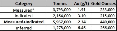
Granada Presents Updated High-Grade Mineral Resource Estimate
Granada Gold Mine Inc. (TSXV: GGM) (the “Company” or “Granada”) is pleased to provide an updated High-Grade Mineral Resource Estimate of the Granada Gold Deposit using narrow, rich, vein modelling and both open pit and underground resources and revised pit optimization parameters which are based on the possibility of off-site custom milling ore rather than constructing and using an on-site mill.
The National Instrument 43-101 Technical Report, including the updated mineral resources for Granada contained in this news release, is currently being completed by SGS and will be delivered and filed on SEDAR by GGM within 45 days. The objective of the SGS assignment is to update the MRE using the available data as of December 15, 2020. The goal is to present resources with both open pit potential and underground potential. Also, gold prices have evolved significantly since the 2019 MRE and that has helped the MRE presented here.
The updated MRE focused on using a scenario with higher cut-off grades than that used in the 2019 MRE. Gold price used is 1600 US$/oz.
Table 1 Updated Mineral Resource Estimate Base Case
| 1. | The 1930-1935 production was removed from these numbers (164,816 tonnes at 9.7 g/t Au / 51,400 ounces Au) |
| 2. | The Independent QP for this resources statement is Yann Camus, Eng., SGS Canada Inc. |
| 3. | The effective date is December 15, 2020 |
| 4. | CIM (2014) definitions were followed for Mineral Resources |
| 5. | Mineral resources which are not mineral reserves do not have demonstrated economic viability. An Inferred Mineral Resource has a lower level of confidence than that applying to a Measured and Indicated Mineral Resource and must not be converted to a Mineral Reserve. It is reasonably expected that the majority of Inferred Mineral Resources could be upgraded to Indicated Mineral Resources with continued exploration |
| 6. | No economic evaluation of the resources has been produced |
| 7. | All figures are rounded to reflect the relative accuracy of the estimate. Totals may not add due to rounding |
| 8. | Composites have been capped where appropriate. |
| 9. | Cut-off grades are based on a gold price of US$1,600 per ounce, a foreign exchange rate of US$0.76 for CA$1, a gold recovery of 93% |
| 10. | Pit constrained mineral resources are reported at a cut-off grade of 0.9 g/t Au within a conceptual pit shell |
| 11. | Underground mineral resources are reported at a cut-off grade of 3.0 g/t Au within reasonably mineable volumes |
| 12. | A fixed specific gravity value of 2.78 g/cm3 was used to estimate the tonnage from block model volumes |
| 13. | There are no mineral reserves on the Property |
| 14. | The 2.5 m composites were capped at 21 g/t Au in the thin rich veins and at 7 g/t Au in the low-grade volumes |
| 15. | The deepest resources reported are at a depth of 760 m |
| 16. | SGS is not aware of any known environmental, permitting, legal, title-related, taxation, socio-political, marketing or other relevant issues that could materially affect the mineral resource estimate. |
Revised Parameters
Table 1 General Parameters Used for the Mineral Resource Estimate Update
| Parameter | Value | Unit |
| Gold Price | 1600 | US$ per oz |
| Exchange Rate | 0.76 US$ : 1 CA$ | |
| Pit Slope | 50 | Degrees |
| Open Pit Mining Cost | 6.00 | CA$ per tonne mined |
| Underground Mining Cost | 105.00 | CA$ per tonne mined |
| Processing, Transportation Cost and G&A | 35.00 | CA$ per tonne milled |
| Gold Recovery | 93 | Percent (%) |
| Open Pit and Underground Mining loss / Dilution | 10 / 20 | Percent (%) / Percent (%) |
| Open Pit Cut-off Grade | 0.9 | g/t Au |
| Underground Cut-off Grade | 3.0 | g/t Au |
About the Mineral Resource Estimate
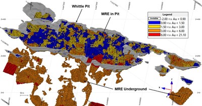
New drilling was achieved by GoldMinds Geoservices in 2020. While some of the results were still pending, SGS was mandated to create an updated resource estimation that shows both the potential for open pit resources and underground resources. In order to do that, the individual thin, rich veins had to be modelled individually. These veins are quite continuous (over distances of 800 m in strike and 900 m down dip). Mineralization is open at depth and on strike. The maximum distance between linked intervals is currently about 150 m. Some gaps of about 300 m have no drilling but should contain mineralization given the continuous nature of the deposit.
The database used for this mineral resource estimate includes drill results obtained from drill programs in 2009, 2010, 2011, 2012, 2016, 2017, 2018, 2019, 2020 and trenches from 2014 and 2015 plus many of the historic holes (1990’s).
The thin, rich veins were modelled as a first step in the estimation process. A grade of 0.7 g/t over a length of 2.5 m was used as a minimum. While the 2.5 m constraint was always met, some intervals were considered under 0.7 g/t to allow to model continuous mineralized structures. We estimate that the final 56 thin, rich veins modelled contain 88% of the gold from intervals that meet the 0.7 g/t over 2.5 m criteria.
A large, low-grade zone was modelled around all intervals containing significant gold. This large, low-grade volume is similar in shape and size to the previous resource model.
Composites of 2.5 m were created inside the thin, rich veins and in the low-grade volume. All resulting 57 volumes were estimated as hard boundaries. The rich, thin vein composites were capped at 21 g/t. It has a similar impact on gold content as the previous estimate capping methodology. The low-grade composites were capped at 7 g/t.
A block model was created with blocks of 5 x 2.5 x 2.5 m to fill the rich, thin veins while using block centers as indicators for the block’s nature. Both the kriging and inverse square distance estimation methods were tested with very similar results globally. The kriging is more conservative in grade and gold content once we apply the cut-off grades to report resources. Kriging was retained as the estimation method of choice for this project. Search ellipsoids used for the estimation are of 30 x 30 x 7.5 m, 60 x 60 x 15 m and 100 x 100 x 30 m respectively. A minimum of a single drillhole is needed to estimate blocks inside thin, rich veins. A minimum of 2 drillholes are needed to estimate blocks in the low-grade volume. Search ellipsoid orientations are variable depending on local orientation of the model.
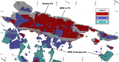
The classification in measured, indicated and inferred was done as a separate step with an algorithm with ellipsoids centered on composites. A drilling grid with a minimum of 3 drillholes within 30 m of each other or less defines measured resources (under 25 m most of the time) and a drilling grid with a minimum of 3 drillholes within 60 m of each other or less defines indicated resources (under 50 m most of the time). Measured resource extends only by 20 m around drillholes and indicated extends only by 40 m.
The mineral resource statement EXCLUDES the historical production of 51,476 ounces of gold (181,744 Tons @ 0.28 oz/Ton Au) from 1930 to 1935. These numbers were subtracted from the measured resources in the whittle open pit.
The supporting NI 43-101 Technical Report will be posted on SEDAR at www.sedar.com no later than 45 days after the date of this release.
All information pertaining to the resource estimates has been reviewed for accuracy and compliance under National Instrument 43-101 by Yann Camus, P.Eng., SGS Canada Inc. and Qualified Person.
Mineral Resource Estimate Details
The following tables show the separation of resources between the open pit portion and the underground portion of it.
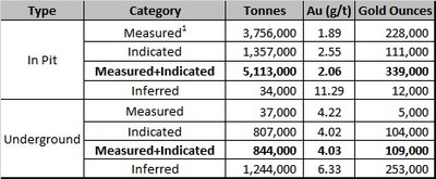
| Same footnotes as Table 1 apply to this table. |
Earlier this year, (Granada Gold Mine Press Release, August 11, 2020) the Company processed by conventional gravity concentration, a large 1220-kilogram grab sample taken over a 3-meter strike length in this stripped area, resulting in the recovery of 55.6 g/t native gold where the native gold component has been defined, for the Granada Gold Mine, to represent an average of 50% of the recoverable gold (43-101 Technical Report dated February 13, 2019 on the Granada Gold Project Mineral Resource Estimate, Rouyn Noranda, Quebec authored by the Qualified persons, Allan Armitage, Ph. D.., P. Geo and Maxime Dupere, B.SC., Geo both of SGS Canada Inc. – Section 13.1). The gold-bearing sulphides were not recovered.
“This updated High-Grade Mineral Resource shows the Granada deposit has the potential for extensive custom milling as well as for an on-site mill. The current mineral resource was derived from near-surface drilling over 2 kilometers of an east-west 5.5-kilometer mineralized structure. Exploratory drilling to the north, near the Cadillac Break has encountered high-grade mineralization at a vertical depth of 1100 meters. Mineralization is open at depth and on strike. The company is targeting 2.5 to 3 million ounces with the current 120,000-meter drill program building on the existing 120,000 metres drilled to increase the density of holes on the property.” said Frank J. Basa, P.Eng., President and CEO, “We are also fully permitted and shovel-ready as a shipper of ore to any local mill.”
Qualified person
The technical information in this news release has been prepared by Yann Camus, P.Eng., independent qualified person of SGS and was reviewed by Claude Duplessis, P.Eng., GoldMinds Geoservices Inc. member of Québec Order of Engineers and a qualified person in accordance with National Instrument 43-101 standards.
About Granada Gold Mine Inc.
Granada Gold Mine Inc. continues to develop the Granada Gold Property near Rouyn-Noranda, Quebec. Approximately 120,000 meters of drilling has been completed to date on the property, focused mainly on the extended LONG Bars zone which trends 2 kilometers east-west over a potential 5.5 kilometers of mineralized structure. The highly prolific Cadillac Break, the source of more than 75 million plus ounces of gold production in the past century, cuts through the north part of the Granada property, but is not necessarily indicative of mineralization hosted on the company’s property.
The Granada Shear Zone and the South Shear Zone contain, based on historical detailed mapping as well as from current and historical drilling, up to twenty-two mineralized structures trending east-west over five and a half kilometers. Three of these structures were mined historically from two shafts and two open pits. Historical underground grades were 8 to 10 grams per tonne gold from two shafts down to 236 m and 498 m with open pit grades from 5 to 3.5 grams per tonne gold.
The Company is in possession of all mining permits required to commence the initial mining phase, known as the “Rolling Start”, which allows the company to mine up to 550 tonnes per day. Additional information is available at www.granadagoldmine.com.
“Frank J. Basa”
Frank J. Basa P. Eng.
President and Chief Executive Officer
Neither the TSX Venture Exchange nor its Regulation Service Provider (as that term is defined in the policies of the TSX Venture Exchange) accepts responsibility for the adequacy or accuracy of this release. This news release may contain forward-looking statements including but not limited to comments regarding the timing and content of upcoming work programs, geological interpretations, receipt of property titles, potential mineral recovery processes, etc. Forward-looking statements address future events and conditions and therefore, involve inherent risks and uncertainties. Actual results may differ materially from those currently anticipated in such statements.
SOURCE Granada Gold Mine Inc.


View original content to download multimedia: http://www.newswire.ca/en/releases/archive/January2021/29/c0309.html
Contact:
Frank J. Basa, P. Eng., President and CEO at 1-819-797-4144 or Wayne Cheveldayoff, Corporate Communications, at 416-710-2410 or waynecheveldayoff@gmail.com
- Published in Granada Gold Mine, Mining, News Home
Lake Winn Obtains the Quartz Project in Manitoba, with Historic Gold Intercepts
Lake Winn Resources Corp. (“Lake Winn” or the “Company”) (TSXV:LWR) (OTC:EQTXF) has obtained a new 100% owned gold project in the Flin Flon gold belt, Manitoba. The project was obtained in part by staking and in part by completing a purchase agreement described below.
The Quartz project lies near the southern shores in Reed Lake between the Reed Lake and Four Mile Island VMS deposits.
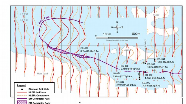
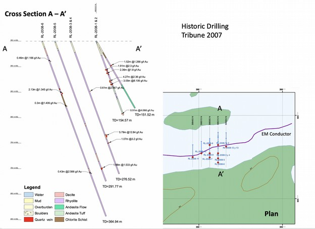
The Quartz project contains multiple drill hole intercepts containing gold. See Tables 1, 2, 3, and 4 below. In 1975, diamond drill hole Eel-258, intersected 1.28m @ 19.9 g/t Au, whilst targeting a 1.45 km long EM conductor. The hole was drilled by Hudson Bay Exploration and Development Co. Ltd. (“Hudson Bay”) who were exploring for copper-zinc massive sulphide deposits at the time. Subsequently, Hudson Bay drilled 19 diamond drill holes into this gold bearing zone between 1975 and 1988. 14 of the 19 holes were drilled in 200m long sections of the conductor, leaving most of the 1.45 km long conductor untested. Figure 1 depicts the location of the Hudson Bay drill holes and the drill hole intercepts. In 2007 the area was further drill tested by Tribune Uranium Corp., (“Tribune”). Their work is summarized in Table 2. They also encountered multiple gold intercepts but again they concentrated the drilling in the 200m zone already shown to contain gold by Hudson Bay. Highlights of the Tribune drilling include 5.8m @ 12.8g/t Au, and 1.43m @ 12.0 g/t Au. The drill intercepts show that the conductor is represented by a shear with sulphides and graphite hosted in felsic volcanics. The Tribune drilling intersected multiple gold bearing shears and a cross section is provided in figure 2 to demonstrate this.
Lake Winn’s main exploration objective is to drill test the entire 1.45 km length of the conductor for extensions of the proven zone which is defined by the historic drilling open to the east, to the west, and at depth. To expedite this the company has commissioned a heliborne time domain EM survey (TDEM). This survey will be used to accurately locate the conductive horizon, allowing 3D modeling of the conductor to aid drill targeting. The plan is to begin drilling before the ice melts prior to April depending on permitting and the weather. Permit applications have been submitted.
Table 1: Hudson Bay Gold Drill Hole Locations.
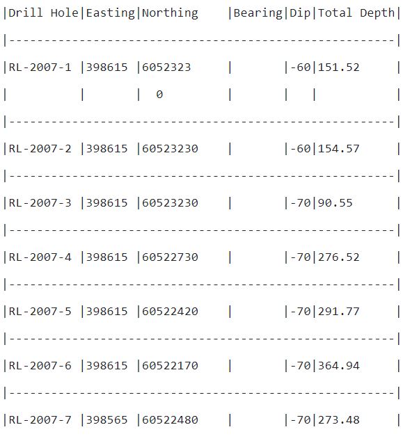
Table 2: Hudson Bay Gold Intercepts
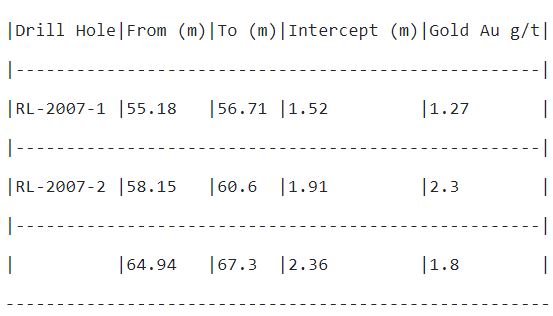
Table 3: Tribune, 2007 Drill Collar Locations and Orientation
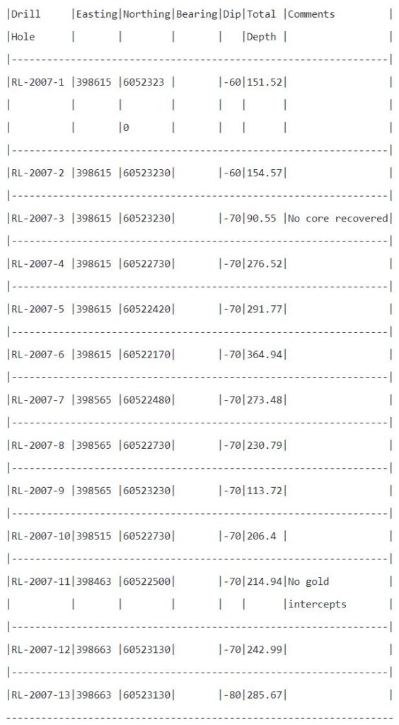
Table 4: Gold Intercepts >1 g/t Tribune Holes.

Click Image To View Full Size
Figure 2 Tribune historic 2007 drilling, plan and cross section.
Transaction
Lake Winn will pay William Ferreira, $50,000 and 100,000 shares for the 100% purchase of the Quartz Claims, named Quartz 1 and Quartz 2 totaling 254 hectares, along with granting a 2% Gross overriding Royalty (“GOR”) of which 1% may be purchased for $1 million. The transaction is subject to TSX approval. The company has spent approximately $30,000 staking 100% owned ground around these core claims, totaling approximately 5,000 hectares, to create an exploration buffer around the core. The Royalty will apply to a portion of this ground in an area of interest.
Qualified Person
The Qualified Person for this news release is Buddy Doyle, AUSIMM, a Geologist with over 30 years’ experience in mineral exploration, discovery, and evaluation. A Qualified Person under the provisions of National Instrument 43-101. There has been no site visit as the property is under a lake. Efforts have been made to locate the historic core which will be viewed when located and Covid restriction allow.
About Lake Winn
Lake Winn Resources Corp., is a Vancouver based gold company, listed on the TSX Venture Exchange (Symbol: LWR) focusing on exploration and development of gold projects in Canada. The company’s flagship property, the Cloud Project is in the province of Manitoba, in the Flin Flon Gold Belt approximately 40 kilometers north‐east of the town of Flin‐Flon. Access to the property is provided by Manitoba highway 10 to the all‐weather Kississing Lake Road. The company is currently diamond drilling on this property. The company now has a second gold property in Manitoba, the Quartz project in Reed Lake reported in this release.
On Behalf of the Board of Directors of Lake Winn Resources Corp.
Patrick Power, President & CEO
+1 (604) 218-8772
- Published in Lake Winn Resources, Mining, News Home
Granada Gold Hits 3.43 g/t Gold Over 20.5 Meters Near Surface and 6.45 g/t Over 4.5 Meters and 7.9 g/t Over 3 Meters
Granada Gold Mine Inc. (TSXV: GGM) (the “Company” or “Granada”) is pleased to provide another update on its continuing drill program at Granada. This release contains drill results from the 100-series, part 3, near-surface drill program targeting Vein 1. The program is progressing as expected with the intention of converting the current low-grade open pit resource at 1 gram per tonne to a smaller, higher grade open pit with the majority of the future potential ounces in a resource underground. The company has now increased the drill program to 18,000 meters with a target of 120,000 meters to be drilled.
Highlights:
- 7.9 g/t gold over 3.0m in hole GR-20-121 from 15.0 to 18.0m
- 6.45 g/t gold over 4.5m in hole GR-20-122 from 0.0 to 4.5m
- 3.43 g/t gold over 20.5m in hole GR-20-126 from 0.0 to 20.5m
Frank J. Basa, P.Eng., President and CEO notes, “The short-hole drill program has been successful and the company will begin with a new 200-series program with the objective of identifying deeper, down-dip, near-surface mineralization to develop a higher-grade open pit. The current program has been focused on an over 500 meters east-west strike length of a potential 5.5 kilometers mineralized strike length.”
ASSAY RESULTS
| Hole ID | From (m) | To (m) | Length (m) | Gold (g/t) |
| GR-20-121 | 0.00 | 9.00 | 9.00 | 0.45 |
| and | 15.00 | 18.00 | 3.00 | 7.90 |
| including | 15.00 | 16.50 | 1.50 | 15.65 |
| GR-20-122 | 0.00 | 10.50 | 10.50 | 3.25 |
| including | 0.00 | 4.50 | 4.50 | 6.45 |
| and | 67.50 | 78.00 | 7.00 | 0.66 |
| and | 87.35 | 91.45 | 4.10 | 3.06 |
| including | 88.85 | 91.45 | 2.60 | 4.46 |
| GR-20-126 | 0.00 | 20.50 | 20.50 | 3.43 |
| including | 11.00 | 13.00 | 2.00 | 4.12 |
| including | 16.00 | 18.00 | 2.00 | 14.9 |
Lengths are core length, no capping applied. Au is Gold by Fire assay, or by gravimetric finish or screen metallic method. Other assays results are still pending. As the Company is being impacted by longer than expected turnaround time (TAT) of analytical results due to COVID-19 and extensive workloads at the ALS laboratory the Company has decided to send the next samples to SGS laboratories to shorten the time frames.
The 100-series holes were drilled to intersect the vein uncovered by stripping and to follow the high-grade corridor. Holes GR-20-118 to GR-20-125 are vertical holes drilled to intersect the mineralized vein structures and Hole GR-20-126 is drilled within the vein structure.
Typical true thickness of the number 1 vein is 1.5 to 6.0 meters. The halo effect around vein 1 has been measured up to 20 meters true thickness with numerous mineralized veinlets hosting native gold. It has been estimated, based on metallurgical testing, that close to 50 percent of the gold is in native form and can be recovered from these veinlets.
Current Drilling
Drilling continues with two drills remaining on site at Granada. The goal is to complete 6000-meter drill program intervals with the objective of targeting 120,000 meters. The current program is focused on exploration on only 20 percent of the entire potential 5.5-kilometre mineralized structure.
Qualified person
The technical information in this news release has been reviewed by Claude Duplessis, P.Eng., GoldMinds Geoservices Inc. member of Québec Order of Engineers and a qualified person in accordance with National Instrument 43-101 standards.
Quality Control and Reporting Protocols
All NQ core assays reported were obtained by either 1-kilogram screen fire assay or standard 50-gram fire-assaying-AA (Atomic Absorption) finish or gravimetric finish at ALS Laboratories in Val d’Or, Québec, Thunder Bay, Ontario, Sudbury, Ontario or Vancouver, British Columbia. The screen assay method is selected by the geologist when samples contain visible gold. The drill program, Quality Assurance/Quality Control (“QA/QC”) and interpretation of results is performed by qualified persons employing a QA/QC program consistent with NI 43-101 and industry best practices. Standards and blanks are included with every 20 samples for QA/QC purposes for this program in addition to the lab QA/QC.
About Granada Gold Mine Inc.
Granada Gold Mine Inc. continues to develop the Granada Gold Property near Rouyn-Noranda, Quebec. Approximately 120,000 meters of drilling has been completed to date on the property, focused mainly on the extended LONG Bars zone which trends 2 kilometers east-west over a potential 5.5 kilometers of mineralized structure. The highly prolific Cadillac Break, the source of more than 75 million plus ounces of gold production in the past century, cuts through the north part of the Granada property but is not necessarily indicative of mineralization hosted on the Company’s property.
Pit-Constrained Mineral Resources at Granada disclosed on February 13th, 2019 Press Release prepared by SGS independent QP Maxime Dupéré Geo. & Allan Armitage P. Geo “Technical Report on the Granada Gold Project Mineral Resource Estimate, Rouyn-Noranda, Quebec, Canada” stand at:
| Category | Tonnes | Grade (g/t AU) | Contained Gold (oz.) |
| Measured | 12,637,000 | 1.02 | 413,000 |
| Indicated | 9,630,000 | 1.13 | 349,000 |
| Measured & Indicated | 22,267,000 | 1.06 | 762,000 |
| Inferred | 6,930,000 | 2.04 | 455,000 |
Mineral resources which are not mineral reserves do not have demonstrated economic viability. An Inferred Mineral Resource has a lower level of confidence than that applying to a Measured and Indicated Mineral Resource and must not be converted to a Mineral Reserve. It is reasonably expected that the majority of Inferred Mineral Resources could be upgraded to Indicated Mineral Resources with continued exploration.
* Pit constrained mineral resources are reported at a cut-off grade of 0.4 g/t Au within a conceptual pit shell.
The Granada Shear Zone and the South Shear Zone contain, based on historical detailed mapping as well as from current and historical drilling, up to twenty-two mineralized structures trending east-west over five and half kilometers. Three of these structures were mined historically from two shafts and two open pits. Historical underground grades were 8 to 10 grams per tonne gold from two shafts down to 236 m and 498 m with open pit grades from 5 to 3.5 grams per tonne gold.
The Company is in possession of all mining permits required to commence the initial mining phase, known as the “Rolling Start”, which allows the company to mine up to 550 tonnes per day. Additional information is available at www.granadagoldmine.com.
“Frank J. Basa”
Frank J. Basa P. Eng.
President and Chief Executive Officer
Neither the TSX Venture Exchange nor its Regulation Service Provider (as that term is defined in the policies of the TSX Venture Exchange) accepts responsibility for the adequacy or accuracy of this release. This news release may contain forward-looking statements including but not limited to comments regarding the timing and content of upcoming work programs, geological interpretations, receipt of property titles, potential mineral recovery processes, etc. Forward-looking statements address future events and conditions and therefore, involve inherent risks and uncertainties. Actual results may differ materially from those currently anticipated in such statements.
SOURCE Granada Gold Mine Inc.


View original content to download multimedia: http://www.newswire.ca/en/releases/archive/January2021/27/c3415.html
Contact:
Frank J. Basa, P. Eng., President and CEO at 1-819-797-4144 or Wayne Cheveldayoff, Corporate Communications, at 416-710-2410 or waynecheveldayoff@gmail.com
- Published in Granada Gold Mine, Mining, News Home
Downhole Geophysics Completed on Visually High-Grade Silver Vein Intersected at Robinson Zone
Canada Silver Cobalt Works Inc. (TSXV: CCW) (OTCQB: CCWOF) (Frankfurt: 4T9B) (the “Company” or “Canada Silver Cobalt”) is pleased to announce the completion of a hole-to-hole IP study earlier this month. The study was conducted on the newly discovered, visually high-grade silver vein intersected in hole CS-20-39.
Highlights
- Down hole Geophysics was conducted from January 4th -12th 2021.
- The holes used for the hole-to-hole pairing contained zones of cobalt and silver veining.
- Encouraging results delineated a good response over the 17m mineralized zone.
This study produced testable results that are being investigated by wedge drilling that is now underway. The team is working closely with the geophysicists to interpret results from the initial wedging while a more comprehensive action plan is being developed to delineate new targets in areas where we have already qualified the need for enhanced resolution of existing veins. This initiative will also open up new ground.
A larger geophysical project is also in development that will utilize the Distributed Array System, “DasVision” which will incorporate a bigger geographic area. It is anticipated the study will lead to injecting current in both boreholes and at surface in order to provide better resolution at depth.
Matt Halliday, President commented, “The Company is taking full advantage of new geophysical techniques while maximizing the utility of existing technologies. As the technical team continues to advance and better understand this deposit model, we will have a comprehensive toolbox to facilitate the generation of the best possible targets. New IP techniques will be part of this toolbox that will also include advanced cameras, structural technology including oriented core and directional drilling, and various geochemistry techniques.”
Location
The Castle Property is 15 km east of Pan American Silver’s Juby gold deposit, 30 km due south of Alamos Gold’s Young-Davidson mine, 75 km southwest of Kirkland Lake Gold’s Macassa Complex, and 100 km southeast of new gold discoveries in the Timmins West area.
Qualified Person
The technical information in this news release was prepared under the supervision of Mr. Matthew Halliday, P.Geo., (APGO) President of Canada Silver Cobalt Works Inc., a qualified person in accordance with National Instrument 43-101.
About Canada Silver Cobalt Works Inc.
Canada Silver Cobalt Works released the first-ever resource in the Gowganda Camp and greater Cobalt Camp. In May 2020. A total of 7.56 million ounces of silver in Inferred resources comprising very high-grade silver (8,582 grams per tonne un-cut or 250.2 oz/ton) in 27,400 tonnes of material from two sections (1A and 1B) of the Robinson Zone beginning at a vertical depth of approximately 400 meters. The discovery remains open in all directions (1A and 1B are approximately 800 meters from the east-trending Capitol Mine workings) (mineral resources that are not mineral reserves do not have demonstrated economic viability) (refer to Canada Silver Cobalt Works Press Release May 28, 2020. Report reference: Rachidi, M. 2020, NI 43-101 Technical Report Mineral Resource Estimate for Castle East, Robinson Zone, Ontario, Canada, with an effective date of May 28, 2020 and a signature date of July 13, 2020.
Canada Silver Cobalt’s flagship Castle mine and 78 sq. km Castle Property features strong exploration upside for silver, cobalt, nickel, gold, and copper in the prolific past producing Gowganda high-grade Silver District of Northern Ontario. With underground access at Castle, a pilot plant to produce cobalt-rich gravity concentrates on site, a processing facility (TTL Laboratories) in the town of Cobalt, and a proprietary hydrometallurgical process known as Re-2OX for the creation of technical grade cobalt sulphate as well as nickel-manganese-cobalt (NMC) formulations, Canada Silver Cobalt is strategically positioned to become a Canadian leader in the silver-cobalt space.
“Frank J. Basa”
Frank J. Basa, P. Eng.
Chief Executive Officer
Neither the TSX Venture Exchange nor its Regulation Service Provider (as that term is defined in the policies of the TSX Venture Exchange) accepts responsibility for the adequacy or accuracy of this release. This news release may contain forward-looking statements including but not limited to comments regarding the timing and content of upcoming work programs, geological interpretations, receipt of property titles, potential mineral recovery processes, etc. Forward-looking statements address future events and conditions and therefore, involve inherent risks and uncertainties. Actual results may differ materially from those currently anticipated in such statements.
SOURCE Canada Silver Cobalt Works Inc.


View original content: http://www.newswire.ca/en/releases/archive/January2021/26/c6033.html
Contact:
Frank J. Basa, P.Eng., Chief Executive Officer, 416-625-2342
- Published in Canada Cobalt Works, Mining, News Home
Newlox Resumes Pouring Gold
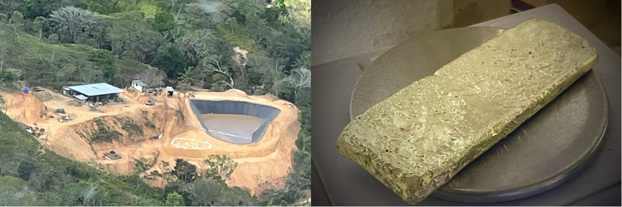
Figure 1. Newlox Gold’s Upgraded Plant and Most Recent Gold Doré Bar
Vancouver, BC – TheNewswire – 21 January 2021 – Newlox Gold Ventures Corp. (“Newlox” or the “Company”) (CSE: LUX ) (CSE:LUX.CN) ( Frankfurt/Stuttgart: NGO ) is pleased to announce that pouring of gold at the Company’s first environmentally positive processing plant in Costa Rica has recommenced. Newlox Gold poured its first gold doré for 2021, and the operations team plan to regularly pour gold for sale as operations ramp-up to full scale over the coming months.
Gold production at Plant 1 was re-started following the unavoidable Covid-19 suspension of operations earlier in 2020. During that time, Newlox took advantage of the situation to move its first processing plant to a more favourable permanent location in line with longer-term growth objectives.
The Company is now operating a significantly enhanced processing plant, which is expected to achieve full-scale throughput at 80 tonnes per day in the second quarter of 2021. Recoveries to date have established a feedstock cutoff grade of 9 grams per tonne gold and recoveries of approximately 90%. Management looks forward to increased precious metals production and sales over the coming quarters.
Click here to register for Newlox’s bi-weekly conference call to learn more.
A Message from Ryan Jackson, President & CEO:
“We are pleased to pour our first gold doré of 2021, which is a milestone on the path to full-scale production at Plant 1. This first pour at our upgraded plant indicates the technical systems are operating well and ready to scale.
Now the focus is on ramping-up daily throughput and reaching the Company’s production goals. Having closed a major financing for the company in December, Newlox Gold has a strong financial footing, which is supporting the ramp-up of operations at Plant 1 as well as the advancement of the Company’s growth strategy.”
About Newlox Gold
Newlox has identified a niche within the extractive industry where a clean-technology company can apply innovative processing techniques to not only recover precious metals but also affect positive change in the environmental and social landscape in its targeted jurisdictions of operations.
Forward-Looking Information
The information in this news release includes certain information and statements about management’s view of future events, expectations, plans and prospects that constitute forward-looking information. Forward-looking information includes, but is not limited to, the completion of the work programs currently underway and the results of these programs. These statements are based upon assumptions that are subject to significant risks and uncertainties. Because of these risks and uncertainties and as a result of a variety of factors, the actual results, achievements, or performance may vary materially from those anticipated and indicated by these forward-looking statements. The material risk factors that could cause actual results to differ include the risk that work undertaken by the Company may have unintended effects, the risk of delays in completing work, and the risk that the Company may not be able to raise sufficient funds and Force Majeure. Although the Company believes that the expectations reflected in the forward-looking information are reasonable, it can give no assurances that the expectations of any forward-looking information will prove to be correct. Except as required by law, the Company disclaims any intention and assumes no obligation to update or revise any forward-looking information to reflect actual results, whether as a result of new information, future events, changes in assumptions, changes in factors affecting such forward-looking statements or otherwise. Neither Canadian Securities Exchange nor its Regulation Services Provider (as that term is defined in the policies of the Canadian Securities Exchange) accept responsibility for the adequacy or accuracy of this release).
Technical Disclaimer
The Company advises it is not basing any decision to produce on a feasibility study of reserves demonstrating the economic and technical viability of the project and also advises there is increased uncertainty and specific economic and technical risks of failure associated with any production decision. Stewart A. Jackson, Ph.D., P.Geo., a “Qualified Person” within the meaning of National Instrument 43-101, has prepared, supervised the preparation of, and approved the contents of this News Release.
On Behalf of the Board, Newlox Gold Ventures Corp.
Contact Newlox Gold
Ryan Jackson
Newlox Gold Ventures Corp., President
Website: www.newloxgold.com
Email: ryan@newloxgold.com
Phone: +1 778 738 0546
- Published in Mining, Newlox Gold, News Home
Sun Summit Outlines Plans for Upcoming Drill Program at Buck: Identifies New Drill Targets
Sun Summit Minerals Inc. (TSXV: SMN) (OTC: SMREF) (“Sun Summit” or the “Company”) is pleased to announce the start of a significant drill program at the Buck Property, central British Columbia, in late January. Sun Summit plans to complete over 5,000 metres of drilling targeting high-grade gold mineralization.
Highlights
- Sun Summit will mobilize crews to commence an aggressive follow-up drill program to target high-grade gold mineralization near discovery hole BK20-012 (17 metres of 5.86 grams per tonne (g/t) gold including 3 metres of 23.05 g/t gold, and 7.5 metres of 10.19 g/t gold; SMN news release dated January 5th, 2021).
- Over 5,000 metres is planned for the first set of drill holes.
- A new property-scale exploration model defined by high-chargeability anomalies in relation to mineralized zones was used to identify numerous additional drill targets.
- Several holes are designed to test the gold mineralization potential of four newly identified chargeability anomalies.
Bob Willis, Sun Summit’s CEO, stated, “We are excited to commence another significant round of drilling at our Buck property. The primary objective for this drill program is to expand on high-grade gold zones discovered in our last phase of drilling. Our new 3D modelling of mineralized areas on the Buck property in relation to our 3D geophysical chargeability model is being used to spot new drill holes in areas we consider significant. Two untested chargeability anomalies are priority targets and will be a considerable focus. Over 5,000 metres of diamond drilling will be completed for initial planned holes, with additional drilling expected after initial drill hole assay results are received.”
Exploration Model
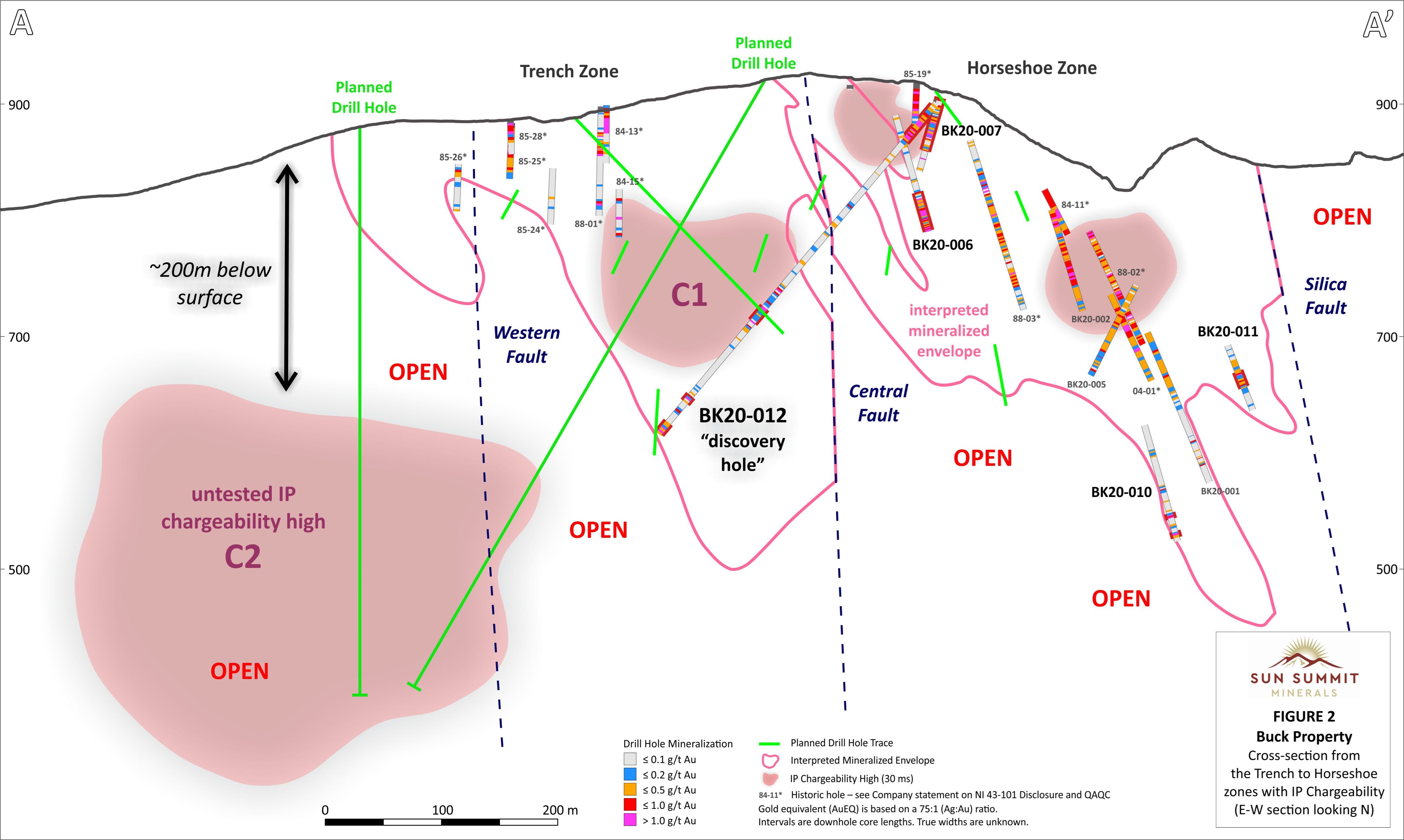
Based on new geological and structural mapping together with induced polarization (IP) geophysical data and downhole geochemical and lithological data, an updated and comprehensive exploration model for the property has been developed. Key to this model are data from the recently completed 3D IP survey (see SMN news release dated November 5th, 2020) and the location of chargeability anomalies in spatial relation to gold-bearing mineralized zones intersected in recent drilling (see SMN news release dated January 5th, 2021). High-chargeability anomalies are interpreted to represent zones of high-sulfide content, likely disseminated, as these minerals and textures may generate a strong IP-effect.
The 3D chargeability model is centered on a large >30 millisecond anomaly interpreted to have been faulted and offset by a series of north-south trending normal faults (Figure 1). From east to west the faults are known as Silica, Central and West faults. Due to widespread overburden on the western side of the property, the locations of these post-mineralization faults are also largely based on interpreted offsets of mineralised quartz-feldspar porphyritic dykes intersected in previous drill holes and on the spatial extent of multi-element soil geochemical anomalies (Figure 1).

To view an enhanced version of Figure 1, please visit:
https://orders.newsfilecorp.com/files/6142/72296_6835baa8b484e836_001full.jpg
The easternmost, near-surface, chargeability anomaly spatially correlates with gold-bearing sulfide-cemented breccias intersected in the top of numerous drill holes (e.g., BK20-06, 46 metres of 1.12 g/t gold equivalent (AuEQ) including 24.7 metres of 1.69 g/t AuEQ). This anomaly is offset on its western margin and down-dropped 100 metres by the Central fault where it measures approximately 400 by 230 by 180 metres. The high-grade intervals in discovery hole BK20-012 spatially correlate with the bottom of the untested C1 anomaly (Figure 2). The western extent of the C1 anomaly is interpreted to have been offset and down-dropped by the Western fault where an elongate 650 by 350 by 300 metre chargeability anomaly (C2) is observed with its top approximately 200 metres below surface. This significant >30 millisecond chargeability anomaly is untested and represents a priority target.
To view an enhanced version of Figure 2, please visit:
https://orders.newsfilecorp.com/files/6142/72296_6835baa8b484e836_002full.jpg
Figure 2 shows an east-west cross section from the eastern Horseshoe zone to the western C2 anomaly, a distance of approximately 750 metres. Selected planned drill holes are plotted on the cross section as well as pierce-points of planned drill holes projecting into the cross section to highlight the focus of the upcoming drill program. These drill holes are designed to test the gold mineralization potential of the C1 and C2 anomalies. Numerous additional holes are planned to test the areas between the anomalies as well as the mineralization potential below the anomalies. Many holes bottomed in pervasively altered and locally mineralized volcanic rocks (e.g., BK20-012) suggesting the epithermal-related system is open at depth.
Additional untested chargeability anomalies are observed. Anomaly C3 is approximately 400 metres southwest of the Horseshoe Zone and anomaly C4 is approximately 900 metres northwest of the Horseshoe zone (Figure 1). Multiple drill holes are also planned to test these anomalies.
Drill Program
The upcoming drill program is designed with three primary objectives:
- Target high-grade gold mineralization peripheral to discovery hole BK20-012 (e.g., BK20-012, 17 metres of 5.86 g/t gold including 3 metres of 23.05 g/t gold, and 7.5 metres of 10.19 g/t gold (see SMN news release dated January 5th, 2021). Multiple drill holes are planned to investigate the extent of high-grade gold mineralization between the Trench and Horseshoe zones.
- Test chargeability anomalies interpreted to be associated with sulfide and potential gold mineralization. Multiple drill holes are designed to test the centres and margins of three significant chargeability anomalies (C1, C2, and C3) identified in a recent 3D IP survey.
- Investigate the strike extent of sulfide-cemented breccia-hosted mineralization (e.g., BK20- 006, 46 metres of 1.12 g/t AuEQ including 24.7 metres of 1.69 g/t AuEQ (see SMN news release dated January 5th, 2021). Multiple drill holes are planned to further test the near-surface, bulk-tonnage gold potential of the Horseshoe Zone.
Geological crews have been mobilised to the property to re-log key drill holes from Phase 2 drilling and to survey new drill pads in preparation for the arrival of drill crews later this month.
Induced Polarization Survey
The 2 by 2.5 kilometre IP survey was conducted by SJ Geophysics Ltd. in September and October 2020 using the Volterra-3D IP 5 line Acquisition System. The 20 line kilometre survey was conducted on 200 metre spaced north-south lines. Further technical details on the instrumentation and acquisition settings employed at Buck can be found at https://www.sjgeophysics.com/.
Buck Property
The recently expanded 33,000 hectare property, approximately 12 kilometres south of Houston, British Columbia, has excellent nearby infrastructure and allows for year-round road-accessible exploration.
National Instrument 43-101 Disclosure
This news release has been approved by Sun Summit’s CEO, Robert D. Willis, P. Eng. a “Qualified Person” as defined in National Instrument 43-101, Standards of Disclosure for Mineral Projects of the Canadian Securities Administrators. He has also verified the data disclosed, including sampling, analytical and test data, underlying the technical information in this news release.
Some data disclosed in this news release (e.g., Figure 2) relating to sampling and drilling results is historical in nature. Neither the Company nor a qualified person has sufficiently verified this data, and therefore, investors should not place undue reliance on such data.
Health and Safety
The Company’s exploration programs are being carried out in full compliance with federal, provincial, and municipal guidelines established in response to the global COVID-19 pandemic. Sun Summit has a rigorous infection prevention and control protocol in place to protect the health of employees and contractors, as well as surrounding communities in which the Company works.
About Sun Summit
Sun Summit Minerals Corp. (formerly San Marco Resources Inc.) is a Canadian mineral exploration company actively pursuing world class gold and silver projects with a focus in mining friendly jurisdictions.
The Company’s principal focus is the Buck Property in north-central British Columbia that has bulk-tonnage gold and silver potential. The property is located in a mining-friendly region that includes many former and current operating mines.
Sun Summit is committed to environmental and social responsibility with a focus on responsible development to generate positive outcomes for all stakeholders.
Further details are available at www.sunsummitminerals.com
Link to Figures
Figure 1:
https://sunsummitminerals.com/wp-content/uploads/2021/01/Buck_Fig1_IP_Plan_Jan19_NR_v2-scaled.jpg
Figure 2:
https://sunsummitminerals.com/wp-content/uploads/2021/01/Buck_Fig2_IP_Section_Jan19_NR-scaled.jpg
For further information, contact:
Sharyn Alexander, M.Sc.
VP Technical Services
Nancy Curry
Corporate Communications
Tel. 778-588-9606
- Published in Mining, News Home, San Marco Resources