Sun Summit Continues to Intersect Multiple Zones of High-Grade and Bulk Tonnage-Style Gold Mineralization at Buck Property, Central BC
Sun Summit Minerals Inc. (TSXV: SMN) (OTC Pink: SMREF) (“Sun Summit” or the “Company”) is pleased to report additional results from its fully funded 2021 exploration program on its Buck Property, central B.C.
Highlights
Trench Zone
- BK21-024: Numerous high-grade intervals cut throughout the entire hole:
- 19.71 grams per tonne (g/t) gold equivalent (AuEQ) over 1.4 metres and 14.01 g/t AuEQ over 1.4 metres within 6.35 g/t AuEQ over 7.6 metres, and within a broader interval of 2.97 g/t AuEQ over 17.0 metres near the top of the hole.
- 42.05 g/t AuEQ over 1.0 metre within a broader interval of 5.84 g/t AuEQ over 7.4 metres from 252.6 metres down hole.
- 16.87 g/t AuEQ over 1.0 metre within a broader interval of 2.01 g/t AuEQ over 9.0 metres near the bottom of the hole.
- 19.71 grams per tonne (g/t) gold equivalent (AuEQ) over 1.4 metres and 14.01 g/t AuEQ over 1.4 metres within 6.35 g/t AuEQ over 7.6 metres, and within a broader interval of 2.97 g/t AuEQ over 17.0 metres near the top of the hole.
- BK21-026: Broad zones of bulk tonnage-style gold mineralization with local high-grade gold intercepts:
- 33.67 g/t AuEQ over 1.0 metres within a broader interval of 1.18 g/t AuEQ over 44.1 metres.
- 33.67 g/t AuEQ over 1.0 metres within a broader interval of 1.18 g/t AuEQ over 44.1 metres.
- BK21-025: Numerous broad zones of bulk tonnage-style gold mineralization:
- 9.28 g/t AuEQ over 1.0 metre within a broader interval of 0.64 g/t AuEQ over 39.0 metres from 123.0 metres down hole.
- 13.97 g/t AuEQ over 0.8 metres within a broader interval of 1.07 g/t AuEQ over 32.2 metres which is within a wider interval of 0.85 g/t AuEQ over 62.0 metres from deeper in the hole.
- 9.28 g/t AuEQ over 1.0 metre within a broader interval of 0.64 g/t AuEQ over 39.0 metres from 123.0 metres down hole.
Horseshoe zone
- BK21-032: Multiple broad zones of >1.0 g/t gold mineralization:
- 2.99 g/t AuEQ over 12.3 metres within a broader interval of 1.19 g/t AuEQ over 54.0 metres from 89.0 metres down hole.
- 1.46 g/t AuEQ over 31.0 metres within a broader interval of 0.95 g/t AuEQ over 59.1 metres from 192.0 metres down hole.
- 2.99 g/t AuEQ over 12.3 metres within a broader interval of 1.19 g/t AuEQ over 54.0 metres from 89.0 metres down hole.
Note: Intervals are downhole core lengths. True widths are unknown. AuEQ based on a 65:1 silver to gold ratio.
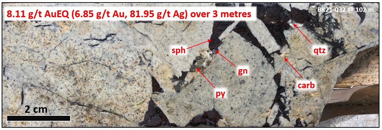
Figure 1. Photograph of sulfide-cemented breccias cut in BK21-032 at 102 metres down hole. Abbreviations: sph = sphalerite, py = pyrite, gn = galena, carb = carbonate, = qtz = quartz
To view an enhanced version of Figure 1, please visit:
https://orders.newsfilecorp.com/files/6142/87124_c0622daa6498cb72_001full.jpg
Sun Summit has drilled 18 holes in 2021. Results from the first five holes were released on May 11th, 2021. Results from six additional holes are reported in this news release (Tables 1 and 2). Results from seven holes from the Horseshoe and Trench zones and peripheral areas remain pending (Figures 2 and 3).
Bob Willis, Sun Summit’s CEO commented: “The 2021 drill program continues to deliver significant results in the Trench zone area that is quickly becoming a robust high-grade gold target. Like previously reported results, high-grade gold mineralization was intersected in multiple intervals in multiple holes in the Trench zone and confirms the potential of this target for vein-hosted high-grade gold. What is equally important is the new discovery that bulk tonnage-style disseminated gold mineralization is also present in the Trench zone.”
“We are also very pleased with results from the only hole reported here from the Horseshoe zone. This hole cut multiple zones of >1.0 g/t gold mineralization.”
“It is gratifying to report large cumulative gold intercepts in all holes, which were broadly spaced and drilled at multiple different azimuths. Trench to Horseshoe continues to be completely open for further expansion in all directions. Results from remaining drill holes will be released shortly.”
Trench zone
The five Trench zone holes (BK21-021, 023, 024, 025 and 026; Table 1) were designed to investigate the extent of multiple zones of high-grade gold mineralization discovered in BK20-012 (see news release dated January 5th, 2021) and confirmed in BK20-020 (see news release dated May 11th, 2021). Results from the Trench zone are reported in Table 1.
Table 1. Assay results – Trench zone
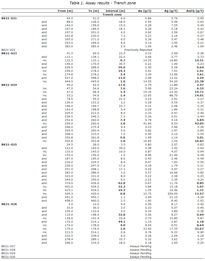
- AuEQ (gold equivalent) based on a 65:1 silver to gold (Ag:Au) ratio.
- Calculations are uncut and length-weighted using a 0.15 g/t gold cutoff with less than five continuous metres of internal dilution.
- Intervals are downhole core lengths. True widths are unknown.
BK21-024 and BK21-023 were drilled steeply to the south to test the extent of high-grade gold mineralization discovered in BK20-012.
BK21-024 intersected multiple intervals of high-grade gold mineralization throughout the entire hole (intervals are not true widths) including 19.71 g/t AuEQ over 1.4 metres, 14.01 g/t AuEQ over 1.4 metres, 42.05 g/t AuEQ over 1.0 metre, and 16.87 g/t AuEQ over 1.0 metre (Figure 3). The deepest high-grade interval at 352.8 metres downhole is approximately 70 metres below the bottom of BK20-012 which hit 7.54 g/t AuEQ over 1.0 metre within 1.05 g/t AuEQ over 12.7 metres (see news release dated January 5th, 2021). These high-grade intercepts in BK21-024 are locally within wider intervals of bulk-tonnage style mineralization such as 2.97 g/t AuEQ over 17.0 metres near the top of the hole from 45.0 to 62.0 metres (Table 1).
Similarly, BK21-023 intersected numerous broad intervals of bulk tonnage-style mineralization (e.g., 0.64 g/t AuEQ over 59.0 metres including 1.01 g/t AuEQ over 19.2 metres) highlighted by 15.38 g/t AuEQ over 1.0 metre within a broader interval of 2.29 g/t AuEQ over 11.0 metres near the bottom of the hole (Figure 3). BK21-026 was drilled to the east and hit multiple intervals of gold mineralization throughout the entire hole highlighted by 1.18 g/t AuEQ over 44.1 metres including 33.67 g/t AuEQ over 1.0 metres from 170.0 to 214.1 metres down hole.
The presence of broad zones of bulk tonnage-style, disseminated gold mineralization with internal local high-grade vein-hosted mineralization was also intersected in BK21-025, collared 150 metres east of BK21-026 and drilled to the east. The hole cut mineralization throughout the entire hole starting with 0.64 g/t AuEQ over 39.0 metres from 123.0 to 162.0 metres and 0.85 g/t AuEQ over 62.0 metres from 374.0 to 436.0 metres down hole (Figure 3).Assays are pending from four remaining holes in the Trench zone.
Horseshoe zone
The Horseshoe zone hole (BK21-032; Table 2) was designed to test the lateral-extent of bulk-tonnage, sulfide-cemented breccia-hosted gold mineralization intersected in BK21-017 (see news release dated May 11th, 2021).
Table 2. Assay results – Horseshoe zone
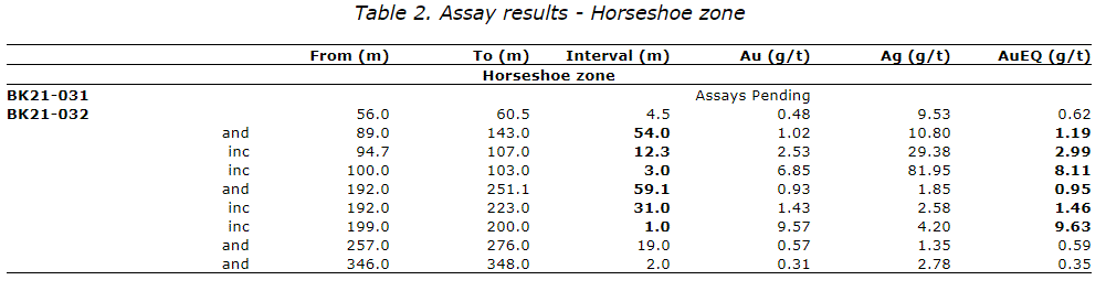
- AuEQ (gold equivalent) based on a 65:1 silver to gold (Ag:Au) ratio.
- Calculations are uncut and length-weighted using a 0.15 g/t gold cutoff with less than five continuous metres of internal dilution.
- Intervals are downhole core lengths. True widths are unknown.
BK21-032 was collared 100 metres northwest of BK21-017 and drilled to the east at a similar dip. The hole returned two significant intervals: an upper interval of 1.19 g/t AuEQ over 54.0 metres from 89.0 to 143.0 metres hosted in sphalerite-rich sulfide-cemented breccias (Figure 1); and a lower interval of 0.95 g/t AuEQ over 59.1 metres including 31.0 metres of 1.46 g/t AuEQ hosted in polymictic breccias with clots of sphalerite + pyrite. The upper interval also contained 1.17% zinc over the 54.0 metres. Hole BK21-032 builds on results from 2020 (e.g., BK20-006, 007, 009 and top of 012) and the recently reported BK21-017 and BK21-018 and expands the zone of sphalerite-rich sulfide-cemented breccias laterally at depth (Figure 3). Assays are pending from one remaining hole in the Horseshoe zone.

Figure 2. Map showing drill hole locations.
To view an enhanced version of Figure 2, please visit:
https://orders.newsfilecorp.com/files/6142/87124_c0622daa6498cb72_002full.jpg

Figure 3. A-A’ Cross section from the Trench to Horseshoe zones showing selected highlights.
To view an enhanced version of Figure 3, please visit:
https://orders.newsfilecorp.com/files/6142/87124_c0622daa6498cb72_003full.jpg
Table 3. Drill collar locations
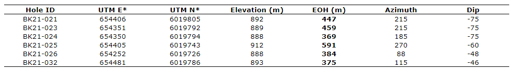
Notes: * NAD 83 Zone 9N
Quality Assurance and Quality Control
All sample assay results have been monitored through the Company’s quality assurance and quality control (QA/QC) program. Drill core was sawn in half at Sun Summit’s core logging and processing facility in Houston, B.C. Half the core was sampled and shipped in sealed and secure bags to the ALS Global preparation facilities in Yellowknife, N.T. Samples were prepared using standard preparation procedures. Following sample preparation, the pulps were sent to the ALS Global analytical laboratory in North Vancouver, B.C., for analysis.
Core samples were analyzed for 48 elements by ICP-MS on a 0.25 gram sample using a four acid digestion (method ME-MS61L or ME-MS61). Gold was analyzed by fire assay on a 30 gram sample with an AAS finish (method Au-AA23). Over limit gold (>10 ppm) was re-analyzed by fire assay using a gravimetric finish on a 30 gram sample. Over limit silver (>100 ppm) was re-analyzed using a four acid digestion and ICP-AES finish. Over limit zinc (> 10,000 ppm) was re-analysed using a four acid digestion and ICP-AES finish. ALS Global is registered to ISO / IEC 17025:2017 accreditations for laboratory procedures.
In addition to ALS Global laboratory QA/QC protocols, Sun Summit implements an internal QA/QC program that includes the insertion of duplicates, standards and blanks into the sample stream.
National Instrument 43-101 Disclosure
This news release has been approved by Sun Summit’s CEO, Robert D. Willis, P. Eng. a “Qualified Person” as defined in National Instrument 43-101, Standards of Disclosure for Mineral Projects of the Canadian Securities Administrators. He has also verified the data disclosed, including sampling, analytical and test data, underlying the technical information in this news release.
Community Engagement
Sun Summit is working to engage with First Nations on whose territory the Buck Property is located, to discuss their interests and identify contract and work opportunities, as well as opportunities to support community initiatives. The Company looks forward to continuing to work with local and regional First Nations as the project continues.
Health and Safety
The Company’s exploration programs are being carried out in full compliance with federal, provincial, and municipal guidelines established in response to the global COVID-19 pandemic. Sun Summit has a rigorous infection prevention and control protocol in place to protect the health of employees and contractors, as well as surrounding communities in which the Company works.
Buck Property
The recently expanded 33,000-hectare property, approximately 12 kilometres south of Houston, British Columbia, has excellent nearby infrastructure and allows for year-round road-accessible exploration.
About Sun Summit
Sun Summit Minerals is an exploration company focused on expanding its epithermal gold discovery at its flagship Buck Project located in north-central British Columbia.
The Company is exploring multiple high priority gold and silver targets through methodical, well-funded exploration campaigns with year round drilling access. The Project has high-grade and bulk-tonnage gold and silver potential and is located in a mining-established region that includes many former operating mines and current exploration projects.
Sun Summit is committed to environmental and social responsibility with a focus on responsible development to generate positive outcomes for all stakeholders.
Further details are available at www.sunsummitminerals.com
Figures
Figure 1
https://sunsummitminerals.com/wp-content/uploads/2021/06/Buck_Fig1_BK21-032_Photo.jpg
Figure 2
https://sunsummitminerals.com/wp-content/uploads/2021/06/Buck_Fig1_Drilling_June10_NR-scaled.jpg
Figure 3
https://sunsummitminerals.com/wp-content/uploads/2021/06/Buck_Fig2_EW_Section_June10_NR-scaled.jpg
For further information, contact:
Sharyn Alexander, M.Sc.
VP Technical Services
Nancy Curry
Corporate Communications
Tel. 778-588-9606
- Published in Mining, News Home, San Marco Resources
Canada Silver Cobalt Files NI 43-101 Technical Report Update for Castle East
Canada Silver Cobalt Works Inc. (TSXV: CCW) (OTC: CCWOF) (Frankfurt: 4T9B) (the “Company” or “Canada Silver Cobalt”) is pleased to report that it has filed a technical report update on SEDAR. The technical report update was prepared in accordance with National Instrument 43-101 Standards of Disclosure for Mineral Projects (“NI 43-101”).
The Castle East property is 100% owned by Canada Silver Cobalt Works. After the last mineral resource estimate (press release of May 28, 2020) the Company initiated an intense surface drilling program at Castle East zone from May 2020 through to April 30, 2021 totaling at 29,966.53m. A mineral resource update should follow once the drilling campaign is completed with all assays received and interpreted. The current mineral resource estimate (press release of May 28, 2020) is still valid.
Qualified Person
The technical information in this news release was prepared under the supervision of Mr. Merouane Rachidi, Ph.D., P.Geo., (PGO, OGQ and AIPG) of GoldMinds Geoservices, an independent qualified person in accordance with National Instrument 43-101.
About Canada Silver Cobalt Works Inc.
Canada Silver Cobalt Works released the first-ever resource in the Gowganda Camp and greater Cobalt Camp in May 2020. A total of 7.56 million ounces of silver in Inferred resources comprising very high-grade silver (8,582 grams per tonne un-cut or 250.2 oz/ton) in 27,400 tonnes of material from two sections (1A and 1B) of the Robinson Zone beginning at a vertical depth of approximately 400 meters were identified. The discovery remains open in all directions (1A and 1B are approximately 800 meters from the Capitol Mine workings) (mineral resources that are not mineral reserves do not have demonstrated economic viability) (refer to Canada Silver Cobalt Works Press Release May 28, 2020. Report reference: Rachidi, M. 2020, NI 43-101 Technical Report Mineral Resource Estimate for Castle East, Robinson Zone, Ontario, Canada, with an effective date of May 28, 2020 and a signature date of July 13, 2020).
Canada Silver Cobalt’s flagship Castle mine and 78 sq. km Castle Property features strong exploration upside for silver, cobalt, nickel, gold and copper in the prolific past producing Gowganda high-grade Silver District of Northern Ontario. With underground access at Castle, a pilot plant to produce cobalt-rich gravity concentrates on site, a processing facility (TTL Laboratories) in the town of Cobalt, and a proprietary hydrometallurgical process known as Re-2OX for the creation of technical grade cobalt sulphate as well as nickel-manganese-cobalt (NMC) formulations, Canada Silver Cobalt is strategically positioned to become a Canadian leader in the silver-cobalt space.
“Frank J. Basa”
Frank J. Basa, P. Eng.
Chief Executive Officer
Neither the TSX Venture Exchange nor its Regulation Service Provider (as that term is defined in the policies of the TSX Venture Exchange) accepts responsibility for the adequacy or accuracy of this release. This news release may contain forward-looking statements including but not limited to comments regarding the timing and content of upcoming work programs, geological interpretations, receipt of property titles, potential mineral recovery processes, etc. Forward-looking statements address future events and conditions and therefore, involve inherent risks and uncertainties. Actual results may differ materially from those currently anticipated in such statements.
SOURCE Canada Silver Cobalt Works Inc.


View original content: http://www.newswire.ca/en/releases/archive/June2021/09/c8459.html
- Published in Canada Cobalt Works, Mining, News Home
Medicine Springs JV – Project Expansion and Exploration Update
Northern Lights Resources Corp. (“Northern Lights” or the “Company”) (CSE:NLR)(OTCQB:NLRCF) is pleased to announce a significant expansion to the claim base and the commencement of exploration work at the Medicine Springs Project located in Elko County, Nevada, that the Company is exploring in joint venture with Reyna Silver Corp. (“Reyna Silver”), (TSX.V:RSVL).
Under the terms of the Medicine Springs Option and Joint Venture Agreement, announced October 5, 2021, Reyna Silver will earn a 75% interest in the Medicine Springs Project (“Medicine Springs” or the “JV Project”) by fulfilling various commitments including completing exploration work commitments totalling US$2.4 million. Reyna may acquire an additional 5% in Medicine Springs by paying Northern Lights US$1.0 million. Under the terms of the Joint Venture, Reyna Silver is responsible for the first US$4.0 million of exploration expenditures, then both Reyna Silver and Northern Lights will contribute to expenditures on a pro-rata equity basis.
In early May, Reyna Silver CEO Jorge Ramiro Monroy, Dr. Peter Megaw and NLR geologist, Dr. Bill Tafuri spent several days at the Medicine Springs site finalizing the 2021 exploration plan for the project. Please see the the link to a presentation by Dr Peter Megaw while on site at Medicine Springs (“Peter Megaw – Medicine Springs“).
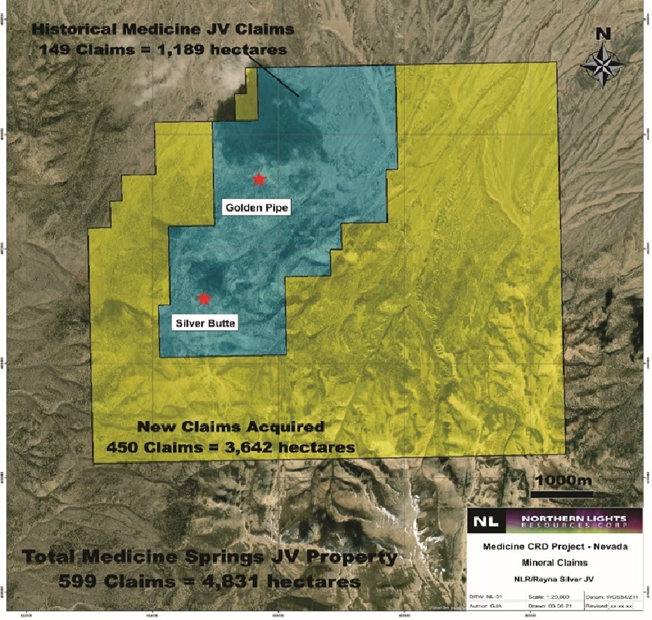
To capture the total limits of the recognized mineralization and alteration system observed at Medicine Springs, Reyna Silver has aggressively staked additional mineral claims contiguous with the original Medicine Springs 1,189 hectare (149 claims) project claim boundaries. A total of 450 new unpatented Federal mineral claims have been added to the JV Project area increasing the total land position to 4,831 hectares (599 claims), an increase of over 300%. (Under the terms of the joint venture with Reyna Silver, any land acquired within a 5-mile radius of the original Medicine Springs mineral claims is included within the JV Project area.) See Figure 1 – Medicine Springs Joint Venture Mineral Claims.
The 2021 exploration plan for the JV Project includes:
- The orientation sampling phase is complete (assays pending)
- A property wide Lidar-like survey is being flown this week. This will facilitate mapping and identify target areas for sampling.
- A systematic property-wide mapping and selective jasperoid sampling program to determine the limits of the alteration system and where its center (or centers) are located.
- Potential additional Magnetic and NSAMT geophysics for drill targeting.
The exploration program builds on geological studies completed by Northern Lights and indicates that there are several mineralization centers in the district developed along strong NE-SW structures reflected by topography and marked by Carbonate Replacement Deposit (“CRD”) style jasperoid alteration. Reyna interprets the known mineralization and alteration as “leakage” from more concentrated mineralization at depth and intends to trace the system to depth by outlining and following the system’s structural “plumbing” network.
“Jasperoids are an important alteration style marking the limits of major CRD systems, so finding them well outside of our initial Medicine Springs property package means the system is larger than we thought and triggered tripling our property holdings–we are comfortable we now cover the whole thing”, stated Dr. Peter Megaw, Technical Advisor to Reyna Silver. “We look forward to defining drill targets quickly by building on Northern Lights excellent work through our expanded district-scale mapping and sampling approach”.
Northern Lights CEO, Jason Bahnsen, commented “We are delighted to work with the excellent team at Reyna Silver to build on the 2+ years of exploration work completed by Northern Lights which led to the identification of CRD mineralization on the project. The recent staking has inceased the project size by over 300%, creating a district scale project with significant potential.”

Figure 1 – Medicine Springs Joint Venture Mineral Claims(For enhanced image click here)
The scientific and technical data contained in this news release was reviewed and approved by Gary Artmont (Fellow Member AUSIMM #312718), Head of Geology and qualified person to Northern Lights Resources, who is responsible for ensuring that the geologic information provided in this news release is accurate and who acts as a “qualified person” under National Instrument 43-101 Standards of Disclosure for Mineral Projects.
For further information, please contact:
Albert Timcke, Executive Chairman and President
Email: rtimcke@northernlightsresources.com
Tel: +1 604 608 6163
Jason Bahnsen, Chief Executive Officer
Email: Jason@northernlightsresources.com
Tel: +1 604 608 6163
Shawn Balaghi, Investor Relations
Email: shawn@northernlightsresources.com
Tel: +1 604 773 0242
About Northern Lights Resources Corp.
Northern Lights Resources Corp is a growth-oriented exploration and development company that is advancing two projects: The 100% owned, Secret Pass Gold Project located in Arizona; and the Medicine Springs silver-zinc-lead Project located in Elko County Nevada where Northern Lights are in joint venture with Reyna Silver Corp (TSX.V “RSLV”), (25% Northern Lights / 75% Reyna Silver).
Northern Lights Resources trades under the ticker of “NLR” on the CSE exchange and “NLRCF” on the OTCQB exchange. This and other Northern Lights Resources news releases can be viewed at www.sedar.com and www.northernlightsresources.com.
About Reyna Silver
Reyna Silver Corp. is a silver exploration company with a robust portfolio of silver assets in Mexico and the US. The Company was built around the Guigui and Batopilas Projects, which formed part of MAG Silver’s original IPO portfolio. It is also actively exploring the Medicine Springs project in Nevada, another CRD target and the La Reyna Project in Chihuahua, an epithermal vein project in the historic Cusihuriachic district. Reyna’s strategy centers around leveraging its expertise in Mexico and elsewhere to explore projects that have the potential for high-grade, district-scale discoveries.
- Published in Mining, News Home, Northern Lights Resources
TRU Precious Metals Doubles Phase One Drill Program to up to 2,500 Meters at its 100% Owned Twilite Gold Project
TRU Precious Metals Corp. (TSXV: TRU) (OTCQB: TRUIF) (FSE:706) (“TRU” or the “Company”) is pleased to announce that the Company is expanding the current phase 1 drill program at its 100% owned Twilite Gold Project (“Twilite Gold”) in the Central Newfoundland Gold Belt to up to approximately 2,500 meters, further to its previous announcement on June 1, 2021.
The drill target was previously identified by TRU during a detailed ground geophysical survey in November of 2020, as announced on December 8, 2020. Twilite Gold is strategically located on the mapped extension of the Cape Ray-Valentine Lake Shear Zone. Numerous advanced-stage gold exploration projects are currently underway along this district-scale shear zone, including Marathon Gold’s multi-million-ounce deposit at Valentine Lake, and Matador Mining’s Cape Ray deposit.
Barry Greene, VP of Property Development and Director of TRU, commented: “After reviewing the core from TL21-16, our first drill hole of 2021, I am excited to expand the Twilite Gold drill program. Most of the drilling will be focused on exploring and expanding the mineralized structure associated with a magnetic low, beginning with close undercuts of historical holes first and followed closely with about 25m to 50m step-outs along the structure. There is no shortage of room to move both horizontally and vertically along the structure, enabling us to easily expand the drill program.”
The drill program will consist of approximately 10-15 NQ boreholes situated along a deep seated, multi kilometer, west-northwest trending mineralized structure (Figure 1). The drilling will focus on an approximately 500m strike length section of this structure near the intersection with a northeast trending mineralized structure that is also auriferous in historic drilling. The target mineralized structure appears as a prominent and deep-seated feature on geophysical 3D modeling images and will be drill tested to a maximum depth of approximately 350 m below surface.
Barry Greene, VP of Property Development and Director of TRU, continued: “Meantime, we are pleased to see that diamond drill hole TL21-16 has intersected quartz veined intervals including a distinct and more intense interval of approximately 9m from 126m to 135m at or near the contact between strongly bleached and altered mafic volcanics and a sheared graphitic unit containing veined and brecciated quartz with stringer and clotty pyrite. TL21-16 was an undercut of historic drill hole TL99-14. Unlike hole TL99-14 which had poor core recovery, hole TL21-16 has much better recoveries through the mineralized zone.”
After initial drill core observations are made, the core is transported to TRU’s secure core logging facility where the core is being logged, marked for sampling and then split using a core saw. The samples will be shipped to Eastern Analytical assay lab in Springdale, Newfoundland for gold fire assay.
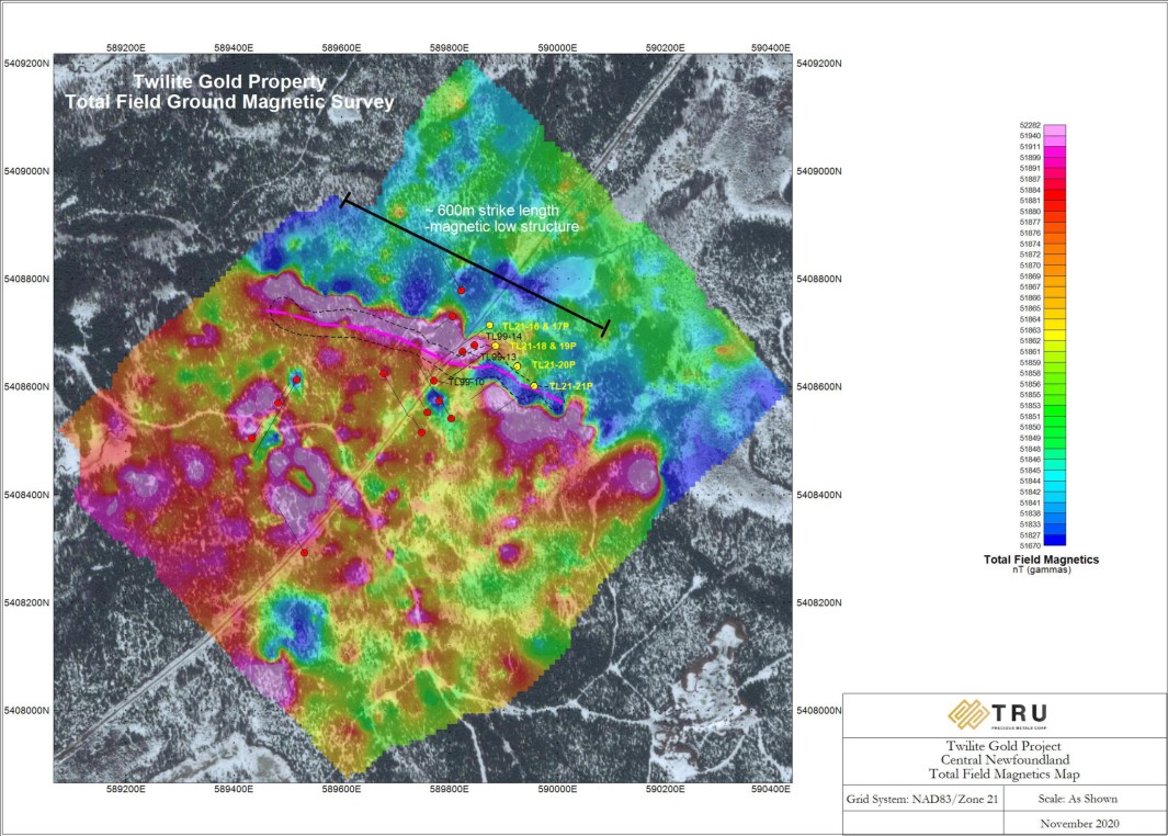
Figure 1: Twilite Gold Proposed Drilling Plan View
To view an enhanced version of Figure 1, please visit:
https://orders.newsfilecorp.com/files/5993/86828_50807bf3043fab65_001full.jpg
TRU Co-Founder and CEO Joel Freudman added: “Exploration, particularly this drill program at Twilite, is one of TRU’s two key value drivers, the other being M&A at the property and corporate levels. Therefore, given that we are already permitted for a more extensive drill program, we think it prudent to expand the program’s scope by adding several holes to better test the structure. We look forward to unearthing the potential value at Twilite Gold.”
As previously disclosed on December 8, 2020, the Company combined the results of a high-resolution, detailed ground magnetic survey around known historical gold occurrences at Twilite Gold with other historical data to develop the drill target currently being tested. The structurally controlled gold mineralization near the Spring Pit showing within Twilite Gold correlates directly with a prominent magnetic low that continues to depth (Figure 2). The modeling also indicates that the magnetic low associated with the mineralized structure continues in a northwesterly direction for at least 600 metres (m) to the limit of the current magnetic survey.
The mineralized structure was intersected by three shallow diamond drill holes in a 1999 drilling program by Fort Knox Gold Resources, and all such holes contained gold mineralization. Notably, drill hole TH-99-10 intersected 8.41m @ 3.28 grams per tonne (g/t) gold (Au) at the top of the structure. The deepest hole to date on this structure intersected 13.3m @ 1.02 g/t Au.

Figure 2: Twilite Gold Cross-Section
To view an enhanced version of Figure 2, please visit:
https://orders.newsfilecorp.com/files/5993/86828_50807bf3043fab65_002full.jpg
TRU has not verified the historical assay results contained in this press release and is not relying on them as current mineral resources or mineral reserves. Note that drill hole results are select samples and are not necessarily representative of mineralization on Twilite Gold. The diagrams and technical information herein relating to Twilite have been supplied by the vendor and have not been independently verified by the Company. Readers are cautioned that these potential grades are conceptual in nature; there has been insufficient exploration by the Company or its qualified person at Twilite Gold to define a mineral resource or mineral reserve; and it is uncertain whether further exploration will result in these targets being delineated as a mineral resource or mineral reserve.
Finally, the Company’s chief executive officer has issued a letter to shareholders. A copy of the letter is available to all interested readers on the Company’s website.
Barry Greene, P.Geo. (NL) is a qualified person as defined by National Instrument 43-101 and has reviewed and approved the contents and technical disclosures in this press release. Mr. Greene is a director and officer of the Company and owns securities of the Company.
About TRU Precious Metals Corp.
TRU has assembled a portfolio of 5 gold exploration properties in the highly prospective Central Newfoundland Gold Belt. The Company has an option with a subsidiary of TSX-listed Altius Minerals Corporation to purchase 100% of the Golden Rose Project, located along the deposit-bearing Cape Ray – Valentine Lake Shear Zone. TRU also owns 100% of the Twilite Gold Project, located along the same Shear Zone, and 3 under-explored properties including its Rolling Pond Property (under option) bordering New Found Gold Corp.’s high-grade Queensway Project. TRU’s common shares trade on the TSX Venture Exchange under the symbol “TRU”, on the OTCQB Venture Market under the symbol “TRUIF”, and on the Frankfurt exchange under the symbol “706”.
TRU is a portfolio company of Resurgent Capital Corp. (“Resurgent”), a merchant bank providing venture capital markets advisory services and proprietary financing. Resurgent works with promising public and pre-public micro-capitalization Canadian companies. For more information on Resurgent and its portfolio companies, please visit Resurgent’s LinkedIn profile at https://ca.linkedin.com/company/resurgent-capital-corp.
For further information about TRU, please contact:
Joel Freudman
Co-Founder, President & CEO
TRU Precious Metals Corp.
Phone: 1-855-760-2TRU (2878)
Email: info@trupreciousmetals.com
Website: www.trupreciousmetals.com
To connect with TRU via social media, below are links:
Facebook
https://www.facebook.com/TRU-Precious-Metals-Corp-100919195193616
Twitter
https://twitter.com/corp_tru
LinkedIn
https://www.linkedin.com/company/tru-precious-metals-corp
YouTube
https://www.youtube.com/channel/UCHghHMDQaYgS1rDHiZIeLUg/
- Published in Mining, News Home, Tru Precious Metals
Northern Lights Receives Permit to Drill Tin Cup Prospect at Secret Pass
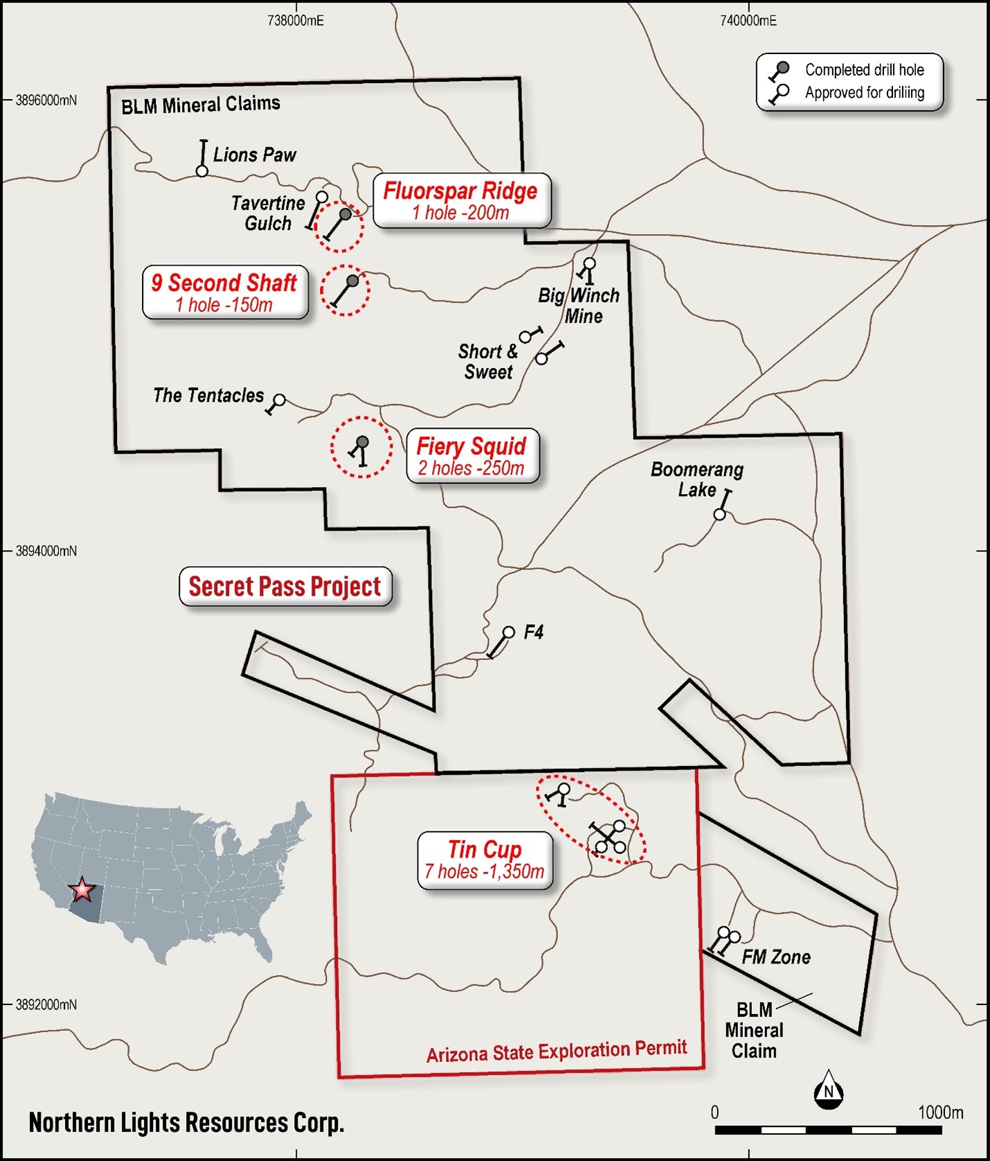
Northern Lights Resources Corp. (“Northern Lights” or the “Company”) (CSE:NLR)(OTCQB:NLRCF) is pleased to announce that it has received approval from the Arizona State Land Department ( the “ASLD”) to commence drilling at the Tin Cup Prospect at the Company’s Secret Pass Gold Project (“Secret Pass”) in Mohave County, Arizona.
Northern Lights began drilling at Secret Pass on April 15 and is now completing the 4rth drill hole (total approximately 600 metres) out of the total 22 permitted drill holes located on mineral claims registered with the US Bureau of Land Management (the “BLM”). The prospects drilled included Fiery Squid, Nine Second Shaft and Fluorspar Ridge locations. (See Figure 1) All drill core has been split and sent to Skyline Laboratories in Tucson, assays are pending.
CEO, Jason Bahnsen, commented “Historic RC drilling at Tin Cup in the 1980s intersected steeply angled veins with grades up to 40 grams per tonne gold. We are excited to begin drilling at Tin Cup where we plan to confirm the previous high-grade RC results with large diameter HQ diamond core drilling and test the system to a depth of approximately 350 metres, well below the maximum historic drilling depth of 180 metres. We are completing drilling at the Fluorspar Ridge Prospect and will immediately move the drill to the Tin Cup Prospect to begin the planned 7-hole program.”
Seven exploration drill holes have been approved at the Tin Cup Prospect (total 1,350 metres planned) The initial drill program at Tin Cup is planned to confirm high-grade mineralization from historic drilling and to test the down plunge extension of the mineralization to a depth of approximately 350 metres below the surface.
Table 1 – Planned Drill Holes at Tin Cup Prospect
| Hole No. | Location | Azimuth (o) | Dip (o) | Length (m) |
| TC01 | Tin Cup | 310 | -50 | 250 |
| TC02 | Tin Cup | 220 | -45 | 175 |
| TC03 | Tin Cup | 220 | -55 | 225 |
| TC04 | Tin Cup | 220 | -65 | 400 |
| TC05 | Tin Cup | 040 | -60 | 100 |
| TC06 – F2 | Tin Cup | 180 | -45 | 100 |
| TC07 – F2 | Tin Cup | 100 | ||
| Total | 1,350 |
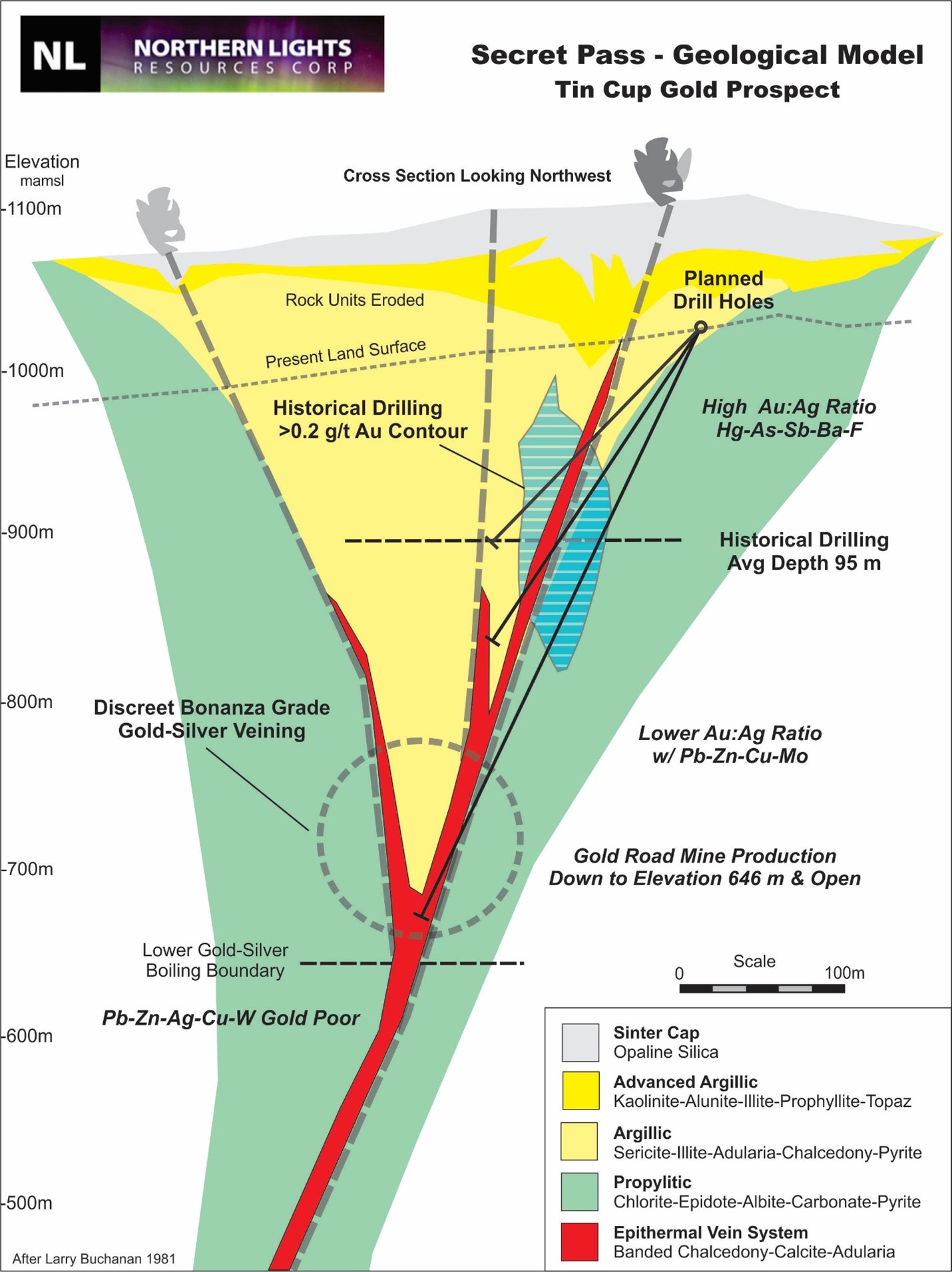
Tin Cup Zone
Records show that there was an historic small scale open pit and underground mine located at Tin Cup. The mine reportedly produced several hundred tons of mineralized materialgrading 15 g/t to 31 g/t of gold. Historic workings, from approximately 1918 to the early 1930’s, included an open pit and an inclined shaft to a depth of 21 metres (70 ft) with minorunderground level workings.
During the period from 1984 to 1991, a total of 145 drill holes (predominately reverse circulation drilling) were drilled at Tin Cup with a number of holes intersecting high grade gold mineralization. The historic drilling had an average depth of approximately 95 metres and a maximum depth of 180 metres.
The Tin Cup Gold Zone is localized along the steeply northeast-dipping Frisco Mine
Fault. The gold mineralization is hosted by Tertiary andesite and associated with the
margins of rhyolite dykes that occur as lenses within the Frisco Mine Fault. A few of the
deepest historic drill holes intersect gold mineralization in the Proterozoic basement granite.
The mineralized zone at Tin Cup has a strike length of approximately 245 metres to drill-indicated depth of 180 metres and is open along strike and depth. Higher grademineralization (greater than 10 g/t Au), is localized in narrow sub-vertical structures developed within broader zones of lower grade mineralization ranging up to 86 metres in width. The mineralization plunges to the northwest at 50 degrees. Surface oxidation is variable extending to a maximum depth of up to120 metres based on historical drilling. Selected historic intersections are summarized in Table 2.
Table 2 – Selected Historic Drill Results at Tin Cup Zone
| Hole No. | Year | Type | Depth (m) | Interval (m) | Width (m) | Au g/t |
| TC-01 | 1984 | RC | 52 | 22.9-30.5 | 7.6 | 7.6 |
| 21.2-51.5 | 30.3 | 2.9 | ||||
| TC-10 | 1985 | RC | 176 | 89.9-121.9 | 32 | 13.6 |
| including | 1.5 | 40.4 | ||||
| including | 12.2 | 20.8 | ||||
| TC-15 | 1985 | RC | 146 | 111.2-115.8 | 4.6 | 13.1 |
| TC-30 | 1986 | RC | 150 | 63.3-150 | 86.7 | 4.1 |
| including | 9.1 | 17.7 | ||||
| TC-32 | 1986 | RC | 90 | 18.8-69.7 | 50.9 | 2.7 |
| TC-11 | 1987 | RC | 90.9 | 46.9-90.9 | 44 | 2.8 |
| TC-14 | 1986 | RC | 121 | 90.9-121.9 | 31 | 5.8 |
Note: These results are historical in nature and a Qualified Person has not done sufficient work to verify these previous drilling results. Previously released on October 28, 2020.
Figure 1 -Secret Pass Project Drill Hole Locations
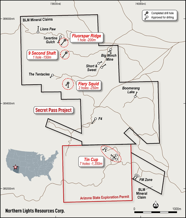
Figure 2 – Tin Cup Prospect Cross-Section Model

The scientific and technical data contained in this news release was reviewed and approved by Gary Artmont (Fellow Member AUSIMM #312718), Head of Geology and qualified person to Northern Lights Resources, who is responsible for ensuring that the geologic information provided in this news release is accurate and who acts as a “qualified person” under National Instrument 43-101 Standards of Disclosure for Mineral Projects.
For further information, please contact:
Albert Timcke, Executive Chairman and President
Email: rtimcke@northernlightsresources.com
Tel: +1 604 608 6163
Jason Bahnsen, Chief Executive Officer
Email: Jason@northernlightsresources.com
Tel: +1 604 608 6163
Shawn Balaghi, Investor Relations
Email: shawn@northernlightsresources.com
Tel: +1 604 773 0242
About Northern Lights Resources Corp.
Northern Lights Resources Corp is a growth-oriented exploration and development company that is advancing two projects: The 100% owned, Secret Pass Gold Project located in Arizona; and the Medicine Springs silver-zinc-lead Project located in Elko County Nevada where Northern Lights, in joint venture with Reyna Silver are earning 100% ownership. Northern Lights Resources is a member of the Arizona Mining Association.
Northern Lights Resources trades under the ticker of “NLR” on the CSE. This and other Northern Lights Resources news releases can be viewed at www.sedar.com and www.northernlightsresources.com.
- Published in News Home, Northern Lights Resources
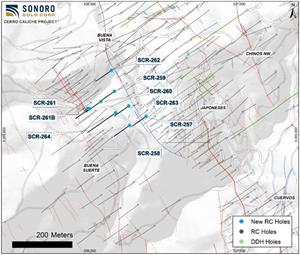
Sonoro Gold Completes Phase 3 Drill Program and Moves Towards an Updated N1 43-101 Technical Report and New PEA for Cerro Caliche
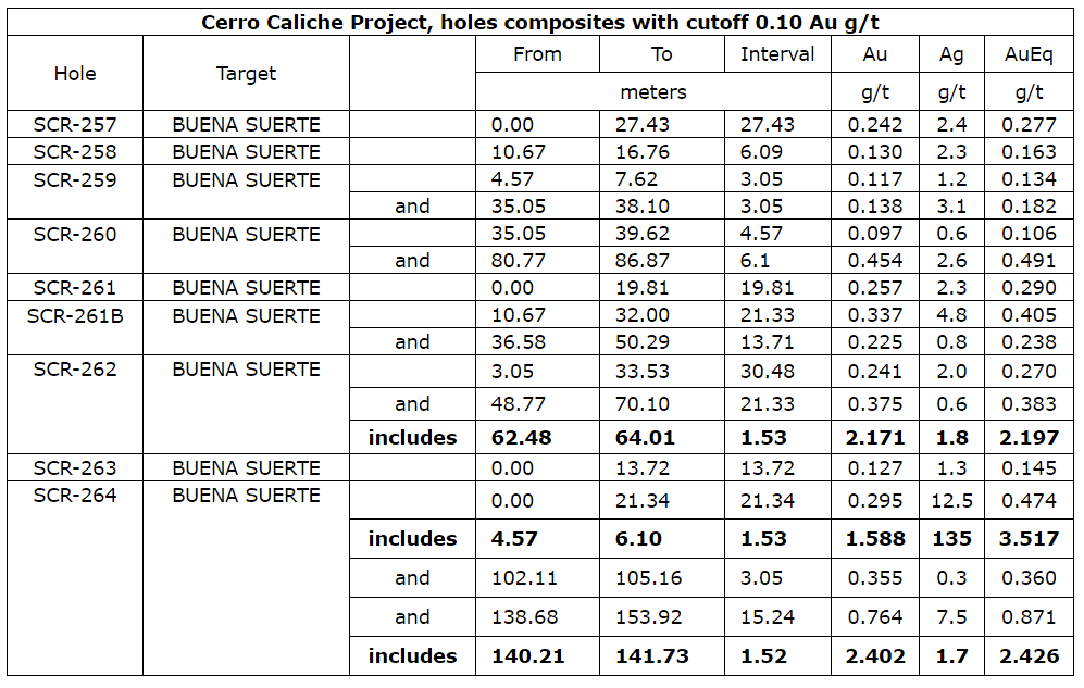
Sonoro Gold Corp. (TSXV: SGO | OTCQB: SMOFF | FRA: 23SP) (“Sonoro” or the “Company”) is pleased to report assay results from the final nine RC drill holes, completing Phase Three of its drilling program at the Cerro Caliche gold project, located in Sonora State, Mexico. As noted in news releases, dated April 5, 2021, and April 26, 2021, the Company extended drilling activities to investigate the potential merging of the Japoneses and Buena Suerte zones into a single body of shallow, oxide gold mineralization. Recent results indicate a coalescence of the two zones over a minimum length of 400 meters which may prove to have significant and positive economic implications for the Company’s proposed Heap Leach Mining Operation (HLMO).
The following map shows the location of the nine RC drill holes as well as the merging of the northern extents of the Japoneses and Buena Suerte zones.
A photo accompanying this announcement is available at https://www.globenewswire.com/NewsRoom/AttachmentNg/809af3db-65f4-4881-92a1-be91dc3086ab
Two independent NI 43-101 technical reports, scheduled to be filed in July 2021, will provide valuable information as to whether the identified mineralization is sufficient to support a proposed HLMO with an initial operating capacity of up to 15,000 tons per day (tpd). As previously announced, the Company engaged D.E.N.M. Engineering Ltd. to prepare a Preliminary Economic Assessment (PEA) and Micon International Ltd. to prepare a mineral resource estimate. The mineral resource estimate will include all prior and current exploration data up to April 2021. To date, the Company has drilled and assayed results from over 34,500 meters of drilling, including over 25,000 meters of new drilling since September 2020. When combined with historical data, total exploration at Cerro Caliche totals over 47,500 meters, 433 drill holes and 9,365 surface samples.
Drilling activities on the concession are currently paused to provide the exploration team time to ensure all data and assistance is available to the independent consultants, and to implement any recommendations set forth in the anticipated technical reports. Subject to the terms of project financing, drilling is scheduled to resume by the end of the third quarter of 2021 to continue expanding mineralization and investigating potential high-grade targets.
Potential Coalescence of Japoneses and Buena Suerte Gold Zones
The final nine drill holes were completed along the narrowing gap between the northwest extension of the Japoneses zone, known as the Buena Vista fault vein zone, and the east flank of the Buena Suerte zone. Four of the drill holes cut the east side of Buena Suerte with drill hole SCR-264 intercepting 15.24 meters averaging 0.764 grams of gold per tonne (“g/t Au”), including 1.52 meters averaging 2.402 g/t Au. Drill hole SCR-261 encountered continuous mineralization from surface but intercepted an artisanal mine working at 19.81 meters. The rig was moved 6 meters and the hole was re-drilled as SCR-261B, which intercepted a total of 35 meters of gold mineralization, including 1.5 meters averaging 1.23 g/t Au.
In the northern extent, roughly at the center of the 150-meter gap separating Japoneses and Buena Suerte, drill hole SCR-262 cut multiple intervals of gold mineralization totaling 52 meters from surface including 1.53 meters averaging 2.171 g/t Au. While this area was previously considered to be outside of the mineralized gold zones, drilling results confirm the material presence of gold mineralization and further support the development of a single pit to mine gold mineralization from both the Japoneses and Buena Suerte zones.
These final drilling results mark the conclusion of a highly successful and intense drilling program. As noted above, management expects two independent 43-101 compliant reports to update the resource size and classification and determine whether it is sufficient to support the Company’s proposed HLMO with a conceptual operation of up to 15,000 tpd.
Mel Herdrick, Sonoro’s VP of Exploration noted, “I am pleased that these latest drill holes show the area between the two gold bearing zones, which was previously considered barren, does in fact carry gold mineralization. It is a very encouraging ending for what has been a very effective drill program. There remains much more potential in the areas we plan to drill later this year and next and I expect that this drilling will continue to define and materially expand and categorize the project’s oxide gold mineralization.”
Kenneth MacLeod, Sonoro’s President and CEO added, “We have reached a watershed juncture in the development of Sonoro, as we are now making the transition from an exploration company to our aspirational goal of becoming a gold producer in early 2022. We are grateful for the support of our shareholders over the past three years as we strive to make Cerro Caliche the next mining success story in Mexico.”
John Darch Sonoro’s Chairman commented, “These final drill results reinforce the potential for the Japoneses-Buena Vista and Buena Suerte zones to be assessed as a single pit with all of the attendant cost savings that a single pit may make possible. They also mark the conclusion of an exceptional year, where Sonoro has been transformed from an exploration junior to a development stage company with a goal of achieving production early next year. Our strategy of exploring and developing Cerro Caliche’s extensive shallow oxide gold mineralization while advancing towards becoming a gold producer is advancing as we had hoped. We anticipate this will be confirmed with the filing of the Micon International’s 43-101 technical report on an updated resource estimate, as well as with the filling of the anticipated PEA regarding the proposed project’s economics.”
Assay Results
Drill collar locations, azimuths and dips for the drill holes included are provided in the table below.
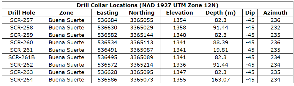
All reported intervals in this news report are 45-degree inclined drill holes cutting an assumed 60–90-degree dipping vein zone toward the drill hole, thus the intercept is considered to be approximately 20 degrees or less from having a perpendicular intersection. The true widths of reported drill widths are anticipated to be about 75 percent or more of intercept widths reported.
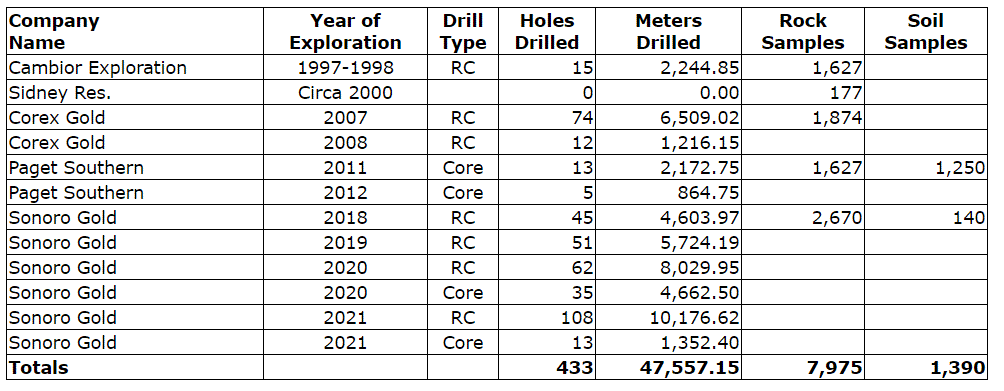
The above table illustrates the exploration history of the Cerro Caliche concession. Sonoro commenced drilling in October 2018 and completed the first two phases by June 2019 for a total of 96 drill holes totaling 10,328 meters. The Company initiated Phase 3 drilling in August 2020 and completed the program in April 2021. During Phase three, Sonoro completed 170 RC drill holes (18,206.57 meters) and 48 diamond drill core holes including 11 metallurgical PQ drill holes (6,014.9 meters) for a Phase 3 total of 24,221.47 meters of drilling. Total Sonoro drilling amounts to 34,549.63 meters in 314 drill holes. The earlier Corex and Paget drilling of 104 drill holes over 10,762.67 meters, brings the drilling database to a total of 45,312.3 meters over 418 drill holes. Additionally, the data from earlier drilling by Cambior totaling 2,244.85 meters over 15 holes is appended to the Sonoro database.
Quality Assurance/Quality Control (“QA/QC”) Measures and Analytical Procedures
Drill samples are collected with an airstream cyclone and passed into a splitter that divides each sample into quarters. The quartered samples are then bagged and sealed with identification. The sample group has blanks, standards and duplicates inserted into the sample stream.
Bureau Veritas (BV) collects the samples from the drill site and transports them directly to the preparation laboratory in Hermosillo, Sonora. At the preparation laboratory, a split part of each sample (about 500 grams) is reduced through crushing, splitting and pulverization. Thirty grams of each pulverized sample is split apart in the Hermosillo laboratory and undergoes a “Fire Assay” for gold content by reducing the fire assay to a concentrated button of material that is dissolved in acids and the gold content determined by atomic absorption. About another 200 grams of each sample are sent by BV to their Vancouver, Canada laboratory and dissolved in aqua regia for multi-element ICP analysis, including silver.
No QA/QC issues were noted with the results received from the laboratory.
Geologic Description
Cerro Caliche is located 45 kilometers east southeast of Magdalena de Kino in the Cucurpe-Sonora Mega-district of Sonora, Mexico. Multiple historic underground mines were developed in the concession including Cabeza Blanca, Los Cuervos, Japoneses, Las Abejas, Boluditos, El Colorado, Veta de Oro and Espanola. Mineralization types of the Cucurpe-Sonora Mega-district include variants of epithermal low sulfidation veins and related mineralized dikes and associated volcanic domes. Local altered and mineralized felsic dikes cut the mineralized meta-sedimentary rock units and may be associated with mineralization both in the dikes and meta-sedimentary rocks.
Qualified Person Statement
Stephen Kenwood, P.Geo., a Director of Sonoro, is a Qualified Person within the context of National Instrument 43-101 (NI 43-101) and has read and approved this news release. Readers are cautioned that the presence of mineralization on historic mines adjacent to or on Cerro Caliche is not necessarily indicative of economic gold mineralization in the concessions held by the Company.
About Sonoro Gold Corp.
Sonoro Gold Corp. is a publicly listed exploration and development company with a portfolio of exploration-stage precious metal properties in Sonora State, Mexico. The Company has highly experienced operational and management teams with proven track records for the discovery and development of natural resource deposits.
On behalf of the Board of Sonoro Gold Corp.
Per: “Kenneth MacLeod”
Kenneth MacLeod
President & CEO
For further information, please contact:
Sonoro Gold Corp. – Tel: (604) 632-1764
Email: info@sonorogold.com
Forward-Looking Statement Cautions: This press release contains certain “forward-looking statements” within the meaning of Canadian securities legislation, relating to, among other things, the Company’s plans for the exploration, development and operations at the above-described Cerro Caliche Concessions, located in the municipality of Cucurpe, Sonora, Mexico, including statements regarding the Company’s plans for additional exploration drilling, an anticipated update of the current resource estimate for Cerro Caliche to be included in a Micon International 43-101 technical report to be published in Q3 2021, a planned preliminary economic assessment (“PEA”) to be published in 2021 reporting on the viability of a proposed 20,000 tonne/day mining operation, and other material conditions set out above on which the Company’s development plans are dependent. Although the Company believes that such statements are reasonable based on current circumstances, it can give no assurance that such expectations will prove to be correct. Forward-looking statements are statements that are not historical facts; they are generally, but not always, identified by the words “expects”, “plans”, “anticipates”, “believes”, “intends”, “estimates”, “projects”, “aims”, “potential”, “goal”, “objective”, “prospective” and similar expressions, or that events or conditions “will”, “would”, “may”, “can”, “could” or “should” occur, or are those statements, which, by their nature, refer to future events. The Company cautions that forward-looking statements are based on the beliefs, estimates and opinions of the Company’s management on the date the statements are made and they involve a number of risks and uncertainties, including the possibility of unfavourable exploration and test results, unfavourable results of the contemplated PEA of the Cerro Caliche project, the lack of sufficient future financing to carry out exploration and development plans and unanticipated changes in the legal, regulatory and permitting requirements for the Company’s exploration programs. There can be no assurance that such statements will prove to be accurate, as actual results and future events could differ materially from those anticipated in such statements. Accordingly, readers should not place undue reliance on forward-looking statements. The Company disclaims any intention or obligation to update or revise any forward-looking statements, whether as a result of new information, future events or otherwise, except as required by law or the policies of the TSX Venture Exchange. Readers are encouraged to review the Company’s complete public disclosure record on SEDAR at www.sedar.com.
Neither the TSX Venture Exchange nor its Regulation Services Provider (as that term is defined in the policies of the TSX Venture Exchange) accept responsibility for the adequacy or accuracy of this release.
Cerro Caliche Project Drill Holes
- Published in Mining, News Home, Sonoro Gold