Canada Silver Cobalt Intersects 30,416 g/t Silver over 0.42m with 425 g/t Gold Equivalent in New Vein at Castle East
Three impressive new intercepts add two new high-grade vein structures separate from both the Robinson Zone and Big Silver and bring the silver even closer to surface.
Coquitlam, BC – TheNewswire – August 9, 2021 – Canada Silver Cobalt Works Inc. (TSXV:CCW) (OTC:CCWOF) (Frankfurt:4T9B) (the “Company” or “Canada Silver Cobalt”) is pleased to announce a continued expansion at Castle East with three new, high-grade intersections with silver grades of 30,416.91 g/t over 0.42m, 7,328.47 g/t over 0.38m, 1,883.21 g/t Ag over 0.42m, and with gold equivalent grades of 425.94 g/t, 102.62 g/t, 26.37 g/t AuEq respectively.
Drilling Highlights:
- – Hole CS-21-61 with an exceptional intercept grading 30,416.91 g/tonne silver (887.31 oz/ton Ag) over 0.42m at a downhole depth of 449.55-449.97m with a gold equivalent grade of 425.94 g/tonne Au (12.42 oz/ton Au ). This incredibly mineralized vein is located 35m south from the Robinson Zone discovery hole CA-11-08, and 60m west of Big Silver discovery hole CS-20-39. The Company currently believes this intercept belongs to a brand-new vein structure, independent from both the Robinson Zone and the Big Silver vein.
- – The first intercept in hole CS-21-65 contains 7,328.47 g/tonne silver (213.77 oz/ton Ag) over 0.38m at a downhole depth of 254.03-254.41m with a gold equivalent grade of 102.62 g/tonne Au (2.99 oz/ton Au). This intercept is located 230m below the surface, 70m to the south and 220m above the Robinson Zone. To date, this is the closest high-grade intercept to surface and is located within Archean lithologies.- The second intercept in hole CS-21-65 contains 1,883.21 g/tonne silver (54.93 oz/ton Ag) over 0.42m at a downhole depth of 421-421.42m with a gold equivalent grade of 26.37 g/tonne Au (0.77 oz/ton Au).
“These three intercepts provide us with two newly discovered, high-grade vein systems. We continue to have excellent results from the 60,000m drill program at Castle East, with 40,000m completed to date. There is now a total of eight distinct high-grade veins to be included in the Q1 2022 resource update. The initial estimate in May 2020 for Castle East (see below) was based solely on the Robinson Zone vein system but recent drilling has discovered an even higher-grade vein (Big Silver grading 89,853 g/t Ag over 0.30m) in addition to six other new vein structures, and our exploration program has expanded the overall area to be included in the resource estimate.” said Matt Halliday, P.Geo., President, and COO.
The geological implications of these veins are threefold: First, the addition of another exceptionally high-grade vein in CS-21-61 puts us that much closer to significant expansion of the resource at Castle East. Second, the high-grade silver vein in CS-21-65 (that is 230m below the surface) confirms the existence of much shallower silver mineralization at Castle East. Third, it greatly expands the potential for silver mineralization to occur across the entire property because it occurs within the Archean lithologies. Most of our high-grade or notable veins are located within the younger Nipissing Diabase sill which is intruding into the older Archean rocks. This means that it is possible for further silver mineralization to occur in the same Archean lithologies both above and below the Nipissing Diabase, similarly to the vein found in CS-21-65 that is located above the intrusion. As a further proof of concept, both the Beaver Mine and Temiskaming Mine had significant production both above and below the Nipissing diabase intrusion. This ultimately expands the potential horizon within the property and is very encouraging for future exploration.
Table 1 : Sample Details
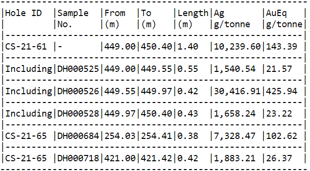
Note: Gold equivalent (AuEq) is calculated based on USD $25.37 oz/ton Ag and USD $1811.72 oz/ton Au as of August 5 th , 2021.
Click Image To View Full Size
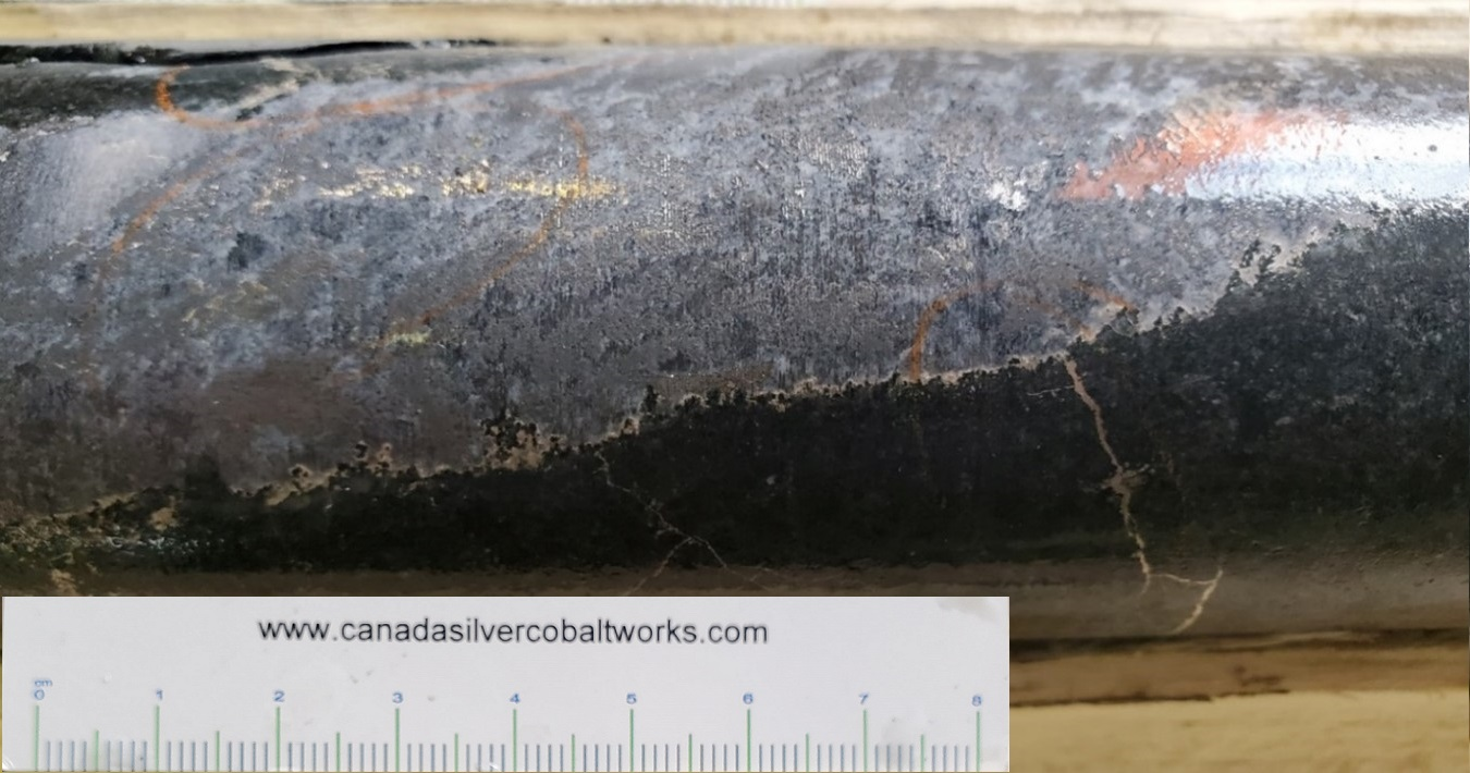
Figure 1: Close-up of mineralization in hole CS-21-61 (30,416.91 g/tonne Ag). One can see the intense Cobalt mineralization occurring as the dark grey minerals within the vein. The bright silver is located within the cobalt clusters as well as lining the edge of the vein and radiating outwards.
Ongoing drilling in the Castle East area is geared toward identifying new veins to enable significant expansion to the existing resource panels outlined in the Company’s maiden Resource Estimate reported in a news release May 28, 2020. The resource estimate identified zones 1A and 1B of the Robinson Zone with an average silver grade of 8,582 g/t ( 250 oz/ton ) in a combined 27,400 tonnes of material for a total of 7.56 million Inferred ounces of silver using a cut-off grade of 258 g/t AgEq (mineral resources that are not mineral reserves do not have demonstrated economic viability). Report reference: Rachidi, M. 2020, NI 43-101 Technical Report Mineral Resource Estimate for Castle East, Robinson Zone, Ontario, Canada , with an effective date of May 28, 2020 and a signature date of July 13, 2020.
Location
The Castle Property is 15 km east of Aris Gold Corp’s Juby gold deposit, 30 km due south of Alamos Gold’s Young-Davidson mine, 75 km southwest of Kirkland Lake Gold’s Macassa Complex, and 100 km southeast of new gold discoveries in the Timmins West area.
Qualified Person
The technical information in this news release was prepared under the supervision of Mr. Matthew Halliday, P.Geo., (APGO) VP Exploration of Canada Silver Cobalt Works Inc., a qualified person in accordance with National Instrument 43-101.
About Canada Silver Cobalt Works Inc.
Canada Silver Cobalt Works Inc. recently discovered a major high-grade silver vein system at Castle East located 1.5 km from its 100%-owned, past-producing Castle Mine near Gowganda in the prolific and world-class silver-cobalt mining district of Northern Ontario. This discovery has the highest silver resource grade in the world, with recent drill intercepts of up to 89,853 grams/tonne silver (2,621 oz/ton Ag). A drill program is underway to expand the size of the deposit with an update to the resource estimate scheduled for Q1 2022.
In May 2020, based on a small initial drill program, the Company published the region’s first 43-101 resource estimate that contained a total of 7.56 million ounces of silver in Inferred resources, comprising very high-grade silver (8,582 grams per tonne un-cut or 250.2 oz/ton) in 27,400 tonnes of material from two sections (1A and 1B) of the Castle East Robinson Zone, beginning at a vertical depth of approximately 400 meters. Note that mineral resources that are not mineral reserves do not have demonstrated economic viability. Please refer to Canada Silver Cobalt Works Press Release May 28, 2020, for the resource estimate. Report reference: Rachidi, M. 2020, NI 43-101 Technical Report Mineral Resource Estimate for Castle East, Robinson Zone, Ontario, Canada, with an effective date of May 28, 2020, and a signature date of July 13, 2020.
Canada Silver Cobalt’s flagship silver-cobalt Castle mine and 78 sq. km Castle Property feature strong exploration upside for silver, cobalt, nickel, gold, and copper. With underground access at the fully owned Castle Mine, an exceptional high-grade silver discovery at Castle East, a pilot plant to produce cobalt-rich gravity concentrates on site, a processing facility (TTL Laboratories) in the town of Cobalt, and a proprietary hydrometallurgical process known as Re-2Ox (for the creation of technical-grade cobalt sulphate as well as nickel-manganese-cobalt (NMC) formulations), Canada Silver Cobalt is strategically positioned to become a Canadian leader in the silver-cobalt space. More information at www.canadasilvercobaltworks.com .
“Frank J. Basa”
Frank J. Basa, P. Eng.
Chief Executive Officer
For further information, Contact:
Frank J. Basa, P.Eng.
Chief Executive Officer
416-625-2342
- Published in Canada Cobalt Works, Mining, News Home
Canada Silver Cobalt Works Acquires Prospective Gold Property Near Kirkland Lake Gold’s Macassa Mine
The acquisition of this highly prospective property places the company in the middle of the most prolific high-grade gold-bearing areas in Northern Ontario that have produced 24 million ounces of gold in the last 100 years.
Coquitlam, BC – TheNewswire – August 3, 2021 – Canada Silver Cobalt Works Inc. (TSXV:CCW) (OTC:CCWOF) (Frankfurt:4T9B) (the “Company” or “Canada Silver Cobalt”) is pleased to announce that it has entered into an Option Agreement dated July 28, 2020 to acquire the Eby-Otto Township property (the “Property”) from geologist Doug Robinson, P.Eng., and prospector James Reed .
Acquisition Highlights:
- – Property lies within the prolific Kirkland Lake district and is located within 5 km of the high-grade Macassa Gold Mine currently operated by Kirkland Lake Gold.- Property contains approximately 200-hectares with a strike length of over 2 km.- Numerous strongly altered and mineralized quartz veins outcropping at surface have been discovered. The mineralization and alteration are highly favorable in addition to being typical of other gold-bearing veins in the district.- Preliminary channel sampling has been recently completed with the assays pending.- Property comes highly recommended by Doug Robinson, a long-time geologist who originally discovered Canada Silver Cobalt’s Robinson Zone, and Jim Reed, an experienced prospector highly familiar with the area.- Acquisition allows the company to expand our precious metals portfolio into the well-established Kirkland Lake Gold camp as well as the prolific Larder Lake-Cadillac Break system.
“Doug Robinson is a highly respected geologist with an exceptional record of precious metal discoveries over the past 50 years. He served as underground mine geologist for Agnico Eagle Mines in the Greater Silver-Cobalt Camp in the 1980s and more recently as a geological consultant for Canada Silver Cobalt Works’ Castle property. His work for us led to the first major discovery of the exceptionally high-grade silver veins at Castle East which produced the world’s Highest Pure Silver resource and we named it the Robinson Zone in his honour,” said Frank Basa, P.Eng., Chairman and CEO.
“ The property we are acquiring from Doug Robinson and Jim Reed is the core mining claim package they have retained over the years representing the most prospective of the over 100 claim units they held since the 1990s near the high-grade Macassa Gold Mine. They have completed a significant amount of work at the property including an airborne drone-based geophysical survey along with substantial hand stripping and have identified several drill targets. We are very pleased that Doug will continue to be involved as a consultant to Canada Silver Cobalt Works and will assist in the next steps in continuing gold exploration at the acquired property,” Mr. Basa stated.
Terms of the Acquisition
Claim holders Doug Robinson and James Reed grant the option to Canada Silver Cobalt Works Inc. to acquire, over a period of 5 years, 100% of the Property in return for cash payments totalling $364,000, the issuance of 800,000 common shares of Canada Silver Cobalt Works and incurring a total of $2.4 million in exploration expenditures on the Property. In addition, Reed and Robinson will retain a 3% royalty if Canada Silver Cobalt Works completes the entire option. Canada Silver Cobalt Works will be the operator and will manage all exploration work throughout the term of the option.
All shares issued are subject to a 4 month plus one day hold period in accordance with applicable securities laws.
Details of the Property
The property that is being acquired by Canada Silver Cobalt Works is in an area that has long held the interest of geologists because of its close proximity to the high-grade underground Macassa Gold Mine, currently operated by Kirkland Lake Gold. The South Mine Complex at Macassa is characterized by structurally controlled zones of finely disseminated pyrite, visible gold and tellurides and consisting of wide, gold-bearing alteration and mineralization haloes. The Macassa Gold Mine, which commenced operations in 1933, has produced more than 5 million oz gold, has benefited from new discoveries within its property over the years, and still has one of the highest reserve grades in the world (21.9 g/t Au, according to the Kirkland Lake Gold website). The greater Kirkland Lake area, situated along the Larder-Lake Cadillac Break has produced over 24 million ounces of gold. Geologists and major exploration companies have been searching for significant gold west of the Macassa Mine for decades. Doug Robinson and partners have based and focussed their exploration efforts on a significant displacement along the Amikougami Creek Fault located west of the Macassa Mine.
In the 1990s, Doug Robinson and James Reed controlled over 100 claim units in this area, representing 15 km parallel to the Larder Lake-Cadillac Break system that contains the gold of Kirkland Lake. After mapping over 1,214 hectares (3,000 acres) and running over 200 km of ground-based geophysics, the best claims were retained, and they form the core of the current property representing over 2 km strike length of potential extension of mineralized host rock. The claims are located just east of Highway 11 and just touching Highway 66 to the North. Other major infrastructure potentials include the railway just north of the claims, plus access to an electrical grid and natural gas.
The property hosts several quartz veins up to 0.45 metre wide at surface with significant albite and carbonate alteration that are typical of gold veins hosted in the Larder Lake-Kirkland Lake main break system. Some of the veins also contain pyrite mineralization and albite alternation which are considered a favourable host for gold mineralization and may be a vector into high-grade gold mineralization below the surface. In addition, two of the prime mineralized veins occur within fault zones which are also a favourable ore environment in the Kirkland Lake gold camp.
While the core of this claim group has been continuously controlled since the 1980s, the property has experienced significant work recently including an extensive hand stripping program where substantial channel sampling was completed and assays are pending as well as the completion of a 58-km drone-based airborne magnetometer survey. Initial work in the months ahead will focus on stripping and channel sampling while permits for drilling are obtained.
Further details of the property can be viewed at www.kirklandgold.com or at the following link Eby-Otto Gold Property .
Qualified Person
The technical information in this news release was prepared under the supervision of Mr. Frank Basa, P.Eng., Chief Executive Officer of Canada Silver Cobalt Works Inc., a qualified person in accordance with National Instrument 43-101.
About Canada Silver Cobalt Works Inc.
Canada Silver Cobalt Works Inc. recently discovered a major high-grade silver vein system in the Castle East area 1.5 km from the past-producing Castle Mine near Gowganda, Ontario in the prolific high-grade Silver District of Northern Ontario, with drilling intercepts at Castle East ranging up to 89,853 g/t Ag (2,621 oz). The Company released the first-ever resource in the Gowganda Camp and greater Cobalt Camp in May 2020. A total of 7.56 million ounces of silver in Inferred resources, comprising very high-grade silver ( 8,582 grams per tonne un-cut or 250.2 oz/ton) in 27,400 tonnes of material from two sections (1A and 1B) of the Castle East Robinson Zone beginning at a vertical depth of approximately 400 meters, was identified. The discovery remains open in all directions (1A and 1B are approximately 800 meters from the Capitol Mine workings) (mineral resources that are not mineral reserves do not have demonstrated economic viability) (refer to Canada Silver Cobalt Works Press Release May 28, 2020. Report reference: Rachidi, M. 2020, NI 43-101 Technical Report Mineral Resource Estimate for Castle East, Robinson Zone, Ontario, Canada , with an effective date of May 28, 2020 and a signature date of July 13, 2020).
Canada Silver Cobalt’s flagship silver-cobalt Castle mine and 78 sq. km Castle Property feature strong exploration upside for silver, cobalt, nickel, gold, and copper. With underground access at Castle, an exceptional high-grade silver discovery at Castle East, a pilot plant to produce cobalt-rich gravity concentrates on site, a processing facility (TTL Laboratories) in the town of Cobalt, and a proprietary hydrometallurgical process known as Re-2Ox for the creation of technical-grade cobalt sulphate as well as nickel-manganese-cobalt (NMC) formulations, Canada Silver Cobalt is strategically positioned to become a Canadian leader in the silver-cobalt space.
“Frank J. Basa”
Frank J. Basa, P. Eng.
Chief Executive Officer
For further information, Contact:
Frank J. Basa, P.Eng.
Chief Executive Officer
416-625-2342
- Published in Canada Cobalt Works, Mining, News Home
Canada Silver Cobalt Continues to Expand “Big Silver” at Castle East with Additional Down-Dip High-Grade Intercepts of 2,736 and 7,981 g/t Ag/
Results support emergence of Canada Silver Cobalt as the leading silver development project in the Northern Ontario Greater Cobalt Camp
Coquitlam, BC – TheNewswire – July 26, 2021 – Canada Silver Cobalt Works Inc. (TSXV:CCW) (OTC:CCWOF) (Frankfurt:4T9B) (the “Company” or “Canada Silver Cobalt”) is pleased to report additional intersections of high-grade silver of 2,736 and 7,981 grams/tonne Ag belonging to the Big Silver vein (Vein 2) at Castle East in Northern Ontario – further defining and expanding this exceptional high-grade silver zone initially discovered with hole CS-20-39 which had earlier recorded intercepts of up to 89, 853 grams/tonne Ag (2,621 ounces per ton) over 0.30 meters. (See January 29, April 26, and June 16 news releases).
Matt Halliday, P.Geo., President, COO and VP Exploration, commented: “The latest drill results bring us closer to a significant expansion of silver resources in the next resource update which we have scheduled for Q1 2022 and which supports our view that Castle East could progress into being a full-fledged mine, producing silver and other metal by-products such as cobalt and nickel.
“The Castle East grades are truly exceptional – among the highest silver grades in the world – and are comparable to the high silver grades (and vein widths) that were very profitably mined during the silver mining boom in the early 1900s in the Greater Silver-Cobalt Camp which included the past-producing Castle, Capitol, and O’Brien high-grade underground silver mines (with cobalt by-product) all within 2 km of our Castle East discovery near Gowganda, Ontario,” Mr. Halliday stated.
“We’re putting the building blocks together for a new mine, including working on the design and permitting of a ramp down to the high-grade veins (studies for permitting of the ramp to be completed in the first half of 2022). In addition, we have upgraded the TTL bulk processing facility we own in nearby Cobalt so that we are able to mill the high-grade bulk samples we extract and use TTL’s bullion furnace to pour silver dore bars (as several companies such as Agnico Eagle and Teck have done in the past).
“Our earlier discovery of the Robinson Zone (60 meters away from Big Silver) with its vein intercepts of up to 70,380 g/t Ag (2,053 oz/ton) over 0.3 meters was, by itself, the basis of our initial resource estimate published in May 2020 (see details below). Since then, we have drilled 39,000 meters of a 60,000-meter drill program and have intersected an additional seven mineralized veins including Big Silver, which is bigger in size than the Robinson Vein, and an additional high-grade vein system in between the Robinson and Big Silver vein system. We expect that the seven new veins, along with others we may still discover during the continuing drilling at Castle East, will contribute to a major increase in the upcoming resource estimate,” Mr. Halliday added.
Drill Highlights (with table and photographs below)
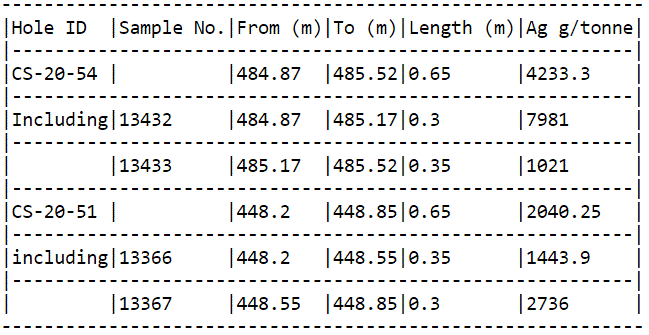
- – Significant silver intercept in hole CS-21-54 grading 7,981 g/tonne Ag (silver) (232.82 oz/ton) over 0.30m at a downhole depth of 484.87-485.17m with a gold equivalent grade of 3.25 oz/ton Au (111.41 g/tonne Au). The intersection is 15 m down dip from the pilot intercept in hole CS-20-39.
- – Another silver intercept in hole CS-21-51 grading 2,736 g/tonne Ag (silver) (79.81 oz/ton) over 0.30m at a downhole depth of 448.55-448.85m with a gold equivalent grade of 1.11 oz/ton Au (38.21 g/tonne Au). The intersection is 6 m down dip from the pilot intercept in CS-20-39.
- – We believe that these two intersections belong to the same structure as Big Silver. Intercepting this zone again from surface drilling increases the Company’s confidence in its geologic model and demonstrates the continuity of this structure – expanding the zone by a total of 15 meters.
With CS-20-51 and CS-20-54 containing valuable intercepts to the expansion of Big Silver and to the Robinson Zone area, the Company is developing a better understanding of these vein systems and will continue to explore the veins from surface and with wedge drilling.
Note: Gold equivalent is calculated based on USD $25.17 oz/ton Ag and USD $1802.30 oz/ton Au as of July 23 rd 2021.
Table 1 : Sample Details
Ongoing drilling in the Castle East area is geared toward identifying new veins to enable significant expansion to the existing resource panels outlined in the Company’s maiden Resource Estimate reported in a news release May 28, 2020. The Resource Estimate identified zones 1A and 1B of the Robinson Zone with an average silver grade of 8,582 g/t ( 250 oz/ton ) in a combined 27,400 tonnes of material for a total of 7.56 million Inferred ounces of silver using a cut-off grade of 258 g/t AgEq (mineral resources that are not mineral reserves do not have demonstrated economic viability). Report reference: Rachidi, M. 2020, NI 43-101 Technical Report Mineral Resource Estimate for Castle East, Robinson Zone, Ontario, Canada , with an effective date of May 28, 2020 and a signature date of July 13, 2020.
Location
The Castle Property is 15 km east of Aris Gold Corp’s Juby gold deposit, 30 km due south of Alamos Gold’s Young-Davidson mine, 75 km southwest of Kirkland Lake Gold’s Macassa Complex, and 100 km southeast of new gold discoveries in the Timmins West area.
Qualified Person
The technical information in this news release was prepared under the supervision of Mr. Matthew Halliday, P.Geo., (APGO), President, COO and VP Exploration of Canada Silver Cobalt Works Inc., a qualified person in accordance with National Instrument 43-101.
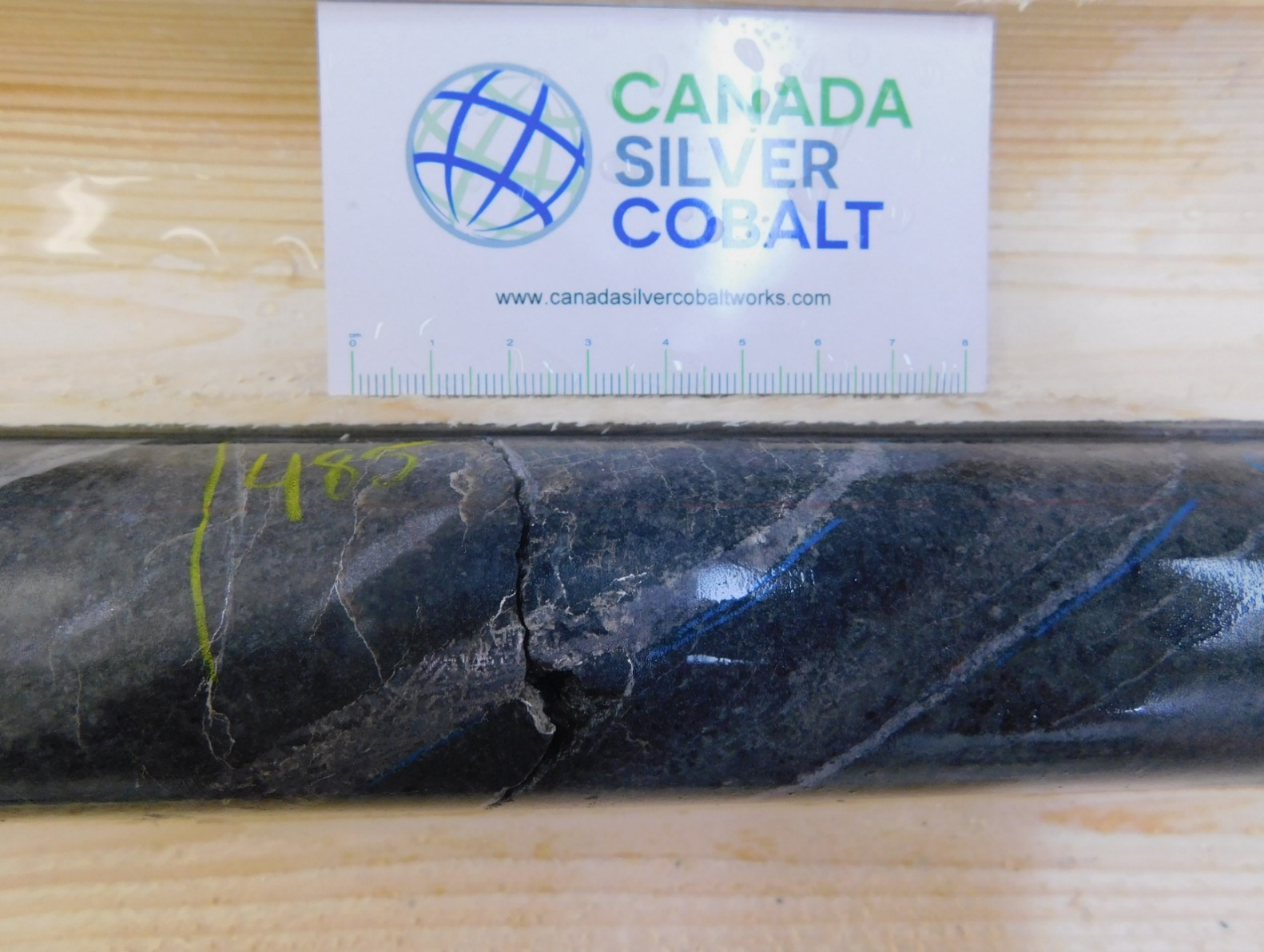
Figure 1: Silver and cobalt mineralization in hole CS-21-54 (7,981 g/tonne Ag)
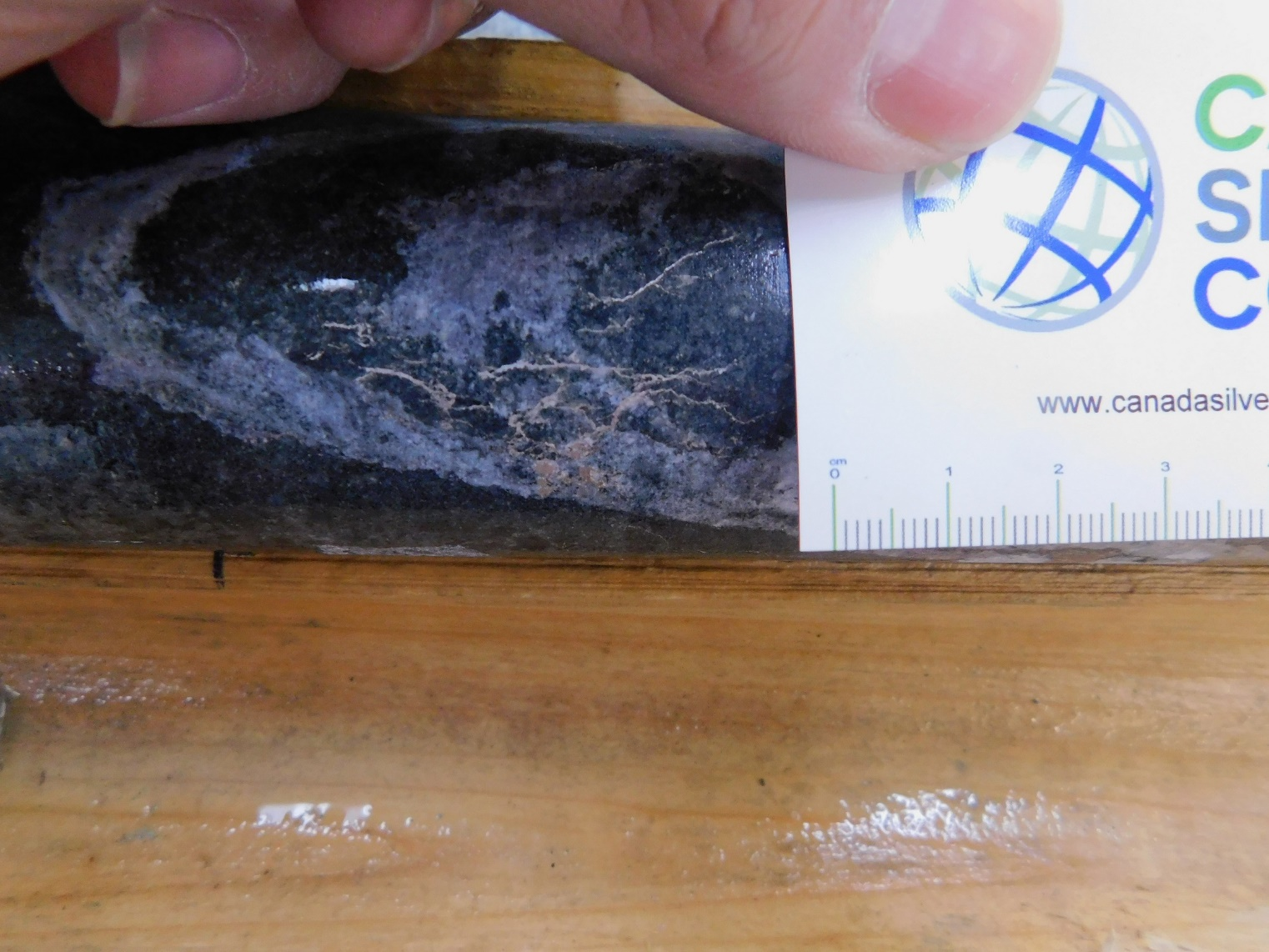
Figure 2: Silver and cobalt mineralization in hole CS-21-51 (2,736 g/tonne Ag)
About Canada Silver Cobalt Works Inc.
Canada Silver Cobalt Works Inc. recently discovered a major high-grade silver vein system in the Castle East area 1.5 km from the past-producing Castle Mine near Gowganda, Ontario in the prolific high-grade Silver District of Northern Ontario. The Company released the first-ever resource in the Gowganda Camp and greater Cobalt Camp in May 2020. A total of 7.56 million ounces of silver in Inferred resources, comprising very high-grade silver ( 8,582 grams per tonne un-cut or 250.2 oz/ton) in 27,400 tonnes of material from two sections (1A and 1B) of the Castle East Robinson Zone beginning at a vertical depth of approximately 400 meters, was identified. The discovery remains open in all directions (1A and 1B are approximately 800 meters from the Capitol Mine workings) (mineral resources that are not mineral reserves do not have demonstrated economic viability) (refer to Canada Silver Cobalt Works Press Release May 28, 2020. Report reference: Rachidi, M. 2020, NI 43-101 Technical Report Mineral Resource Estimate for Castle East, Robinson Zone, Ontario, Canada , with an effective date of May 28, 2020 and a signature date of July 13, 2020).
Canada Silver Cobalt’s flagship silver-cobalt Castle mine and 78 sq. km Castle Property feature strong exploration upside for silver, cobalt, nickel, gold, and copper. With underground access at Castle, an exceptional high-grade silver discovery at Castle East, a pilot plant to produce cobalt-rich gravity concentrates on site, a processing facility (TTL Laboratories) in the town of Cobalt, and a proprietary hydrometallurgical process known as Re-2Ox for the creation of technical-grade cobalt sulphate as well as nickel-manganese-cobalt (NMC) formulations, Canada Silver Cobalt is strategically positioned to become a Canadian leader in the silver-cobalt space.
“Frank J. Basa”
Frank J. Basa, P. Eng.
Chief Executive Officer
For further information, Contact:
Frank J. Basa, P.Eng.
Chief Executive Officer
416-625-2342
- Published in Canada Cobalt Works, Mining, News Home
Canada Silver Cobalt Receives Drill Permit for its EV Battery Metals Graal Property in Northern Lac St-Jean, Quebec
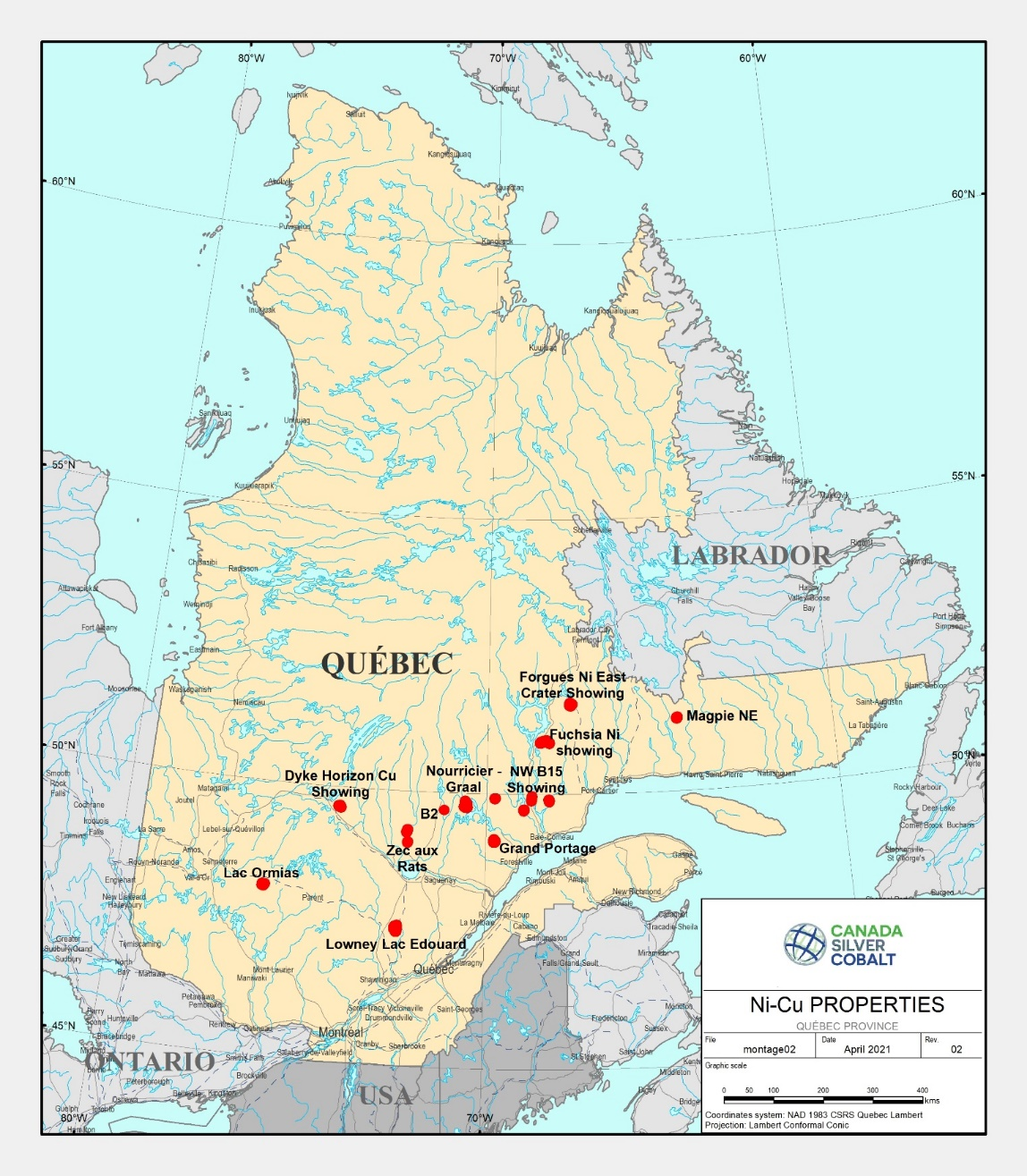
Canada Silver Cobalt Works Inc. (TSXV:CCW) (OTC:CCWOF) (Frankfurt:4T9B) (the “Company” or “Canada Silver Cobalt”) is pleased to provide an update on its early-stage exploration activities in the Province of Québec where it is evaluating 15 properties on 689 claims covering 38,129.4 hectares that are prospective for EV battery metals nickel, copper, and cobalt. (see Figure 1 below and February 16 and April 21, 2021 news releases).
The Company has now received its drill permit in order to drill the Bouguer Anomalies Targets of its Graal-Nourricier – Lac Suzanne property in northern Lac St-Jean. This property, which has not been fully explored, is one of the five included in the company’s geophysical airborne surveys conducted earlier this year and it is regarded as, geologically, one of the most promising. The Company is seeking to identify significant amounts of nickel-copper-sulphide masses at the base of the magnetic chamber.
The drill program is scheduled to start in the next 30 days and, in particular, seeks to intersect the base of the hidden magmatic reservoir of immiscible sulfides bath. Past drill results appear to be indicating mineralization on the side of the magmatic reservoir and the massive sulphides are potentially still hidden at depth.
The property has shown numerous metal intercepts from past drilling/sampling with the best results recording grades of up to 10.31% nickel, 4.9% copper and 1% cobalt from diamond drilling (see details below).
CEO Frank J. Basa, P.Eng., notes: “The company’s main focus remains the past-producing silver-cobalt Castle property in northern Ontario and especially the ongoing exploration of the Castle East exceptional high-grade silver discovery with drill intercepts up to 89,853 g/t Ag or 2,621 oz/ton and an initial resource of 7.6 million oz Ag with an average grade of 8,582 g/t Ag or 250.2 oz/ton (see details below). The Castle East exploration drill program is going well with 39,000 meters of the 60,000-meter program completed with numerous results pending and we expect a major increase in estimated silver resources in an update of the Resource Estimate expected in early 2022.
“The Quebec properties were acquired for their potential to host a variety of EV battery metals including nickel, copper and cobalt with the intention of expanding our current holdings and strategically positioning the Company and its shareholders to take full advantage of the evolving market conditions for EV battery base metal inputs. We are undertaking first-stage geological evaluation of the properties and, as previously announced, we are considering a potential transfer of the properties into another public company focused primarily on EV battery metals with our key precious metals assets remaining in Canada Silver Cobalt,” Mr. Basa stated
The first conceptual primary target identified based on Bouguer airborne survey conceptual modelling has an extent of 1200m x 2200m on the Graal-Nourricier – Lac Suzanne property. The unknown is the elevation – or the depth at which the base of the net-textured and massive sulfides sits. The geological team believes it should be intersected at a depth range of 1500 to 2000m from surface over 100 to 150 meters thick. If the Company succeeds in the first target, the drill will be moved to define near-surface targets prior to moving to a second target of lesser magnitude in size. This plan is subject to change and depends of the findings.
For the drill program, the Company has retained the services of Saguenay-based Laurentia Exploration, which has an extensive technical knowledge of the regional geology since several members of their crew have already worked on drill programs at the adjacent Arianne Phosphate lac à Paul project. The exploration work will be under the direction of GoldMinds Geoservices which has identified the targets.
Once drilling at Graal has started, the Company will follow up its exploration plan with drilling on the other main first-level targets at:
- – Lowney, Lac Edouard South-East- Forgues East Manic Crater- Fuchsia-Massif du Nord- B15 Bouguer anomaly
The program also includes verification with field geology for the second-level properties.
The Company is not pursuing the option agreement on the B2 property as the completed drill program there has not delivered expected results in comparison to the surface sample results.
Click Image To View Full Size
Figure 1 – Nickel – Copper Property Locations in the Province of Québec
About Graal – Nourricier Lac Suzanne property
The Graal-Nourricier – Lac Suzanne property is one of the most promising magmatic reservoirs identified in the group of recently acquired properties. The Company’s intention is to drill directly on the maximum Bouguer Anomaly identified. Below are some highlights (mostly historical data retrieved from public reports and information on SIGEOM) where we are of the opinion that the results to date are only mineralization on the side of the magmatic reservoir and the massive sulphides are still hidden at depth.
This property, comprising 71 CCW claims over 3,947 hectares and 23 optioned claims from Globex comprised of 3 distinct blocks totaling 1,276 hectares for a combined total of 5,223 hectares, is the most promising target. It is southeast of the Lac à Paul Arianne Phosphate deposit. The property is located approximately 160 kilometers NNE of the city of Saguenay and 272 kilometers east of Chibougamau in NTS 22E15. The central and southern claim blocks are underlain by anorthosites, gabbros and troctolites pertaining to the anorthositic suite of Lac-St-Jean, whereas the northern block is underlain by tonalitic and trondhjemitic gneisses pertaining to the Rouvray gneissic Complex.
Previous work on the Lac Suzanne property was performed by Mines d’Or Virginia Inc. between 1997 and 2001. This work consisted of airborne geophysical surveys (magnetic and electromagnetic) followed by ground surveys (magnetic and electromagnetic – MaxMin) in order to more precisely locate the anomalies that were outlined by the airborne surveys. These surveys were followed by geological mapping, trenching, blasting, soil geochemical and rock sampling. The last exploration work done, within the limits of the present claims, consisted of diamond drilling where 13 holes were drilled totaling 1,473 meters. The MaxMin survey delineated a good electromagnetic conductor over a strike length of over 6.5 kilometers which has only been sparsely explored, with up to 800 meters drill hole spacing or more and the deepest hole investigated at merely a 100 meters vertical depth. Knowing this, there remains a lot of ground to investigate more thoroughly.
The best results from the rock and drill core sampling returned grades of up to 10.31% Nickel, 4.9% Copper and 1% Cobalt from diamond drilling . The mineralization found on the Lac Suzanne property is of the magmatic massive sulphide type where sulphides are concentrated within a magmatic chamber. The Voisey’s Bay deposit in Labrador is of this same type. (for additional information regarding Voisey’s Bay deposit, please see: Current Research (2003) Newfoundland Department of Mines and Energy Geological Survey, Report 03-1, pages 231-239 – VOISEY’S BAY AND THE NICKEL POTENTIAL OF LABRADOR: A SUMMARY FOR THE NONSPECIALIST by A. Kerr Voisey’s Bay 2003 A. Kerr Report ). The exploration work done on the Lac Suzanne property thus far has barely scratched the surface. As exploration deepens, there is a good chance that richer grades may be encountered. There are many identified, near-surface mineralized zones which dip toward the Bouguer Anomaly sweet spot.
On the Nourricier portion, there is Nourricier A (97-01), A (97-c235), B (NB 97-01) B (NB97-02) sector. T he hole collar NA-97-01 (GM 56023 – Rapport des Travaux 1997, Mines d’Or Virginia) locates the deposit. It is near the RT-97-C238 trench which revealed even higher grades. “Recognized intrusive brec cias in the Feeder (Nourricier) Sector (A and B) with fragments of olivine containing droplets of sulphides indicating crystallization of olivines in a sulphide bath are strongly similar to mineralization at Voisey’s Bay”.
The host rock is gabbro or anorthosite injected with levels of pyrrhotite which give the rock an appearance of breccia. The mineralization consists of disseminated to massive pyrrhotite (max 70%) sometimes accompanied by chalcopyrite (1% or less) and garnet (35%, when the matrix is gabbro, at 45.5 m in the hole). Magmatic mineralization, dominant Nickel-Copper (± Cobalt ± PGE), is associated with anorthositic-troctolitic massifs .
MHY A (97-03) MHY (97-02) Occurrence (Lac Suzanne property) (source: GM 71373 – Compilation Report, Lac Suzanne Property, Globex Mining Enterprises, 2019)
Highlight:
MHY-97-02: 0.21% Copper, 0.22% Nickel and 338 ppm Cobalt over 0.6 m to 22.5 m; 0.12% Copper, 0.27% Nickel and 395 ppm Cobalt over 0.3 m to 34.8 m; Blasting: RT-97-C319: 0.18% Copper, 0.2% Nickel and 319 ppm Cobalt; Blasting FL-97-C 15: 0.1% Copper, 0.28% Nickel and 900 ppm Cobalt (smp689824); 0.62% Copper, 0.13% Nickel and 276 ppm Cobalt (smp689751); 0.53% Copper, 0.09% Nickel and 171 ppm Cobalt (smp689753).
MHY-97-03: 1447 ppm Copper, 5143 ppm Nickel and 533 ppm Cobalt over 0.6 m to 16.4 m; 0.6% Copper over 0.8 m to 12.3 m; SM-97-C-21: 0.52% Copper and 0.06% Nickel; RT-97-C-240: 0.22% Copper; RT-97-C-245 (400 m to the southwest): 0.34% Copper and 0.12% Nickel. GM 59143: drillhole 1279-01-35 (360 m to the northeast): 0.37% Nickel, 0.18% Copper and 0.04% Cobalt over 4.3 m including 0.95% Nickel over 0.5 m.
Lac Suzanne North
Occurrence of massive sulphide veins.
Highlight: The best values from hole 1279-01-37 show 0.29% Nickel, 0.05% Copper and 0.03% Cobalt over 1.0 m; 0.3% Copper over 0.3 m; 12.65% TiO 2 , 13.16% MgO and 0.2% P 2 O 5 over 30.6 m
Lac Suzanne
The mineralization occurs in the form of massive sulphide veins intersecting massive and very homogeneous units of amphibole anorthosite and leucogabbro.
Highlight: Drill hole 1279-01-36 has 10.31% Nickel, 0.06% Copper and 0.05% Cobalt over 0.3 m, as well as 0.14% Nickel, 4.27% Copper and 0.03% Cobalt over 1.0 m. This interval corresponds to a centimetric vein of sulphides rich in chalcopyrite intersecting the drillhole at a low angle.
Qualified person
The technical information in this news release has been reviewed by Claude Duplessis, P.Eng., GoldMinds Geoservices Inc. m ember of Québec Order of Engineers and a qualified person in accordance with National Instrument 43- 101 standards.
About Canada Silver Cobalt Works Inc.
Canada Silver Cobalt Works released the first-ever resource in the Gowganda Camp and greater Cobalt Camp in May 2020. A total of 7.56 million ounces of silver in Inferred resources, comprising very high-grade silver ( 8,582 grams per tonne un-cut or 250.2 oz/ton) in 27,400 tonnes of material from two sections (1A and 1B) of the Castle East Robinson Zone beginning at a vertical depth of approximately 400 meters, was identified. The discovery remains open in all directions (1A and 1B are approximately 800 meters from the Capitol Mine workings) (mineral resources that are not mineral reserves do not have demonstrated economic viability) (refer to Canada Silver Cobalt Works Press Release May 28, 2020. Report reference: Rachidi, M. 2020, NI 43-101 Technical Report Mineral Resource Estimate for Castle East, Robinson Zone, Ontario, Canada , with an effective date of May 28, 2020 and a signature date of July 13, 2020).
Canada Silver Cobalt’s flagship Castle mine and 78 sq. km Castle Property feature strong exploration upside for silver, cobalt, nickel, gold, and copper in the prolific past-producing Gowganda high-grade Silver District of Northern Ontario. With underground access at Castle, an exceptional high-grade silver discovery at Castle East, a pilot plant to produce cobalt-rich gravity concentrates on site, a processing facility (TTL Laboratories) in the town of Cobalt, and a proprietary hydrometallurgical process known as Re-2Ox for the creation of technical-grade cobalt sulphate as well as nickel-manganese-cobalt (NMC) formulations, Canada Silver Cobalt is strategically positioned to become a Canadian leader in the silver-cobalt space.
“Frank J. Basa”
Frank J. Basa, P. Eng.
Chief Executive Officer
For further information, Contact:
Frank J. Basa, P.Eng.
Chief Executive Officer
416-625-2342
- Published in Canada Cobalt Works, Mining, News Home
Enduro Commences 10,000 Metre Drill Program at Newmont Lake Project, Golden Triangle, NW British Columbia
Enduro Metals Corporation (TSXV: ENDR) (OTCQB: ENDMF) (FSE: SOG) (“Enduro Metals” or the “Company“) announces that the first diamond drill rig is now drilling on the Newmont Lake property in the heart of BC’s prolific Golden Triangle. A second drill rig will be added in early August. The planned “base case” drill program is 10,000 metres, with potential to expand. Enduro recently upgraded its on-site infrastructure to enable a prolonged exploration season.
The Company is presently conducting its initial drilling at Chachi with several other targets to be drilled this season.
Enduro’s CEO Cole Evans stated: “There are several high-quality untested targets across our large land package providing multiple paths to a major discovery. We are delighted to be back on the ground and drilling again and excited to build on what we have learned over the past three years. We are optimistic that we will see exciting results from this season’s drilling.”
CHACHI CORRIDOR
The Chachi Corridor represents a multi-element system endowed in copper, silver, gold, lead, zinc, nickel, and cobalt which was discovered by Enduro in 2019. This extensive system, spanning more than 5 kilometers, has characteristics of multiple deposit types, including alkalic porphyry, epithermal, skarn and possibly Iron-Oxide Copper Gold (“IOCG”) ore deposits. Intrusions are of the same age as the nearby Galore Creek deposit, which is being advanced by a joint venture between Newmont Corporation and Teck Resources Limited.
This initial drilling will involve 6 holes from 3 separate drill pads, with targets selected based on:
- High-grade copper-silver on surface (including rock samples with 5.3% copper/36 g/t silver and 2.7% copper/301 g/t silver);
- Induced polarization (“IP”) geophysic chargeability responses;
- Proximity to a regional structural feature; and
- Widespread alteration.
The holes are intended to track the high-grade values from surface and will provide the first sub-surface information in the Chachi Central Zone (CCZ).

Cole’s Notes Episode 2: ‘Enduro’s Drill Program Commences’ – Enduro’s 2021 Video Series: https://youtu.be/DtgpiupNxXk
To view an enhanced version of this graphic, please visit:
https://orders.newsfilecorp.com/files/6406/90866_44674ea49449191c_002full.jpg
BURGUNDY/72 ZONE
An important focus this year will be drilling the Burgundy/72 region, 13km west of the Chachi Corridor. A first-pass drill program in 2019 intersected mineralization in several shallow holes including 91m of 0.38% Cu and 0.30 g/t Au starting at 36m downhole. Late in the 2019 season, a trench 400 metres south cut 1.3% Cu, 1.5 g/t Au, 23 g/t Ag, and 3% Zn over 37m with the mineralized zone remaining open.
Another mineralized zone 2.3km to the northeast is now being further investigated using advanced hyperspectral techniques to vector within the extensive zone of alteration and mineralization. This area is being explored as an alkalic porphyry target. Previous drill results include 22m of 0.89% Cu, 0.71 g/t Au, 0.26 g/t Pd, and 6.6 g/t Ag within a broader mineralized interval.
Work over the winter by the Charles Fipke Centre for Innovative Research at University of British Columbia (Okanagan) dated intrusive rocks in this area as coeval to the Galore Creek.
Surface work presently underway will fine-tune target locations for drilling this season, with the objective of confirming the presence of a large-scale copper-gold alkalic porphyry system.
CUBA ZONE
The Cuba zone is characterized by a 4km long trend of silver-lead-zinc-copper mineralization, characterized as both carbonate replacement and epithermal-type systems. The Havana target, identified by Enduro last year, is located at the northern end of the previously outlined trend. A sample from one of the quartz-barite veins in the Havana Zone assayed 1,277 g/t silver, 4.51% copper, 1.11% zinc, and 0.21% lead. An IP geophysical survey line over the target identified an anomaly coincident with the surface geochemical anomaly.
The initial two drill holes will test the area of coincident geochem and the IP chargeability high.
McLYMONT FAULT
The McLymont Fault was the focus of much of the previous historic and Enduro’s latest work in this area, including outlining a gold-copper resource at the NW Zone. Work by Enduro has outlined gold mineralization along 20 km of the fault zone in the McLymont Fault area. Enduro’s drilling has extended the historic NW Zone along strike and to depth and has identified parallel mineralized features. Enduro’s drill results outside of the previously identified mineralized area includes drill hole NW20-09 in the Northeast Extension which intersected 31 g/t Au and 1.07% Cu over 8.8 metres.
Further drilling this year will continue to expand on the known extent of the main mineralized zones and aim to test a potential underlying porphyry system.
Specifically, 2021 drilling will:
- Test the deeper extent of porphyry style mineralization encountered in 2020 drilling.
- Expand on initial Troy Vein discovery (32.5 g/t Au and 1.07% Cu over 8.9 m).
- Test satellite high-grade gold trends along the greater McLymont Fault Corridor.
Camp, Infrastructure and Access Upgrades
The airstrip has just been extended to allow access for larger aircraft. The camp is being upgraded to allow for exploration work to continue later in the winter season. Surveying work is underway to establish an improved winter road into the Newmont Lake Camp, which will allow bulk supplies to be brought in on surface.
Diamond Drilling
Drilling services for the 2021 drill program are being provided by HELM Diamond Drilling Ltd. (“HELM”), 100% indigenous owned and operated by Alan McPherson, a Tahltan Nation member and Devlin Luck, a Mi’kmaq Nation member. McPherson and his team carried out Enduro’s last two seasons of drilling and have over 35 years collective experience drilling other projects in the district.
Qualified Person
The technical information in this news release has been reviewed and approved by Mr. Maurizio Napoli, P. Geo., Director for Enduro Metals, a Qualified Person responsible for the scientific and technical information contained herein under National Instrument 43-101 standards.
About Enduro Metals
Enduro Metals is an exploration company focused on it’s flagship Newmont Lake Project; a total 638km2 property located between Eskay Creek, Snip, and Galore Creek within the heart of northwestern British Columbia’s Golden Triangle. Enduro entered into an option agreement to acquire 436km2 from Romios Gold Resources who has carefully consolidated the area since 2005. Building on prior results, the Company’s geological team have outlined 4 deposit environments of interest across the Newmont Lake Project including high-grade epithermal/skarn gold along the McLymont Fault, copper-gold alkalic porphyry mineralization at Burgundy, high-grade epithermal/skarn silver/zinc at Cuba, and a large 9km x 4km geochemical anomaly hosting various gold, silver, copper, zinc, nickel, cobalt, and lead mineralization along the newly discovered Chachi Corridor.
On Behalf of the Board of Directors,
ENDURO METALS CORPORATION
“Cole Evans“
President/CEO
For further information please contact:
Investor Relations
Sean Kingsley – Director of Communications
Tel: +1 (604) 440-8474
- Published in Enduro Metals Corp., Mining, News Home
Sonoro Gold Reports Surface Sampling Materially Extends Oxide Gold Mineralized Zones & Announces Priority Targets for Fall 2021 Drill Campaign
Sonoro Gold Corp. (TSXV: SGO | OTCQB: SMOFF | FRA: 23SP) (“Sonoro” or the “Company”) is pleased to report assay results from surface sampling recently completed at the Company’s Cerro Caliche gold project, located in Sonora State, Mexico. The results confirm material extensions of several of the project’s oxide gold mineralized zones and demonstrate linear structural corridors of anomalous gold, silver, and base metal mineralization.
This ongoing surface sampling program will be part of the foundation for the upcoming drilling program designed to materially expand and categorize the project’s oxide gold mineralization.
The following maps shows the locations of the surface samples and mineralized corridors referenced in this news release.
A Media Snippet accompanying this announcement is available by clicking on the image or link below
Highlights:
- Collected 1,292 soil and surface rock samples from several well-defined vein and gold mineralized, structural corridors.
- Surface sampling methods consist of continuous chip sampling perpendicular across measured veins and wall rocks.
- Confirmed 600-meter southern extension of the El Colorado – La Ventana Corridor; assay results returned 23.7 meters averaging 1.7 grams of gold per tonne (“g/t Au”), including 5.5 meters averaging 6.0 g/t Au; 8.0 meters averaging 0.6 g/t Au.
- Confirmed 750-meter southern extension of the Buena Suerte – San Quintin Corridor; assay results returned 52.6 meters averaging 0.2 g/t Au including 2.6 meters averaging 2.2 g/t Au; 8.0 meters averaging 0.8 g/t Au; 1.0 meters averaging 9.4 g/t Au.
- High silver content identified at La Magdalena from the northeastern La Magdelena – La Española corridor; assay results returned 1 meter averaging 1,230 g/t Ag with 6.6 g/t Au.
The following map shows four southern vein and gold mineralized corridors with selected assays and target zone for the upcoming drilling campaign.
A Media Snippet accompanying this announcement is available by clicking on the image or link below
The following map shows two gold bearing northeastern corridors with high silver contents, a common character of Low Sulfidation mineralization at higher levels in the boiling zones.
A Media Snippet accompanying this announcement is available by clicking on the image or link below
Sampling will continue to focus on near surface mineralized structures which outcrop from thick soil and alluvium and is associated with detailed geological mapping completed in preparation of the upcoming drilling program, scheduled to commence in the fall of 2021. To date, the Company has drilled and assayed results from over 34,500 meters of drilling, including a 24,221-meter Phase III drill program completed in the spring of 2021. When combined with historical data, total exploration at Cerro Caliche totals over 47,500 meters, 433 drill holes and 9,365 surface samples.
Drilling activities on the concession have been paused since May 2021 pending financing and to provide the exploration team sufficient time to ensure all data and assistance was available for the completion of two independent NI 43-101 technical reports, scheduled to be filed by mid-August 2021. As previously announced, the Company engaged Micon International Ltd. to prepare an updated Technical Report and D.E.N.M. Engineering Ltd. to prepare a Preliminary Economic Assessment (PEA).
These reports are expected to expand the resource size and upgrade the classification of Cerro Caliche’s identified mineralization and confirm if it is sufficient to support the Company’s proposed HLMO with an initial operating capacity of up to 15,000 tons per day (tpd).
Exploration at Cerro Caliche has identified a broadly mineralized low-sulphidation epithermal vein structure and the presence of multiple northwest trending gold mineralized zones along trend and near surface. As discussed in the Company’s revised Cerro Caliche Project Development Report (“PDR”) and announced in a related news release date May 26, 2021, the current exploration program was designed to test an exploration target of between 75,000,000 to 100,000,000 tonnes with grades potentially between 0.3 g/t to 0.5 g/t AuEq. This is in addition to the estimated inferred resource of 11.5 million tonnes at an average grade of 0.495 g/t gold and 4.3 g/t as stated in the initial NI 43-101 Technical Report1 filed in July 2019.
The reader is cautioned that the potential tonnages and grades in the PDR are conceptual in nature, as at the time of the report’s issue there had been insufficient exploration to define a mineral resource and it was uncertain if further drilling would result in the target being delineated as a mineral resource.
With a limited amount of the property’s mapped gold mineralized zones having been drilled and assayed to date, the upcoming drilling program will strategically target a 750-meter zone along the southern extensions of the El Colorado – La Ventana and Buena Suerte – San Quintin corridors where extensive surface samplings and geological mapping suggests the potential for material expansion of the oxide gold mineralization.
Mel Herdrick, Sonoro’s VP of Exploration noted, “The sampling and mapping program is producing important new data that, when added to Sonoro’s database, significantly assists our ability to locate drill targets and prioritize our drilling, which is anticipated to resume this fall. Previous drilling intercepted gold mineralization in most holes, demonstrating a very good success rate, which I expect will continue in the mineralized zone corridors. I also expect that ongoing sampling at the higher ridge zones to the northeast will show a continuation of gold mineralization that has been previously defined, and as it does, it should lead to additions of mineralized material, especially at El Bellotoso, and El Desprecio, as well as La Española.”
Kenneth MacLeod, Sonoro’s President and CEO added, “The sampling data cited in this news release, together with the additional sampling awaiting assaying, will be instrumental in supplementing recommendations for future exploration to be outlined in the upcoming PEA, anticipated to be released in August. Sonoro is scheduling the next phase of drilling to commence this fall.”
John Darch Sonoro’s Chairman commented, “This sampling program and the highly encouraging results are one of the key components of management’s strategy to develop the conceptual heap leach mining operation and, if successful, to use the cash flow to fund our on-going drilling program and continue expanding already known gold resources and the proposed mine’s rate of production. Our efforts to date have tested barely 20% of the known mineralized zones and I look forward to reporting to our shareholders additional results from this program as well as our upcoming drilling program.”
Quality Assurance/Quality Control (“QA/QC”) Measures and Analytical Procedures
Samples are collected as continuous chip samples by hand into plastic bags, GPS positions and rock descriptions noted, the bags are numbered using ALS-Chemex bar code number books, then sealed and taken to secure storage in Cucurpe village near the project.
Company personnel transport those bagged samples directly to the preparation laboratory of ALS- Chemex in Hermosillo, Sonora. At the preparation laboratory samples are logged into ALS-Chemex system using bar code labels, opened, then reduced in size through crushing, splitting and pulverization. About 200 grams of each sample are sent by ALS-Chemex to their Vancouver, Canada laboratory where samples are individually dissolved in aqua regia for multi-element ICP analysis, including silver. Thirty grams of each pulverized sample is split apart in that laboratory and undergoes a “Fire Assay” for gold content by reducing the fire assay to a concentrated button of material that is dissolved in acids and from the solution, the gold content is determined by atomic absorption. Quality control standards were inserted by the ALS-Chemex, Vancouver, B.C. laboratory.
No QA/QC issues were noted with the results received from the laboratory.
Geologic Description
Cerro Caliche is located 45 kilometers east southeast of Magdalena de Kino in the Cucurpe-Sonora Mega-district of Sonora, Mexico. Multiple historic small underground gold mines were developed in the concession including Cabeza Blanca, Los Cuervos, Japoneses, Las Abejas, Boluditos, El Colorado, Veta de Oro and Espanola. Mineralization types of the Cucurpe-Sonora Mega-district include variants of epithermal low sulfidation veins and related mineralized dikes and associated volcanic domes. Local altered and mineralized felsic dikes cut the mineralized meta-sedimentary rock units and may be associated with mineralization both in the dikes and meta-sedimentary rocks.
Qualified Person Statement
Stephen Kenwood, P.Geo., a Director of Sonoro, is a Qualified Person within the context of National Instrument 43-101 (NI 43-101) and has read and approved this news release. Readers are cautioned that the presence of mineralization on historic mines adjacent to or on Cerro Caliche is not necessarily indicative of economic gold mineralization in the concessions held by the Company.
About Sonoro Gold Corp.
Sonoro Gold Corp. is a publicly listed exploration and development company holding the near development stage Cerro Caliche project and the exploration stage San Marcial properties in Sonora State, Mexico. The Company has highly experienced operational and management teams with proven track records for the discovery and development of natural resource deposits.
On behalf of the Board of Sonoro Gold Corp.
Per: “Kenneth MacLeod”
Kenneth MacLeod
President & CEO
For further information, please contact:
Sonoro Gold Corp. – Tel: (604) 632-1764
Email: info@sonorogold.com
- Published in Mining, News Home, Sonoro Gold
TRU Precious Metals Continues Consolidation at its Flagship Golden Rose Project in Central Newfoundland
TRU Precious Metals Corp. (TSXV: TRU) (OTCQB: TRUIF) (FSE: 706) (“TRU” or the “Company”) is pleased to announce it has entered into an asset purchase agreement (the “Purchase Agreement”) to acquire a claims package (the “Purchased Assets”), along with related permits and technical data, contiguous with the Company’s flagship Golden Rose Project in Central Newfoundland’s Gold Belt. The Purchased Assets are comprised of five licences (45 claims) covering 1,125 hectares. Portions of the Purchased Assets are located along trend from the 550m long South Wood Lake Gold Zone and provides additional coverage should the gold zone extend onto the land comprising the Purchased Assets. Additionally, certain historic drill holes have been collared on the Purchased Assets targeting the Sure Shot and Hill Top gold occurrences found at the Company’s Golden Rose Project, which are located within a few hundred meters of the Purchased Assets.
Joel Freudman, Co-Founder and CEO of TRU, commented: “Consistent with TRU’s stated strategic objective of continuing the expansion and addition of properties of merit along the Shear Zone, this acquisition is further cementing our rapid growth at our flagship Golden Rose Project. Golden Rose is prime real estate for TRU and adding to our land position is key to TRU’s strategic objectives.”
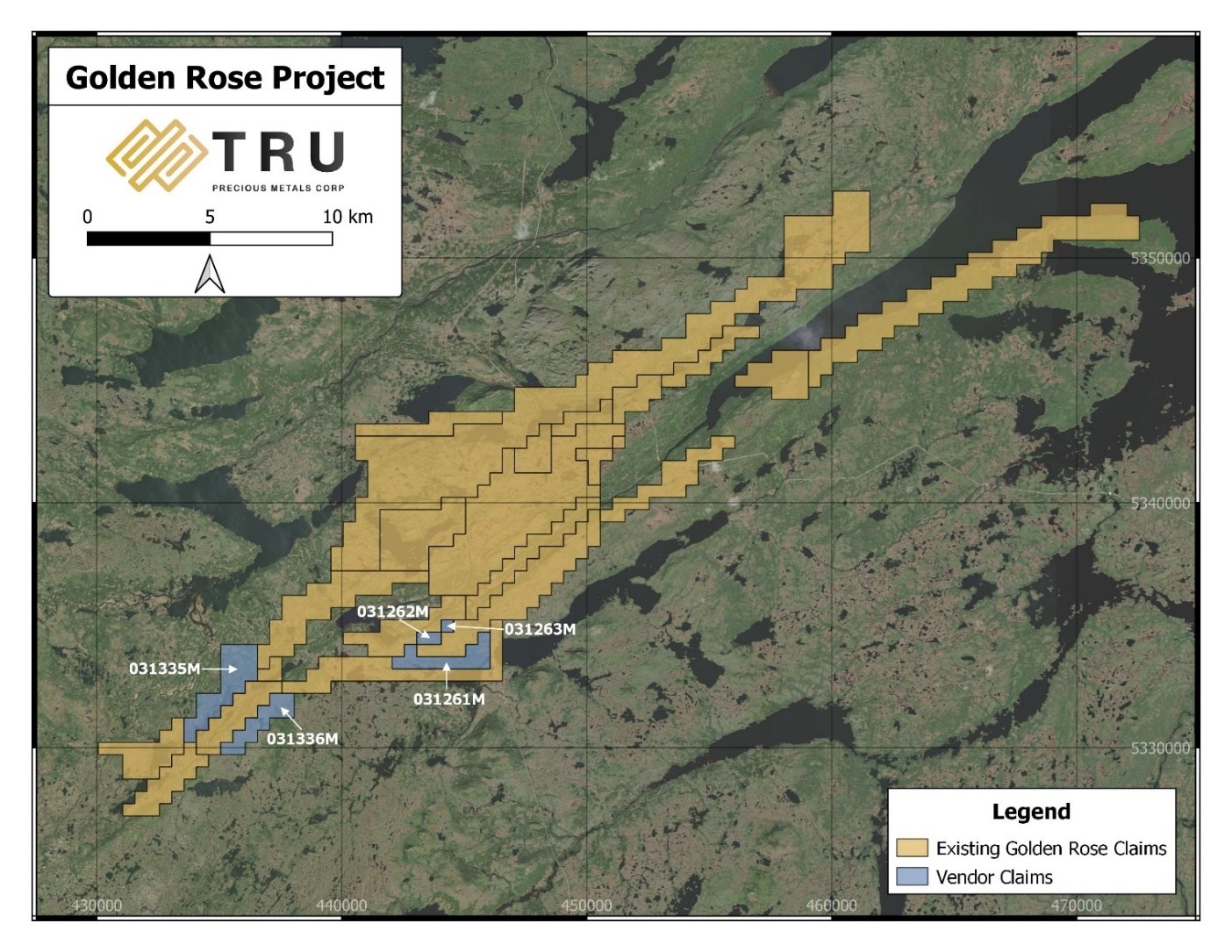
Figure 1: Location of licences comprising the Purchased Assets
To view an enhanced version of this graphic, please visit:
https://orders.newsfilecorp.com/files/5993/89778_2ea45cb0a48fba09_001full.jpg
Terms of the Purchase Agreement
Pursuant to the Purchase Agreement, the vendors will receive an aggregate of 80,000 common shares in the capital of TRU at a deemed price of $0.25 per share as consideration for the Purchased Assets. All TRU shares issuable under the Purchase Agreement will be subject to a hold period expiring four months and one day from the date on which such shares are issued.
The acquisition of the Purchased Assets remains subject to customary conditions. The transaction is expected to be completed as soon as is practicable based on governmental claims transfer processing times and remains subject to regulatory approval by the TSX Venture Exchange. The transaction is an “arm’s length transaction” as defined in the policies of the TSX Venture Exchange and no finder fees are being paid in connection therewith.
Barry Greene, P.Geo. is a qualified person as defined by National Instrument 43-101 and has reviewed and approved the contents and technical disclosures in this press release. Mr. Greene is a director and officer of the Company and owns securities of the Company.
About TRU Precious Metals Corp.
TRU has assembled a portfolio of 5 gold exploration properties in the highly prospective Central Newfoundland Gold Belt. The Company has an option with a subsidiary of TSX-listed Altius Minerals Corporation to purchase 100% of the Golden Rose Project, located along the deposit-bearing Cape Ray – Valentine Lake Shear Zone. TRU also owns 100% of the Twilite Gold Project, located along the same Shear Zone, and 3 under-explored properties including its Rolling Pond Property (under option) bordering New Found Gold Corp.’s high-grade Queensway Project. TRU’s common shares trade on the TSX Venture Exchange under the symbol “TRU”, on the OTCQB Venture Market under the symbol “TRUIF”, and on the Frankfurt exchange under the symbol “706”.
TRU is a portfolio company of Resurgent Capital Corp. (“Resurgent”), a merchant bank providing venture capital markets advisory services and proprietary financing. Resurgent works with promising public and pre-public micro-capitalization Canadian companies. For more information on Resurgent and its portfolio companies, please visit Resurgent’s LinkedIn profile at https://ca.linkedin.com/company/resurgent-capital-corp
For further information about TRU, please contact:
Joel Freudman
Co-Founder, President & CEO
TRU Precious Metals Corp.
Phone: 1-855-760-2TRU (2878)
Email: ir@trupreciousmetals.com
Website: www.trupreciousmetals.com
To connect with TRU via social media, below are links:
Facebook
https://www.facebook.com/TRU-Precious-Metals-Corp-100919195193616
Twitter
https://twitter.com/corp_tru
LinkedIn
https://www.linkedin.com/company/tru-precious-metals-corp
YouTube
https://www.youtube.com/channel/UCHghHMDQaYgS1rDHiZIeLUg/
- Published in Mining, News Home, Tru Precious Metals