Glen Eagle Sees New Opportunities Developing In Honduras
Glen Eagle Resources – TheNewswire – March 8, 2022 (TSX V :GER) (“Glen Eagle” the “Company”, or “GER”) has posted on its website a video showing the government’s position with regards to the mining industry in Honduras. The declaration states “that the companies operating with legal mining permits will continue their operations as usual but those working illegally or not compliant should be very concerned.” Glen Eagle applauds the leadership of the government.
Approximately 2000 small miners are working in the area where Cobra Oro is located. A majority of them are processing their ore using mercury for gold extraction and working without environmental permits.
Cobra Oro gold processing plant was originally built on the premises that the previous government would enforce the Minamata Agreement, which it signed in 2014 along with more than 100 countries to stop the use of mercury for gold extraction, a highly polluting metal, toxic and detrimental to people’s health living in the vicinity of these operations.
It was against this backdrop that Cobra Oro’ plant was built with the purpose to bring a solution to the small miners by having their ore brought to Cobra Oro and be processed in a regulated and safe environment.
The newly elected government of Xiomara Castro made environmental issues related to mining a central theme of her campaign, precluding a tougher approach towards illegal mining and permitting, which is welcomed by the Company and seen as opening many new opportunities to Cobra Oro in the near future and possibly vindicate the foundations upon which the plant was built originally.
Neither TSX Venture Exchange nor its Regulation Services Provider (as that term is defined in the policies of the TSX Venture Exchange) accepts responsibility for the adequacy or accuracy of this release.”
Jean Labrecque
Glen Eagle Resources Inc
2075 Victoria Street, Suite 201
St-Lambert, Quebec
J4S-1H1
514-808-9807
- Published in Glen Eagle, News Home
Canada Silver Cobalt Reports Positive Battery Metals Assay Results from its Massive Sulphide Discovery at Graal in Northern Quebec
Assay results confirm the existence of strong nickel, copper and cobalt mineralization in addition to discovering low grade platinum and palladium.
Coquitlam, BC – TheNewswire – March 3, 2022 – Canada Silver Cobalt Works Inc. (TSXV:CCW) (OTC:CCWOF) (Frankfurt:4T9B) (the “Company” or “Canada Silver Cobalt”) is pleased to announce it has received positive assay results including intercepts up to 2.08% nickel and 3.75% copper from the first three diamond drill holes that intercepted massive sulphides at its Graal property in the Lac St-Jean region of Quebec.
Highlights:
- The assay results (see table below) verify the existence of nickel and copper that was identified using a handheld XRF device during the core logging process (See November 24, 2021 news release).
- The elemental data suggests the pyrrhotite is nickel bearing and shows the existence of PGM elements including platinum and palladium.
- There are assays pending from another 18 drill holes.
- Massive sulphides were intercepted in 20 of 21 drill holes with 7,772.3 meters drilled to date.
- Another 1,700 meters of drilling is planned at Graal along with borehole EM geophysics to quantify potential thickness around the sulphide intersections and a ground EM survey (SQUID) to identify conductive zones to create high-value targets at depth (See news release January 31, 2022).
Matt Halliday, P.Geo., President, COO and VP Exploration stated: “Graal has been an exciting property for our geological team from the time we hit massive sulphides in the first few holes. As we drilled more holes, we discovered even wider intervals of sulphides. We’re very much looking forward to the assays from the remaining 18 holes that are still not reported and continuing with exploration at this deposit. With Graal and the other prospective properties we have in Quebec and Ontario, the Company is well positioned for the continued discovery of battery metals, and when combined with our ‘green’ Re-2Ox extraction process, to be a fully integrated, environmentally compliant supplier of critical metals and value-added battery metals to the North American market.”
Table 1: Drill core assay results
| DDH | From | To | Length (m) | Ni (%) | Cu (%) | Co (%) | Pt (g/t) | Pd (g/t) |
| NRC-21-02 | 155.00 | 171.00 | 16.00 | 0.10 | 0.70 | 0.01 | 0.01 | 0.01 |
| Including | 155.70 | 160.70 | 5.00 | 0.29 | 0.18 | 0.03 | 0.01 | 0.01 |
| NRC-21-03 | 138.30 | 144.00 | 5.70 | 0.84 | 0.59 | 0.09 | 0.03 | 0.03 |
| Including | 138.30 | 142.40 | 4.10 | 1.15 | 0.27 | 0.12 | 0.04 | 0.04 |
| Including | 143.40 | 144.00 | 0.60 | 0.10 | 3.75 | 0.02 | 0.00 | 0.00 |
| NRC-21-04 | 136.40 | 136.90 | 0.50 | 2.08 | 0.88 | 0.03 | 0.41 | 0.22 |
Please note: Intervals represent single assays and are core length with no capping applied.
The 6,113-hectare Graal property is one of 14 properties recently acquired in northern Quebec covering 31,201 hectares that are prospective for EV battery metals such as nickel, copper, and cobalt. (See February 16, April 21, July 22, November 15, 2021 and January 31, 2022 news releases). The drill program is currently being managed by Laurentia Exploration in association with GoldMinds Geoservices Inc.
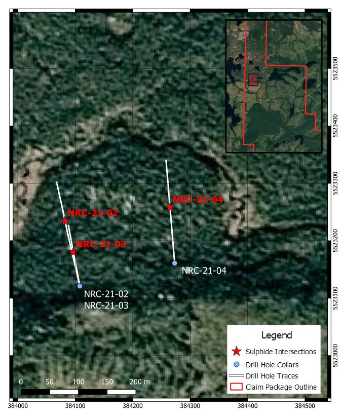
Click Image To View Full Size
Figure 1: Map of Property, Claims, Drill Holes, and Sulphide Intercept Locations.
QA/QC
The core samples were sent to ALS labs located in Val d’Or for sample preparation and will be forwarded to a separate lab for a four-acid digest multi-element suite including nickel and copper as well as a fire assay for platinum and palladium. Blank and standards were included in the sample batch and their values allows the public disclosure of the assay results.
Qualified person
The technical information in this news release has been reviewed by Claude Duplessis, P.Eng., GoldMinds Geoservices Inc., a member of the Quebec Order of Engineers, and is a qualified person in accordance with the National Instrument 43- 101 standards.
About Canada Silver Cobalt Works Inc.
Canada Silver Cobalt Works Inc. recently discovered a major high-grade silver vein system at Castle East located 1.5 km from its 100%-owned, past-producing Castle Mine near Gowganda in the prolific and world-class silver-cobalt mining district of Northern Ontario. This discovery has the highest silver resource grade in the world, with recent drill intercepts of up to 89,853 grams/tonne silver (2,621 oz/ton Ag). A drill program is underway to expand the size of the deposit with an update to the resource estimate scheduled for Q1 2022.
In May 2020, based on a small initial drill program, the Company published the region’s first 43-101 resource estimate that contained a total of 7.56 million ounces of silver in Inferred resources, comprising very high-grade silver (8,582 grams per tonne un-cut or 250.2 oz/ton) in 27,400 tonnes of material from two sections (1A and 1B) of the Castle East Robinson Zone, beginning at a vertical depth of approximately 400 meters. Note that mineral resources that are not mineral reserves do not have demonstrated economic viability. Please refer to Canada Silver Cobalt Works Press Release May 28, 2020, for the resource estimate. Report reference: Rachidi, M. 2020, NI 43-101 Technical Report Mineral Resource Estimate for Castle East, Robinson Zone, Ontario, Canada, with an effective date of May 28, 2020, and a signature date of July 13, 2020.
The Company also has 14 battery metals properties in Northern Quebec where it is currently drilling and the prospective 1,000-hectare Eby-Otto gold property close to Agnico Eagle’s high-grade Macassa Mine near Kirkland Lake, Ontario where it will be exploring in 2022.
Canada Silver Cobalt’s flagship silver-cobalt Castle mine and 78 sq. km Castle Property feature strong exploration upside for silver, cobalt, nickel, gold, and copper. With underground access at the fully owned Castle Mine, an exceptional high-grade silver discovery at Castle East, a pilot plant to produce cobalt-rich gravity concentrates on site, a processing facility (TTL Laboratories) in the town of Cobalt, and a proprietary hydrometallurgical process known as Re-2Ox (for the creation of technical-grade cobalt sulphate as well as nickel-manganese-cobalt (NMC) formulations), Canada Silver Cobalt is strategically positioned to become a Canadian leader in the silver-cobalt space. More information at www.canadasilvercobaltworks.com
“Frank J. Basa”
Frank J. Basa, P. Eng.
Chief Executive Officer
For further information, contact:
Frank J. Basa, P.Eng.
Chief Executive Officer
416-625-2342
- Published in Canada Cobalt Works, Mining, News Home
TRU Precious Metals Continues to Intersect Gold in New Drill Results from Golden Rose Project
TRU Precious Metals Corp. (TSXV: TRU) (OTCQB: TRUIF) (FSE: 706) (“TRU” or the “Company”) is pleased to announce additional assay results from 5 of 22 holes completed during its 2021 winter drill program at its flagship Golden Rose Project in Central Newfoundland (“Golden Rose”).
Highlights
- 12 metres (m) grading 1.01 grams per tonne (g/t) gold from drill hole WL-21-12
- 7m grading 1.71 g/t gold from drill hole WL-21-06, including 2.39 g/t over 4m
The drill program at Golden Rose consisted of a total of 22 HQ diamond drill holes for a total of 4,102.7m, covering both the Woods Lake Gold Zone prospect (“Woods Lake”) and the King George IV Lake area (“KG4”). Golden Rose is a regional-scale 236 square kilometre (km) land package, including 45 km of strike length along the deposit-bearing Cape Ray – Valentine Lake Shear Zone, and is located directly between Marathon Gold’s Valentine Gold Project and Matador Mining’s Cape Ray Gold Project.
Barry Greene, VP of Property Development and Director of TRU, commented, “I’m pleased that these results continue to intersect gold and define Woods Lake, expanding the gold zone both up-dip and along strike near surface. A focus of our 2021 drill program was to begin delineating a near-surface gold zone that could potentially be open pittable. This is especially important given the near-term production decision at our neighbour Marathon’s Valentine Gold Project.”
Table 1 – Woods Lake Uncut Assay Highlights
| Hole No. | From (m) | To (m) | Interval (m) | Au (g/t) | Zone |
| WL-21-06 | 65.00 | 72.00 | 7.0 | 1.71 | Woods Lake |
| Including | 65.00 | 69.00 | 4.0 | 2.39 | |
| WL-21-11 | 22.00 | 35.00 | 13.00 | 0.40 | |
| Including | 22.00 | 25.00 | 3.00 | 0.84 | |
| WL-21-12 | 20.00 | 32.00 | 12.0 | 1.01 | |
| Including | 20.00 | 25.00 | 5.00 | 1.42 |

Figure 1 – Woods Lake Drill Hole Locations
To view an enhanced version of Figure 1, please visit:
https://orders.newsfilecorp.com/files/5993/115434_9ca3e6aff474f894_001full.jpg
Table 2 – Woods Lake and KG4 Collar Details
| Hole No. | Azimuth (°) | Dip (°) | Length (m) | UTM E | UTM N |
| WL-21-06 | 40 | 45 | 166 | 441747 | 5334152 |
| WL-21-11 | 40 | 45 | 56 | 441588 | 5334252 |
| WL-21-12 | 40 | 45 | 59 | 441541 | 5334286 |
| KG-21-01 | 283 | 55 | 176 | 438762 | 5338204 |
| KG-21-02 | 90 | 55 | 176 | 438341 | 5338287 |
The new results at Woods Lake expand upon the gold rich felsic intrusive with mineralization consisting of a network of thin, quartz-pyrite-hematite-arsenopyrite veins, fractures and accompanying wall-rock sericitization and silicification.
Woods Lake is directly road accessible, with infrastructure including a high voltage powerline and paved highway located just a few kilometers to the east. The zone has been drilled and partially delineated over approximately 550m along strike. Historical drill intersections include 1.37 g/t gold over 26.31m (includes 6.18 g/t gold over 5.11m) and 2.15 g/t gold over 12.6m (including 3.65 g/t gold over 6.0m).
The Company has also received results from two exploratory drill holes at KG4 which did not return any significant gold values. These initial holes, which were the first ever drilled at KG4, were on weaker, secondary IP targets, and were not targeting the large horseshoe shaped IP anomaly where a quartz stockwork containing chalcopyrite was noted in drill core.
The Company has an additional 15 drill holes currently in for assay analysis and will report results are they are received and reviewed.
The Company is also reporting the issuance in February of 800,000 TRU shares to Altius Resources Inc. (“Altius”), pursuant to the Option Agreement between TRU and Altius for Golden Rose. The shares were issued at a deemed price of $0.25 each, and the Option Agreement remains in good standing.
Finally, TRU continues to enjoy support from Insiders as CEO Joel Freudman, and President Stephen Lautens purchased shares of TRU in February.
Drilling Quality Assurance/Quality Control (“QA/QC”)
All HQ core is geotechnically measured for RQD’s, logged and marked for sampling. The core is then cut by Company personnel, with half put into bags with unique sample tags for identification while the other half is retained for reference. The bags are sealed with a security tag and are then transported directly to the lab by TRU staff. All rock samples are analyzed at Eastern Analytical Ltd. (“Eastern Analytical”) of 403 Little Bay Road, Springdale, NL, a commercial laboratory that is ISO/IEC 17025 accredited and independent of TRU. Eastern Analytical pulverized 1,000 grams of each sample to 95% < 89 μm. Samples are analyzed using fire assay (30g) with AA finish and an ICP-34, four acid digestion followed by ICP-OES analysis. All samples with visible gold or assaying above 1.00 g/t Au are further assayed using metallic screen to mitigate the presence of the nugget effect of coarse gold. Standards and blanks are inserted at defined intervals for QA/QC purposes by the Company as well as Eastern Analytical. The TRU exploration program design is consistent with industry best practices and the program is carried out by qualified persons employing a QA/QC program consistent with National Instrument 43-101.
Qualified Person
Barry Greene, P.Geo. (NL) is a qualified person as defined by National Instrument 43-101 and has reviewed and approved the contents and technical disclosures in this press release. Mr. Greene is a director and officer of the Company and owns securities of the Company.
About TRU Precious Metals Corp.
TRU is drilling for gold in the highly prospective Central Newfoundland Gold Beltand has an option with TSX-listed Altius Minerals to purchase 100% of the Golden Rose Project. Golden Rose is a regional-scale 236 km2 land package, including 45 kilometres of strike length along the deposit-bearing Cape Ray – Valentine Lake Shear Zone directly between Marathon Gold’s Valentine Gold Project and Matador Mining’s Cape Ray Gold Project. TRU’s common shares trade on the TSX Venture under the symbol “TRU”, on the OTCQB Venture under the symbol “TRUIF”, and on the Frankfurt exchange under the symbol “706”.
TRU is a portfolio company of Resurgent Capital Corp. (“Resurgent”), a merchant bank providing venture capital markets advisory services and proprietary financing. Resurgent works with promising public and pre-public micro-capitalization companies listing on Canadian stock exchanges. For more information on Resurgent and its portfolio companies, please visit Resurgent’s website at https://www.resurgentcapital.ca/ or follow Resurgent on LinkedIn at https://ca.linkedin.com/company/resurgent-capital-corp.
For further information about TRU, please contact:
Stephen Lautens
President
TRU Precious Metals Corp.
Phone: 1-855-760-2TRU (2878)
Cell: (416) 738-5261
Email: stephen@trupreciousmetals.com
Website: www.trupreciousmetals.com
Joel Freudman
Co-Founder & CEO
TRU Precious Metals Corp.
Phone: 1-855-760-2TRU (2878)
Email: ir@trupreciousmetals.com
Twitter: @JoelFreudman
To connect with TRU via social media, below are links:
Twitter
https://twitter.com/corp_tru
LinkedIn
https://www.linkedin.com/company/tru-precious-metals-corp
YouTube
https://www.youtube.com/channel/UCHghHMDQaYgS1rDHiZIeLUg/
Facebook
https://www.facebook.com/TRU-Precious-Metals-Corp-100919195193616
Acknowledgement
TRU would like to thank the Government of Newfoundland and Labrador for financial support of the Twilite Gold Project through the Junior Exploration Assistance Program. TRU has been approved for funding for a portion of its 2021 exploration activities at the Twilite Gold Project.
- Published in Mining, News Home, Tru Precious Metals
Sonoro Gold Reports Multiple High Grade Gold Intercepts at Cerro Caliche Including 27.43 Meters of 5.36 Grams of Gold per Tonne
Sonoro Gold Corp. (TSXV: SGO | OTCQB: SMOFF | FRA: 23SP) (“Sonoro” or the “Company”) is pleased to report the initial assay results from the first 24 drill holes of a 10,000-meter drilling campaign currently underway at its Cerro Caliche gold project in Sonora, Mexico. The objective of the program is to increase the estimated size and grade of the project’s oxide gold mineralization as well as to establish a basis for an extension of the estimated life of the proposed heap leach mining operation as outlined in the Preliminary Economic Assessment and updated Mineral Resource Estimate filed under the Company’s profile on SEDAR on October 29, 2021 (the “Mineral Resource Estimate”).
The results include drilling conducted in the gold mineralized zones of El Colorado and Guadalupe, located in the southwestern region of the property, where assays returned multiple higher-grade gold intercepts within larger intervals of high-grade gold mineralization. Drilling is continuing at both zones.
Highlights are as follows:
- SCR-266 intercepted 9.14m averaging 1.04 g/t Au; including 1.52m averaging 2.28 g/t Au; including 1.53m averaging 3.01 g/t Au
- SCR-277 intercepted 22.86m averaging 1.55 g/t Au; including 6.10m averaging 5.18 g/t Au; including 3.05m averaging 9.10 g/t Au
- SCR-280 intercepted 3.05m averaging 19.56 g/t Au; including 1.53m averaging 37.90 g/t Au
- SCR-282 intercepted 4.57m averaging 2.43 g/t Au; including 1.53m averaging 4.54 g/t Au
- SCR-286 intercepted 27.43m averaging 5.36 g/t Au; including 4.57m averaging 7.16 g/t Au; including 4.57m averaging 22.09 g/t Au; including 1.53m averaging 46.5 g/t Au
- SCR-287 intercepted 4.57m averaging 2.18 g/t Au; including 1.52m averaging 4.70 g/t Au
Mel Herdrick, Sonoro’s VP of Exploration commented, “These results indicate that we are successfully extending gold mineralization at Cerro Caliche while simultaneously demonstrating the potential for higher-grade mineralized zones deeper in the system.”
John Darch, Sonoro’s Chairman noted, “We are very pleased with these drilling results. The shallow high-grade drill intercepts and higher-grade gold intercepts at depth suggest the potential to increase both size and grade of the project’s resource, which, if confirmed, may not only extend the life of the proposed heap leach mine, but also may improve the overall economics of the project.”
Kenneth MacLeod, Sonoro’s CEO and President added, “These positive assay results support our decision to continue drilling while moving forward with the proposed development of an open pit mining operation. Confirmation of higher-grade intercepts at depth may suggest the possibility for underground gold mineralization. Further geological data is required, but we are very encouraged by these initial results.”
The map below illustrates the location of the drill holes.
A Media Snippet accompanying this announcement is available by clicking on the image or link below:
El Colorado Zone
When combined with prior drilling results, the current Infill and expansion drilling at the higher-grade El Colorado gold mineralized zone, reveal the presence of blind (lack of surface exposure) irregular higher-grade, low angle vein occurrences. These occurrences range from 10 to 70 meters below the present surface and may be included in future open pit cone determinations.
Drill hole SCR-286 intercepted high-grade gold mineralization at the deepest level of El Colorado’s epithermal system drilled to date. Near the bottom of the hole, a 27.43 meter intercept averaged 5.36 g/t Au, including 4.57 meters averaging 7.16 g/t Au, and 4.57 meters of 22.09 g/t Au, including 1.53 meters averaging 46.5 g/t Au and 1.52 meters averaging 3.25 g/t Au. As drilling stopped at this last gold intercept, future close-in drilling is planned to test for potentially deeper extension of the drill hole’s mineralization.
The high-grade SCR-286 intercept consists of vein and mega stock work located approximately 120 vertical meters lower than the resource pit cone used to calculate the zone’s gold resource in the updated Mineral Resource Estimate. The intercept begins underneath a gulley 80 meters immediately southeast of the pit cone proposed for the north slope of the gulley, and approximately 75 meters below surface with the mineralization continuing southeast under the south slope of the gully. Mineralization at El Colorado remains open to the northwest, the southeast and to depth.
A Media Snippet accompanying this announcement is available by clicking on the image or link below:
Guadalupe Zone
At Guadalupe, SCR-277 intercepted 22.86 meters averaging 1.55 g/t Au, including 6.10 meters of 5.18 g/t Au and 3.05 meters of 9.10 g/t Au starting approximately 40 meters below surface. Located one kilometer north of SCR-286, the results suggest a continuation of the El Colorado vein system. At the deepest level to date within the Guadalupe epithermal system, SCR-280 intercepted 3.05 meters averaging 19.56 g/t Au, including 1.53 meters averaging 37.90 g/t Au.
The higher-grade zone’s repetitive character likely is due to a higher degree of shearing at the footwall of the Guadalupe vein structure. The footwall shows stronger shear character including mylonitic vein textures locally. As the zones have a horizontal character (with some low angle dips), a reverse faulting episode generated the necessary open space to permit near horizontal quartz veins to be deposited early in mineralization with later gold deposition. The possibility of these types of veins forming in other parts of the property is being reviewed but the entire structural zone around the Guadalupe vein structure may be permissive over more than 100 meters width.
The intercepts of higher-grade gold vein material at depth, may suggest the potential for underground gold mineralization in addition to the potential for the near-surface mineralization to be incorporated into the proposed Cabeza Blanca pit shell. Additional drilling is expected to add to the near-surface mineralization potential and drilling at depth will explore the underground potential.
Guadalupe was excluded from the updated Mineral Resource Estimate due to its lack of sufficient drilling density. The zone is located parallel to the west side of Cabeza Blanca. Some parts of the Guadalupe zone may be included with the Cabeza Blanca resource in future estimations.
A Media Snippet accompanying this announcement is available by clicking on the image or link below:
El Colorado/La Ventana – Guadalupe/Cabeza Blanca Corridors
Four “scout holes” drilled to the southeast along the extension of the El Colorado/La Ventana – Guadalupe/Cabeza Blanca structural corridors confirmed mineralization continues by approximately 400 meters to the south, for a total length of 1.5 kilometers. Drill hole SCR-265 at La Ventana intercepted 6.10 meters averaging 0.88 g/t Au, including 1.53 meters averaging 2.14 g/t Au and drill hole SCR-266 intercepted 9.14 meters averaging 1.04 g/t Au, including 1.52 meters averaging 2.28 g/t Au and 1.53 meters averaging 3.01 g/t Au. Assay results on an additional four drill holes are pending but the visual identification of quartz vein material in chip logs suggests a good potential for gold.
Drilling with programed inclined RC drill holes is focused on extending gold mineralization south of the existing mineralized zones where near surface extension drilling is focused on adding to the existing resource areas. Access into the newly extended corridor had been limited until recently constructed roads enabled the Company to undertake an extensive sampling and mapping program, providing higher-grade targets for the current drilling program.
The geology in the newly drilled southern extension is similar to the geology of known mineralized zones to the north. Higher-grade sampled vein zones extend along similar trends from the north into the extended corridor area, with the drill holes stepping out about 400 meters south. Host rock is a complex of dioritic to granodiorite intrusive with later crosscutting andesitic dikes, similar to host rock in the El Colorado gold mineralized area.
Drill hole lengths are variable ranging from approximately 70 meters to 140 meters. Intervals intercepted indicate the vein structural zones continue south beyond previously drilled holes with higher gold values. The true dips are currently unknown but true widths are expected to be 80% or more of reported widths. Gold/silver ratios remain low with elevated lead content indicating deeper epithermal modeled levels.
La Espanola Zone
Another area excluded from the Mineral Resource Estimate was La Espanola, located in the southeast region of the property. Six scout drill holes completed at La Espanola suggest lower grade mineralization in the northward extension of the vein zone. SCR-276 intercepted 4.58 meters averaging 0.77 g/t Au including 1.53 meters averaging 1.89 g/t Au. This new data will be assessed in conjunction with the data from the prior drill holes to determine the potential for the zone.
Drilling continues to advance at Cerro Caliche with 30 drill holes completed to date. COVID related delays in the completion of laboratory analyses have created significant sample backlogs and delayed the announcements of drilling results. To expedite material information to shareholders, four of the drill holes listed below include only gold assays while silver assay results are pending. Full assay results from the four drill holes will be available on the Company’s website once received.
The following table provides the assay results for the complete list of reported drill holes:
| Cerro Caliche Project, Holes Composites with Cut-off 0.15 g/t Au | |||||||
| Hole | Target | From | To | Interval | Au | Ag | AuEq |
| Meters | g/t | g/t | g/t | ||||
| SCR-265 | La Ventana | 0.00 | 6.10 | 6.10 | 0.876 | 2.30 | 0.887 |
| including | 4.57 | 6.10 | 1.53 | 2.137 | 5.20 | 2.161 | |
| and | 13.72 | 16.76 | 3.04 | 0.393 | 0.60 | 0.396 | |
| SCR-266 | La Ventana | 36.58 | 45.72 | 9.14 | 1.044 | 17.10 | 1.123 |
| including | 36.58 | 38.10 | 1.52 | 2.279 | 1.80 | 2.287 | |
| including | 42.67 | 44.20 | 1.53 | 3.005 | 9.00 | 3.046 | |
| SCR-267 | La Ventana | 16.76 | 19.81 | 3.05 | 0.383 | 0.80 | 0.387 |
| SCR-268 | La Ventana | 21.34 | 25.91 | 4.57 | 0.164 | 2.00 | 0.173 |
| SCR-269 | San Quintin | 33.53 | 38.10 | 4.57 | 0.324 | 4.00 | 0.342 |
| SCR-270 | San Quintin | 24.38 | 27.43 | 3.05 | 0.452 | 2.90 | 0.466 |
| SCR-271 | La Espanola | 48.77 | 51.82 | 3.05 | 0.221 | 0.50 | 0.224 |
| and | 99.06 | 106.68 | 7.62 | 0.227 | 3.50 | 0.243 | |
| SCR-272 | La Espanola | Deviated hole, did not cut the structure | |||||
| SCR-273 | La Espanola | 64.01 | 67.06 | 3.05 | 0.340 | 0.20 | 0.341 |
| SCR-274 | La Espanola | 36.58 | 39.62 | 3.04 | 0.238 | 0.40 | 0.240 |
| SCR-275 | La Espanola | 13.72 | 18.29 | 4.57 | 0.299 | 7.90 | 0.335 |
| SCR-276 | La Espanola | 9.14 | 13.72 | 4.58 | 0.194 | 0.20 | 0.195 |
| and | 27.43 | 30.48 | 3.05 | 0.392 | 0.60 | 0.395 | |
| and | 39.62 | 44.20 | 4.58 | 0.774 | 0.60 | 0.777 | |
| including | 39.62 | 41.15 | 1.53 | 1.890 | 0.50 | 1.892 | |
| and | 141.73 | 144.78 | 3.05 | 0.733 | 11.00 | 0.784 | |
| and | 149.35 | 152.40 | 3.05 | 0.300 | 1.60 | 0.307 | |
| SCR-277 | Guadalupe | 57.91 | 80.77 | 22.86 | 1.548 | PENDING | |
| including | 60.96 | 67.06 | 6.10 | 5.180 | |||
| including | 60.96 | 64.01 | 3.05 | 9.103 | |||
| SCR-278 | Guadalupe | 57.91 | 60.96 | 3.05 | 1.585 | 1.30 | 1.591 |
| including | 57.91 | 59.44 | 1.53 | 2.372 | 2.30 | 2.383 | |
| and | 67.06 | 70.10 | 3.04 | 0.293 | 6.30 | 0.321 | |
| and | 71.63 | 79.25 | 7.62 | 0.181 | 0.20 | 0.182 | |
| and | 80.77 | 85.34 | 4.57 | 0.250 | 0.40 | 0.252 | |
| SCR-279 | Guadalupe | 50.29 | 56.39 | 6.10 | 0.325 | 1.60 | 0.333 |
| SCR-280 | Guadalupe | 0.00 | 9.14 | 9.14 | 0.747 | 1.70 | 0.754 |
| including | 3.05 | 4.57 | 1.52 | 2.516 | 6.50 | 2.546 | |
| and | 24.38 | 27.43 | 3.05 | 0.179 | 2.10 | 0.189 | |
| and | 57.91 | 62.48 | 4.57 | 0.519 | 1.50 | 0.526 | |
| and | 80.77 | 83.82 | 3.05 | 0.188 | 0.20 | 0.189 | |
| and | 106.68 | 109.73 | 3.05 | 0.372 | 0.40 | 0.374 | |
| and | 112.78 | 117.35 | 4.57 | 0.202 | 2.20 | 0.212 | |
| and | 124.97 | 128.02 | 3.05 | 19.559 | 7.30 | 19.593 | |
| including | 126.49 | 128.02 | 1.53 | 37.900 | 14.00 | 37.964 | |
| SCR-281 | San Quintin | 0.00 | 16.76 | 16.76 | 0.256 | 0.70 | 0.259 |
| and | 21.34 | 33.53 | 12.19 | 0.239 | 0.30 | 0.240 | |
| and | 73.15 | 76.20 | 3.05 | 0.964 | 0.90 | 0.968 | |
| including | 73.15 | 74.68 | 1.53 | 1.680 | 1.40 | 1.686 | |
| SCR-282 | San Quintin | 16.76 | 22.86 | 6.10 | 0.255 | 2.50 | 0.266 |
| and | 45.72 | 54.86 | 9.14 | 0.340 | 0.70 | 0.343 | |
| and | 100.58 | 103.63 | 3.05 | 0.599 | 0.90 | 0.603 | |
| and | 117.35 | 121.92 | 4.57 | 2.434 | 1.90 | 2.443 | |
| including | 118.87 | 120.40 | 1.53 | 4.544 | 2.70 | 4.556 | |
| SCR-283 | San Quintin | 0.00 | 3.05 | 3.05 | 0.318 | 0.50 | 0.320 |
| and | 19.81 | 25.91 | 6.10 | 0.838 | 1.20 | 0.843 | |
| including | 22.86 | 24.38 | 1.52 | 2.957 | 3.00 | 2.971 | |
| SCR-284 | La Ventana | No Significant Values | |||||
| SCR-285 | La Ventana | 4.57 | 7.62 | 3.05 | 0.243 | PENDING | |
| SCR-286 | El Colorado | 39.62 | 41.15 | 1.53 | 1.425 | 0.40 | 1.427 |
| and | 50.29 | 53.34 | 3.05 | 0.220 | 1.80 | 0.228 | |
| and | 83.82 | 111.25 | 27.43 | 5.360 | 3.40 | 5.376 | |
| including | 86.87 | 91.44 | 4.57 | 7.161 | 6.30 | 7.190 | |
| including | 96.01 | 100.58 | 4.57 | 22.087 | 8.00 | 22.123 | |
| including | 96.01 | 97.54 | 1.53 | 46.50 | 16.00 | 46.573 | |
| including | 109.73 | 111.25 | 1.52 | 3.250 | 1.50 | 3.257 | |
| SCR-287 | El Colorado | 19.81 | 30.48 | 10.67 | 0.486 | PENDING | |
| including | 27.43 | 28.96 | 1.53 | 1.821 | |||
| and | 44.20 | 48.77 | 4.57 | 2.181 | |||
| including | 44.20 | 45.72 | 1.52 | 4.699 | |||
| and | 71.63 | 74.68 | 3.05 | 0.451 | |||
| and | 77.72 | 86.87 | 9.15 | 0.231 | |||
| and | 91.44 | 94.49 | 3.05 | 0.237 | |||
| SCR-288 | El Colorado | 1.52 | 4.57 | 3.05 | 0.407 | PENDING | |
| and | 30.48 | 35.05 | 4.57 | 0.253 |
Drill collar locations, azimuths and dips for the drill holes included are provided in the table below.
| Drill Collar Locations (NAD 1927 UTM Zone 12N) | |||||||
| Drill Hole | Zone | Easting | Northing | Elevation | Depth (m) | Dip | Azimuth |
| SCR-265 | La Ventana | 536,485 | 3,364,123 | 1,340 | 140.21 | -50 | 270 |
| SCR-266 | La Ventana | 536,478 | 3,364,116 | 1,340 | 85.34 | -45 | 210 |
| SCR-267 | La Ventana | 536,542 | 3,364,159 | 1,351 | 164.59 | -45 | 225 |
| SCR-268 | La Ventana | 536,504 | 3,364,100 | 1,334 | 82.30 | -50 | 190 |
| SCR-269 | San Quintin | 536,608 | 3,364,189 | 1,347 | 140.21 | -45 | 225 |
| SCR-270 | San Quintin | 536,585 | 3,364,372 | 1,355 | 201.17 | -45 | 280 |
| SCR-271 | La Espanola | 538,019 | 3,364,923 | 1,341 | 134.11 | -50 | 70 |
| SCR-272 | La Espanola | 537,942 | 3,364,962 | 1,385 | 249.92 | -45 | 80 |
| SCR-273 | La Espanola | 538,066 | 3,365,081 | 1,343 | 70.10 | -45 | 270 |
| SCR-274 | La Espanola | 538,043 | 3,365,130 | 1,342 | 73.15 | -50 | 270 |
| SCR-275 | La Espanola | 537,977 | 3,365,264 | 1,377 | 48.77 | -45 | 235 |
| SCR-276 | La Espanola | 537,981 | 3,364,978 | 1,367 | 204.22 | -40 | 90 |
| SCR-277 | Guadalupe | 535,961 | 3,365,059 | 1,417 | 88.39 | -45 | 260 |
| SCR-278 | Guadalupe | 535,998 | 3,365,011 | 1,388 | 103.63 | -45 | 260 |
| SCR-279 | Guadalupe | 536,020 | 3,364,896 | 1,358 | 88.39 | -45 | 260 |
| SCR-280 | Guadalupe | 536,088 | 3,364,970 | 1,338 | 143.26 | -45 | 260 |
| SCR-281 | San Quintin | 536,682 | 3,364,506 | 1,293 | 82.30 | -45 | 70 |
| SCR-282 | San Quintin | 536,679 | 3,364,506 | 1,293 | 128.02 | -45 | 255 |
| SCR-283 | San Quintin | 536,586 | 3,364,499 | 1,282 | 60.96 | -45 | 230 |
| SCR-284 | La Ventana | 536,376 | 3,364,500 | 1,240 | 82.30 | -45 | 255 |
| SCR-285 | La Ventana | 536,417 | 3,364,513 | 1,240 | 131.06 | -45 | 255 |
| SCR-286 | El Colorado | 536,273 | 3,364,477 | 1,194 | 111.25 | -45 | 220 |
| SCR-287 | El Colorado | 536,211 | 3,364,468 | 1,213 | 100.58 | -90 | 0 |
| SCR-288 | El Colorado | 536,192 | 3,364,420 | 1,218 | 118.87 | -50 | 210 |
Quality Assurance/Quality Control (“QA/QC”) Measures and Analytical Procedures
Drill samples are collected with an airstream cyclone and passed into a splitter that divides each sample into quarters. The quartered samples are then bagged and sealed with identification. The sample group has blanks, standards and duplicates inserted into the sample stream.
Bureau Veritas (BV) collects from the drill site the samples and transports them directly to the preparation laboratory in Hermosillo, Sonora. At the prep. laboratory, a split part of each sample (about 500 grams) is reduced through crushing, splitting and pulverization. Thirty grams of each pulverized sample is split apart in the Hermosillo laboratory and undergoes a “Fire Assay” for gold content by reducing the fire assay to a concentrated button of material that is dissolved in acids and the gold content determined by atomic absorption. About another 200 grams of each sample are sent by BV to their Vancouver, Canada laboratory and dissolved there in aqua regia for multi-element ICP analysis, including silver.
ALS-Chemex collects the samples and transports them directly to the preparation laboratory in Hermosillo, Sonora. At the laboratory, part of each sample is reduced through crushing, splitting and pulverization from which 200 grams is sent to the ALS-Chemex assay laboratory in Vancouver. Thirty grams undergoes fire assay for gold with the resulting concentrated button of material produced is dissolved in acids and the gold is determined by atomic absorption. Another quantity of the sample is dissolved in four acids for an ICP multi-element analysis.
No QA/QC issues were noted with the results received from either laboratory.
Geologic Description
Cerro Caliche is located 45 kilometers east southeast of Magdalena de Kino in the Cucurpe-Sonora Mega-district of Sonora, Mexico. Multiple historic underground mines were developed in the concession including Cabeza Blanca, Los Cuervos, Japoneses, Las Abejas, Boluditos, El Colorado, Veta de Oro and Espanola. Mineralization types of the Cucurpe-Sonora Mega-district include variants of epithermal low sulfidation veins and related mineralized dikes and associated volcanic domes. Local altered and mineralized felsic dikes cut the mineralized meta-sedimentary rock units and may be associated with mineralization both in the dikes and meta-sedimentary rocks.
Qualified Person Statement
Stephen Kenwood, P.Geo., a Director of Sonoro, is a Qualified Person within the context of National Instrument 43-101 (NI 43-101) and has read and approved this news release. Readers are cautioned that the presence of mineralization on historic mines adjacent to or on Cerro Caliche is not necessarily indicative of economic gold mineralization in the concessions held by the Company.
About Sonoro Gold Corp.
Sonoro Gold Corp. is a publicly listed exploration and development company with a portfolio of exploration-stage precious metal properties in Sonora State, Mexico. The Company has highly experienced operational and management teams with proven track records for the discovery and development of natural resource deposits.
On behalf of the Board of Sonoro Gold Corp.
Per: “Kenneth MacLeod”
Kenneth MacLeod
President & CEO
For further information, please contact:
Sonoro Gold Corp. – Tel: (604) 632-1764
Email: info@sonorogold.com
- Published in Mining, News Home, Sonoro Gold
- 1
- 2