SONORO GOLD REPORTS HIGH GRADE INTERCEPTS AT CERRO CALICHE INCLUDING 9.14 METERS AVERAGING 9.577 GRAMS OF GOLD PER TONNE
Sonoro Gold Corp. (TSXV: SGO | OTCQB: SMOFF | FRA: 23SP) (“Sonoro” or the “Company”) is pleased to report assay results from an additional seven drill holes completed at its Cerro Caliche gold project in Sonora, Mexico. Results reflect recent drilling activity conducted at two of the property’s gold mineralized zones, El Colorado and El Rincon, with the reported intercepts situated outside of the pit shells used to calculate the mineral resource estimate announced in September 2021 as part of a Preliminary Economic Assessment (“PEA”) for a proposed heap leach mining operation.
Highlights are as follows:
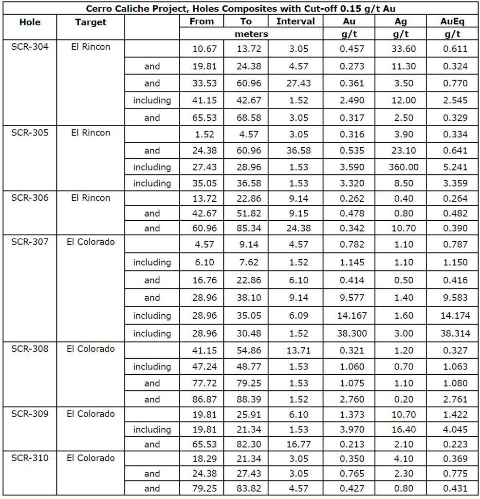
- SCR-305 intercepted 36.5m averaging 0.54 g/t Au; including 1.53m averaging 3.59 g/t Au; including 1.53m averaging 3.32 g/t Au.
- SCR-307 intercepted 9.14m averaging 9.58 g/t Au; including 6.09m averaging 14.17 g/t Au; including 1.52m averaging 38.3 g/t Au.
- SCR-309 intercepted 6.10m averaging 1.37 g/t Au; including 1.53 averaging 3.97 g/t Au.
The map below illustrates the location of the drill holes.
Figure 1: New Drill Holes
The drilling campaign at Cerro Caliche is now complete with final assays expected to be announced in June. New geological data from over 7,200 meters and 63 drill holes will be included in a further updated resource estimate scheduled to be released in the fall of 2022. The updated technical report will also assess the potential economic impact of the new drilling data on the proposed heap leach mining operation.
Mel Herdrick, Sonoro’s VP Exploration, commented, “We continue to report good gold bearing intervals of mineralization as well as higher–grades intercepts that continue to add to potential mineralized material. Results from another 15 drill holes are still pending andwe are working to determine the structural controls of the new higher–grade zones.”
Kenneth MacLeod, Sonoro’s President and CEO, commented, “Our continued success with demonstrating high-grade intercepts at the Colorado zone suggests the potential for an increase in both the grade and size of the gold resource at El Colorado. Additional success at the Rincon zone through infill drilling has also achieved our objective of identifying continuous mineralization between two pit shells located 400meters apart, suggesting the potential for coalescing the pit shells into one larger pit shell.”
John Darch, Sonoro’s Chairman, noted, “The expansion of the El Colorado and El Rincongold mineralized zones, along with the multiple higher-grade intercepts we have announced during the Phase IV drilling program, adds to our optimism that this new geological data may potentially increase both the size and gold grade of the resource.If confirmed, an expanded resource may also improve the project‘spotential economics and extend the mine life of the proposedmining operation.”
El Colorado Gold MineralizedZone
Continued expansion of El Colorado was confirmed with four drill holes completed along the western side of the zone. The shallow, high-grade intercepts of drill hole SCR-307 returned 9.14 meters averaging 9.577 grams of gold per tonne (“g/t Au”) including 6.09 meters averaging 14.167 g/t Au and 1.52 meters averaging 38.3 g/t Au. SCR-307 does not correlate with any known projected vein and may be part of a series of high-grade ore shoots connected to deeper high-grade occurrences in the footwall of the Guadalupe vein structure, believed to be a continuation of El Colorado vein system as discussed in the Company’s News Release dated March 1, 2022.
The Company is also investigating a possible physical connection of SCR-307 to SCR-036 which, as previously announced, intercepted 1.52 meters averaging 11.45 g/t Au. These structures which appear near horizontal in attitude, contain higher gold grades with low silver levels and lead levels exceeding one percent. It is believed that the ore shoots are a repeating series of veins developed in a reverse fault episode which opened horizontal structures in the footwall of the Guadalupe Vein zone allowing higher-grade fluids to deposit gold and lead. Assay results from five holes at El Colorado are pending.
The geology of the El Colorado mineralized zone is complex with a mixture of silicified meta-sedimentary units intruded by a silicified and argillic altered quartz porphyry igneous body and, in deeper parts, granodiorite with dioritic to andesitic dikes. The mineralized structures trending north 10 west and dipping northeasterly cross the zone extending southerly from the Cabeza Blanca quartz veins. As many as five high-grade ore shoots intersect the Guadalupe footwall and the zone contains numerous additional veins and veinlets that are situated apart from the above-described vein zones.
Figure 2: Drill holes at El Colorado
Figure 3: Interpretive Cross Section at El Colorado
El Rincon
Approximately two kilometers north of El Colorado, six drill holes were completed along the northwest trending El Rincon structure between two separate pit shells used to calculate the September 2021 mineral resource estimate. These pit shells are approximately 400 meters apart with continuation of mineralization between the pit shells confirmed by a total of 16 drill holes, over approximately one kilometer of strike length. Drill holes SCR-301 through SCR-306 were infill drilling completed during the current program.
Results from drill holes SCR-301, SRC-302 and SCR-303 were announced on April 21, 2022, and drill holes SCR-304, SCR-305 and SCR-306 are detailed in the table below. Highlights include drill hole SCR-304 which intercepted 1.52 meters averaging 2.49 g/t Au and drill hole SCR-305 which intercepted 36.5 meters, averaging 0.535 g/t Au, including 1.53 meters averaging 3.59 g/t Au and 1.53 meters averaging 3.32 g/t Au.
The structure’s trend is azimuth 310 with dip of 85 northwest to vertical. This vein structure cuts both rhyolitic dikes and sills and bedded meta-sedimentary rocks with gold silver mineralization occurring in both rock types. The El Rincon vein zones are generally parallel to, or along, the rhyolite dike margins.
Figure 4: Drill holes at El Rincon
The following table provides the assay results for the complete list of reported drill holes:
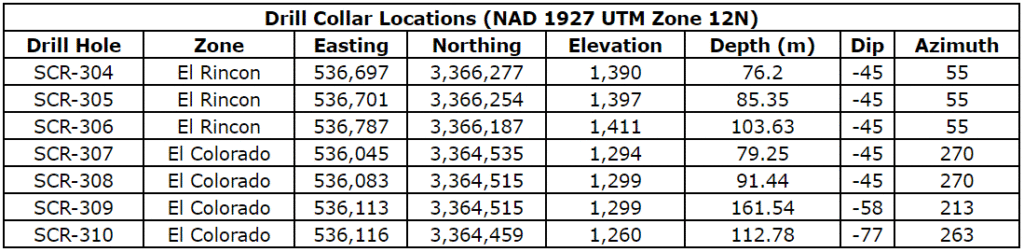
Drill collar locations, azimuths and dips for the drill holes included are provided in the table below.
Quality Assurance/Quality Control (“QA/QC“) Measures and Analytical Procedures
Drill samples are collected with an airstream cyclone and passed into a splitter that divides each sample into quarters. The quartered samples are then bagged and sealed with identification. The sample group has blanks, standards and duplicates inserted into the sample stream.
ALS-Chemex collects the samples and transports them directly to the preparation laboratory in Hermosillo, Sonora. At the laboratory, part of each sample is reduced through crushing, splitting and pulverization from which 200 grams is sent to the ALS-Chemex assay laboratory in Vancouver. Thirty grams undergoes fire assay for gold with the resulting concentrated button of material produced is dissolved in acids and the gold is determined by atomic absorption. Another quantity of the sample is dissolved in four acids for an ICP multi-element analysis.
No QA/QC issues were noted with the results received from the laboratory.
Geologic Description
Cerro Caliche is located 45 kilometers east southeast of Magdalena de Kino in the Cucurpe-Sonora Mega-district of Sonora, Mexico. Multiple historic underground mines were developed in the concession including Cabeza Blanca, Los Cuervos, Japoneses, Las Abejas, Boluditos, El Colorado, Veta de Oro and Espanola. Mineralization types of the Cucurpe-Sonora Mega-district include variants of epithermal low sulfidation veins and related mineralized dikes and associated volcanic domes. Local altered and mineralized felsic dikes cut the mineralized meta-sedimentary rock units and may be associated with mineralization both in the dikes and meta-sedimentary rocks.
Qualified Person Statement
Stephen Kenwood, P.Geo., a Director of Sonoro, is a Qualified Person within the context of National Instrument 43-101 (NI 43-101) and has read and approved this news release. Readers are cautioned that the presence of mineralization on historic mines adjacent to or on Cerro Caliche is not necessarily indicative of economic gold mineralization in the concessions held by the Company.
About Sonoro Gold Corp.
Sonoro Gold Corp. is a publicly listed exploration and development company with a portfolio of exploration-stage precious metal properties in Sonora State, Mexico. The Company has highly experienced operational and management teams with proven track records for the discovery and development of natural resource deposits.
On behalf of the Board of Sonoro Gold Corp.
Per: “Kenneth MacLeod“
Kenneth MacLeod
President & CEO
For further information, please contact:
Sonoro Gold Corp. – Tel: (604) 632-1764
Email: info@sonorogold.com
- Published in Mining, News Home, Sonoro Gold
Usha Resources Closes Second Tranche of Oversubscribed Non-Brokered Private Placement at Premium to Market Price
Usha Resources Ltd. (“USHA” or the “Company”) (TSXV:USHA) (OTCQB:USHAF) (FSE:JO0) is pleased to report that, further to the previously announced non-brokered private placement (see news release dated April 4, 2022) and subject to the approval of the TSX Venture Exchange (the “Exchange“), it has closed the second tranche of a now oversubscribed non-brokered private placement (the “Private Placement“) issuing an aggregate of 2,934,998 units (each a “Unit“) at a price of $0.30 per Unit for total gross proceeds of $880,499. In total, USHA has raised gross proceeds of $1,111,499.40 in both tranches.
“We are very pleased to be able to raise capital at a premium to our share price and we are very grateful for the support from our new and existing shareholders,” stated Deepak Varshney, P.Geo., CEO of the Company.
Each Unit consists of one common share (each a “Share“) of the Company and one transferable common share purchase warrant (each a “Warrant“) with each Warrant exercisable to purchase one Share of the Company at a price of $0.45 per Share for a period of 2 years from the date of closing (the “Expiry Date“).
The Company paid finders’ fees totaling $22,740 cash and 75,800 non-transferable finder warrants (the “Finder Warrants“) to Research Capital Corporation and Richardson Wealth Limited in accordance with applicable securities laws. The Finder’s Warrants are exercisable on the same terms as the Warrants issued in the Private Placement.
All securities issued in the first tranche of the Private Placement are subject to the Exchange hold period, plus a hold period of four months and one day following the closing dates of the Private Placement expiring on September 14, 2022.
The Company also announces that the Exchange has granted the Company an extension to June 13, 2022 to close the final tranche of the Private Placement.
About Usha Resources Ltd.
Usha Resources Ltd. is a North American mineral acquisition and exploration company focused on the development of quality battery and precious metal properties that are drill-ready with high-upside and expansion potential. Based in Vancouver, BC, Usha’s portfolio of strategic properties provides target-rich diversification and consist of Jackpot Lake, a lithium project in Nevada; Nicobat, a nickel‑copper‑cobalt project in Ontario; and Lost Basin, a gold-copper project in Arizona. Usha trades on the TSX Venture Exchange under the symbol USHA, the OTCQB Exchange under the symbol USHAF and the Frankfurt Stock Exchange under the symbol JO0.
USHA RESOURCES LTD.
“Deepak Varshney” CEO and Director
For more information, please call Tyler Muir, Investor Relations, at 1-888-772-2452, email tmuir@usharesources.com, or visit www.usharesources.com.
- Published in News Home, Usha Resources
Usha Resources Announces Creation of Formation Metals Spinout through Signing of Arrangement Agreement
Usha Resources Ltd. (“USHA” or the “Company”) (TSXV:USHA)(OTCQB:USHAF)(FSE:JO0), a North American mineral acquisition and exploration company focused on the development of drill-ready battery and precious metal projects, is pleased to announce unanimous Board of Director approval and support for its previously announced spin-out transaction (the “Spinout”) and that the Company has now entered into an arrangement agreement (the “Arrangement”) with its wholly-owned subsidiary, Formation Metals Corporation (“Formation Metals” or “FMC”), to transfer the Nicobat Nickel-Copper-Cobalt property to FMC.
Under the terms of the Arrangement dated May 10, 2022, USHA shareholders will be issued one (1) share of FMC with respect to every five (5) shares of USHA owned on the share distribution record date (the “Share Distribution Record Date”), which will be predetermined by USHA’s Board of Directors and announced by a news release -in advance. Holders of USHA options and warrants, who exercise their options and/or warrants before the Share Distribution Record Date, will also be entitled to receive one (1) share of FMC with respect to every five (5) shares of USHA.
Upon completion of the Arrangement, USHA shareholders will ultimately own shares in two public companies:
- USHA, which will be focused on its US-based assets, including the Jackpot Lake lithium brine project.
- Formation Metals, which will be focused on nickel at the Nicobat project.
Deepak Varshney, CEO of Usha Resources stated: “Formation Metals was conceived with the idea of expanding our investor base while creating additional shareholder value. This move will provide our investors with an ownership stake in two separate companies, while allowing each entity to pursue separate growth paths and unlock additional opportunities specific to their market. Both USHA and FMC will be better positioned to execute on their respective strategic business plans and have the required flexibility to allocate resources and deploy capital as each see fit. At the end of the day, I want to capitalize on the exciting opportunities we have in motion while building sustainable value for our long-term, big picture shareholders in both USHA and Formation Metals.”
Completion of the Arrangement is subject to a number of conditions, including the following:
- the approval by the shareholders of USHA at a special general meeting (the “Meeting”);
- the approval of the Supreme Court of British Columbia; and
- the acceptance of the Arrangement by the TSX Venture Exchange.
The Arrangement cannot be completed until all the above conditions are met.
A copy of the Arrangement will be posted on www.sedar.com under the profile of the Company. Additional details regarding the Arrangement will be included in the information circular of the Company, which will be mailed to the shareholders of USHA prior to the Meeting.
About the Nicobat Nickel Property
The Nicobat Nickel Property is a nickel-copper-PGE project located in Dobie Township, Northwest Ontario 21 kilometres south of New Gold’s Rainy River Mine which hosts the Zone 34 nickel discovery.
Historic exploration work between 1952 and 1972 included over 15,000 metres of drilling, 220 drill holes and numerous bulk samples that identified a non-compliant historic resource of 5.3 Mt grading 0.24% Ni that contained a high-grade zone of approximately 225,000 tons grading 0.87% Ni.
Recent exploration work includes over 4,000 metres of drilling that has confirmed high-grade nickel-copper shoots do exist and are considerably better than previously recorded in the historical drilling, with drillhole A-04-15 intersecting from surface to approximately 63.75 metres a weighted average of 1.05% nickel and 2.18% copper that included an approximately 9.8-metre interval of 1.92% Ni from 53.95 to 63.75 metres.
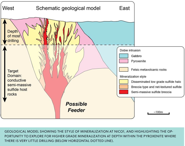
The targeted feeder conduit measures approximately 305 metres by an average of 60 metres in width to a depth of 245 metres that is potentially open at depth and down-plunge to the north and is composed of cumulate textured olivine gabbro. This magma conduit sits in a larger norite body at the base of the Dobie Gabbro. The historical assessment data records high-grade “ribs”, one of which includes the zone described above. Future work will, therefore, focus on making the historic resource compliant current and expanding on the work completed to assess for other high-grade “ribs” and the potential high-grade feeder zone as shown in the model below.
Qualified person
The technical content of this news release has been reviewed and approved by Mr. Andrew Tims, P.Geo., a qualified person as defined by National Instrument 43-101.
About Usha Resources Ltd.
Usha Resources Ltd. is a North American mineral acquisition and exploration company focused on the development of quality battery and precious metal properties that are drill-ready with high-upside and expansion potential. Based in Vancouver, BC, Usha’s portfolio of strategic properties provides target-rich diversification and consist of Jackpot Lake, a lithium project in Nevada; Nicobat, a nickel‑copper‑cobalt project in Ontario; and Lost Basin, a gold-copper project in Arizona. Usha trades on the TSX Venture Exchange under the symbol USHA, the OTCQB Exchange under the symbol USHAF and the Frankfurt Stock Exchange under the symbol JO0.
USHA RESOURCES LTD.
“Deepak Varshney” CEO and Director
For more information, please call Tyler Muir, Investor Relations at (888) 772-2452, email tmuir@usharesources.com, or visit www.usharesources.com.
- Published in News Home, Usha Resources
Canada Silver Cobalt Begins Exploration at its Eby-Otto Gold Property Near Kirkland Lake
The Eby-Otto property is located in a prime geological setting with mineralized veins identified at surface, and is proximal to both the Cadillac-Larder Lake Break and an existing high-grade gold mine.
Coquitlam, BC – TheNewswire – May 10, 2022 – Canada Silver Cobalt Works Inc. (TSXV:CCW) (OTC:CCWOF) (Frankfurt: 4T9B) (the “Company” or “Canada Silver Cobalt”) announces that it has recently completed a drone magnetic geophysical survey and has entered Phase 1 of its 2022 exploration plan for the Eby-Otto gold property near the town of Kirkland Lake.
The Company has outlined the planned three exploration phases at the property as follows:
Phase 1: The first phase will consist of an initial site assessment to determine the logistics of future operations and will provide the Company time to receive any pending surface exploration work permits that will be necessary. Surveying will be completed for key Standard Iron Bars (SIB), legacy claim posts, and access points to refresh select existing cut line grids. An overall geological assessment will be completed based on field work consisting of geological mapping, stripping key outcrops, and possibly further MMI geochemical or targeted and detailed ground geophysics if the technical team deems it necessary.
As part of Phase 1, the Company has recently concluded a drone magnetic survey on the entire claim package conducted by EarthEx Geophysical Solutions Inc. The DroneMag system they use provides an extremely high-resolution end-product and uses a proprietary automatic obstacle avoidance system which provides a smooth flight path to drape over taller trees and avoid obstacles. This allows the drone to fly as low as possible to achieve the highest possible resolution. It uses a proprietary navigation system that allows for longer range RTK (real-time kinematic) controlled autonomy which results in high quality, clean magnetic imagery. The survey was completed at a 25m line spacing which should allow for smaller structures, such as vein systems, to be resolved and visible.
Phase 2: The second phase of exploration will be based on the results from Phase 1 and will expand to include diamond drilling to intercept specific regional structures based on the initial geophysical data provided by the drone magnetic survey, historic geological data, regional geophysics, geological mapping, and existing electromagnetic (EM) surveys completed by geologist Doug Robinson prior to the Company’s acquisition of the property.
Phase 3: The third phase of exploration will expand on the drilling and field work outlined in Phase 2. Once the 3D inversion of the drone mag survey is received and the data has been interpreted, the technical team will correlate this data with known mineralization that has been identified via field work to better refine the targets, and adjust the exploration accordingly.
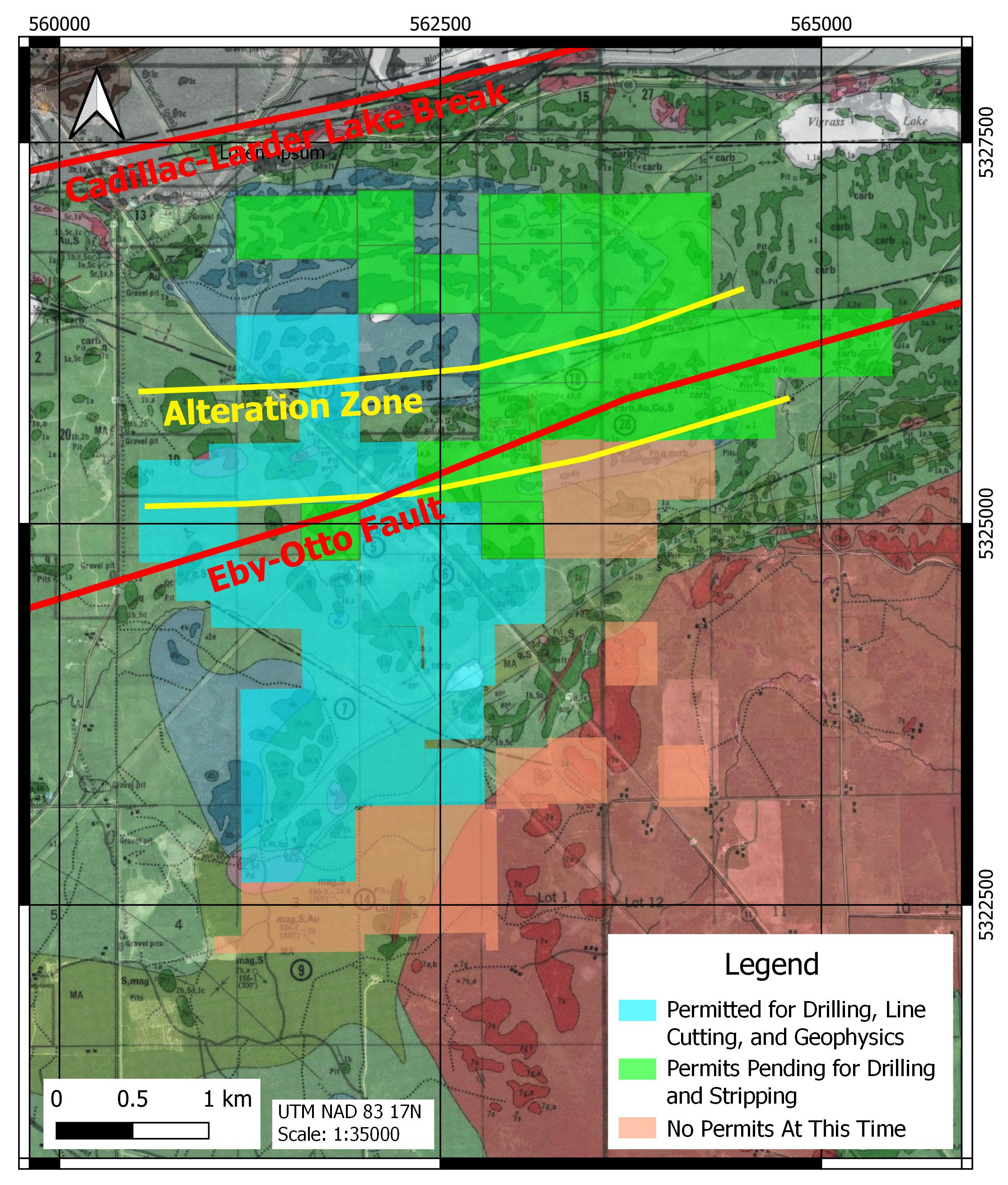
The Company now has option agreements on contiguous properties covering 1,000 ha at Eby-Otto and the area, importantly, includes approximately 5km of strike length along the Eby-Otto Fault and along a major alteration trend (OGS OFR 6184). The property is within the Kirkland Lake gold district in northeastern Ontario and is located within 5km of Agnico-Eagle’s producing, high-grade Macassa Gold Mine.
Matthew Halliday, P.Geo., President of Canada Silver Cobalt Works, states, “Our geological team is excited to get boots on the ground at Eby-Otto. It is a very promising land package close to a producing mine with outcropping mineralized veins already identified. With the recent drone-borne magnetic survey just completed, we will assimilate this information with known data and put our existing and pending exploration permits to use. We believe having a highly prospective precious metals play underway will be conducive in the current market to adding value for shareholders.”
Click Image To View Full Size
Figure 1: Location of property showing the overall claim package and locations of existing and pending drill permits.
Qualified person
The technical information in this news release was prepared under the supervision of Mr. Matthew Halliday, P.Geo., (PGO), President, COO and VP Exploration of Canada Silver Cobalt Works Inc., a qualified person in accordance with National Instrument 43-101.
About Canada Silver Cobalt Works Inc.
Canada Silver Cobalt Works Inc. recently discovered a major high-grade silver vein system at Castle East located 1.5 km from its 100%-owned, past-producing Castle Mine near Gowganda in the prolific and world-class silver-cobalt mining district of Northern Ontario. The Company has completed a 60,000m drill program aimed at expanding the size of the deposit with an update to the resource estimate underway.
In May 2020, based on a small initial drill program, the Company published the region’s first 43-101 resource estimate that contained a total of 7.56 million ounces of silver in Inferred resources, comprising very high-grade silver (8,582 grams per tonne un-cut or 250.2 oz/ton) in 27,400 tonnes of material from two sections (1A and 1B) of the Castle East Robinson Zone, beginning at a vertical depth of approximately 400 meters. Note that mineral resources that are not mineral reserves do not have demonstrated economic viability. Please refer to Canada Silver Cobalt Works Press Release May 28, 2020, for the resource estimate. Report reference: Rachidi, M. 2020, NI 43-101 Technical Report Mineral Resource Estimate for Castle East, Robinson Zone, Ontario, Canada, with an effective date of May 28, 2020, and a signature date of July 13, 2020.
The Company also has: (1) 14 battery metals properties in Northern Quebec where it has recently completed a nearly 10,000-metre drill program on the Graal property; and (2) the prospective 1,000-hectare Eby-Otto gold property close to Agnico Eagle’s high-grade Macassa Mine near Kirkland Lake, Ontario where it will be exploring in 2022.
Canada Silver Cobalt’s flagship silver-cobalt Castle mine and 78 sq. km Castle Property feature strong exploration upside for silver, cobalt, nickel, gold, and copper. With underground access at the fully owned Castle Mine, an exceptional high-grade silver discovery at Castle East, a pilot plant to produce cobalt-rich gravity concentrates, a processing facility (TTL Laboratories) in the town of Cobalt, and a proprietary hydrometallurgical process known as Re-2Ox (for the creation of technical-grade cobalt sulphate as well as nickel-manganese-cobalt (NMC) formulations), Canada Silver Cobalt is strategically positioned to become a Canadian leader in the silver-cobalt space. More information at www.canadasilvercobaltworks.com
“Frank J. Basa”
Frank J. Basa, P. Eng.
Chief Executive Officer
For further information, contact:
Frank J. Basa, P.Eng.
Chief Executive Officer
416-625-2342
- Published in Canada Cobalt Works, News Home
Granada Gold Assays 4.33 G/T Gold from 500-Tonne Surface Bulk Sample
Rouyn Noranda, Quebec, Granada Gold Mine Inc. (TSXV:GGM) (the “Company” or “Granada”) is pleased to provide a gold assay of 4.33 grams per tonne on its 500-tonne bulk sample taken from surface in 2020.
HIGHLIGHTS:
- A 500-tonne mineralized, and 900-tonne waste rock bulk sample were taken from surface in 2020
- A 10.5-tonne composite sample was screened from the 500-tonne mineralized bulk sample
- The 10.5-tonne composite sample was crushed, ground and screened at 20 mesh to ensure no visible gold was in the sample to be evaluated.
Frank J. Basa, P.Eng., President and CEO notes, “The bulk sample confirms both near-surface drill results and the potential for a higher-grade open pit mining scenario. Higher grades translate to lower processing costs per ounce and lower capital expenditures for a processing plant. The bulk sample has returned a higher gold grade than the current target open pit grade of 2 g/t.”
The 500-tonne bulk sample was taken 400 meters east of Pit #1 on the Vein 1 structure which trends 5.2 kilometers east-west. Historically Vein 1 was mined from underground in the thirties at 9-10 grams per tonne gold, and mined by open pit in 1993-94 at 5.17 grams per tonne gold having mined 87,000 tonnes and again in 1996 at 3.46 grams per tonne gold having mined 22,095 tonnes.
BULK SAMPLE ASSAY RESULTS
The screened, minus 20 mesh material was passed through the sampling tower at Temiskaming Testing Laboratory (TTL) in Cobalt, Ontario. Five super sacs were sampled by taking four samples from each super sac for assaying. Duplicate assays were run on one sample per super sac. The table below identifies the sample assay results. No visible gold was recovered when processing the minus 20 mesh portion of the bulk sample. Visible gold was present in the plus 20 mesh material. At this stage of evaluating the surface mineralization sample, the company is assessing the grade of the material without any high-grade visible gold. It has been estimated, based on metallurgical testing, that close to 50 percent of the gold at Granada is in native form (43-101 Technical Report Updated Mineral Resource Estimate, March 15, 2021).
Table 1. Bulk Sample Assay Results for minus 20 mesh fraction
| Sample ID | Sample Source | Au by AA (g/t) |
| OSLSR007-1 | Bag #006-1 | 5.176 |
| OSLSR007-1DUP | 4.795 | |
| OSLSR007-2 | 3.949 | |
| OSLSR007-3 | 4.562 | |
| OSLSR007-4 | 2.558 | |
| OSLSR007-5 | Bag #006A-1 | 10.197 |
| OSLSR007-5DUP | 9.052 | |
| OSLSR007-6 | 13.003 | |
| OSLSR007-7 | 9.693 | |
| OSLSR007-8 | 3.621 | |
| OSLSR007-9 | Bag #007-1 | 4.199 |
| OSLSR007-10 | 2.858 | |
| OSLSR007-11 | 3.249 | |
| OSLSR007-12 | 2.294 | |
| OSLSR007-13 | Bag #008-1 | 3.210 |
| OSLSR007-13DUP | 3.063 | |
| OSLSR007-14 | 2.850 | |
| OSLSR007-15 | 2.661 | |
| OSLSR007-16 | 3.397 | |
| OSLSR007-17 | Bag #009-1 | 1.246 |
| OSLSR007-18 | 1.352 | |
| OSLSR007-19 | 1.341 | |
| OSLSR007-20 | 1.237 |
BULK SAMPLE LOCATION
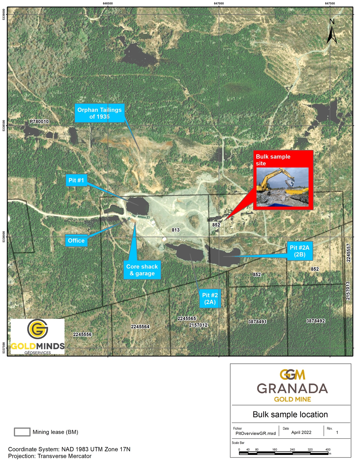
Click Image To View Full Size
Qualified person
The technical information in this news release has been reviewed by Frank J. Basa, P.Eng., m ember of Ontario Order of Engineers and a qualified person in accordance with National Instrument 43- 101 standards.
Quality Control and Reporting Protocols
The subsamples and duplicates were processed at TTL. The sample weights were 1 Kg. Each sample was split, and 500 grams were pulverized to -200 mesh, a 30-gram split was used in the fire assay process with AA finish. The process includes blanks and standards which are in line with the expected results which allow public disclosure of the results. Quality Assurance/Quality Control (“QA/QC”) and interpretation of results is performed by qualified persons employing a QA/QC program consistent with NI 43-101 and industry best practices. Standards and blanks are included with every 20 samples for QA/QC purposes for this program in addition to the lab QA/QC.
Location
The Granada Gold project is located in an established mining district 5 km south of Rouyn-Noranda adjacent to the prolific Cadillac Break shear zone, which is hosted in Pontiac metasedimentary rocks, granites, and younger syenite sills along the Granada shear zone (LONG Bars Zone). The project is located on the same side of the Cadillac Fault as the Canadian Malartic mine property, which has historically produced 12.7 million ounces of gold from 1935 to 2010 with an additional 5 million ounces as of June 18, 2020 (Canadian Malartic Technical Report of March 25, 2021 & Le Citoyen June 19, 2020).
About Granada Gold Mine Inc.
Granada Gold Mine Inc. continues to develop and explore its 100% owned Granada Gold Property near Rouyn-Noranda, Quebec, and is adjacent to the prolific Cadillac Break. The Company owns 14.73 square kilometers of land in a combination of mining leases and claims. The company is currently undergoing a large drill program with 30,000m out of 120,000m complete. The drills are currently paused to provide the technical team with the necessary time to evaluate and assimilate existing data.
The Granada Shear Zone and the South Shear Zone contain, based on historical detailed mapping as well as from current and historical drilling, up to twenty-two mineralized structures trending east-west over five and a half kilometers. Three of these structures were mined historically from four shafts and three open pits. Historical underground grades were 8 to 10 grams per tonne gold from two shafts down to 236 m and 498 m with open pit grades from 3.5 to 5 grams per tonne gold.
The property includes the former Granada Gold underground mine which produced more than 50,000 ounces of gold at 10 grams per tonne gold in the 1930’s from two shafts before a fire destroyed the surface buildings. In the 1990’s, Granada Resources extracted a bulk sample (Pit #1) of 87,311 tonnes grading 5.17 g/t Au. They also extracted a bulk sample (Pit # 2) of 22,095 tonnes grading 3.46 g/t Au.
On March 15, 2021, the Company released an updated NI 43-101 resource estimate for the Granada Gold project (Please see January 29, 2021 news release) with a combined total of 713,000 gold ounces of measured, indicated, and inferred. This estimate contains 351,000 gold ounces of combined measured, indicated, and inferred for the open pit and 362,000 gold ounces of combined measured, indicated, and inferred for the underground. Please see Table 2 below for full details. Report reference: Granada Gold Project Mineral Resource Estimate Update, Rouyn-Noranda, Quebec, Canada authored by Yann Camus, P.Eng. and Maxime Dupere, B.Sc, P.Geo., SGS Canada Inc. with an effective date of December 15, 2020, and signature date of March 15, 2021.
Table 2: Mineral Resource Estimate Showing Tonnes, Average Grade, and Gold Ounces
| Type | Category | Tonnes | Avg Grade Au (g/t) | Gold Ounces |
| Open Pit | Measured | 3,756,000 | 1.89 | 228,000 |
| Indicated | 1,357,000 | 2.55 | 111,000 | |
| Measured + Indicated | 5,113,000 | 2.06 | 339,000 | |
| Inferred | 34,000 | 11.29 | 12,000 | |
| Underground | Measured | 37,000 | 4.22 | 5,000 |
| Indicated | 807,000 | 4.02 | 104,000 | |
| Measured + Indicated | 844,000 | 4.03 | 109,000 | |
| Inferred | 1,244,000 | 6.33 | 253,000 |
The Granada Shear Zone and the South Shear Zone contain, based on historical detailed mapping as well as from current and historical drilling, up to twenty-two mineralized structures trending east-west over five and half kilometers. Three of these structures were mined historically from two shafts and two open pits. Historical underground grades were 8 to 10 grams per tonne gold from two shafts down to 236 m and 498 m with open pit grades from 5 to 3.5 grams per tonne gold.
The Company is in possession of all mining permits required to commence the initial mining phase, known as the “Rolling Start”, which allows the company to mine up to 550 tonnes per day. Additional information is available at www.granadagoldmine.com .
“Frank J. Basa”
Frank J. Basa P. Eng.
President and Chief Executive Officer
For further information, please contact:
Frank J. Basa, P. Eng., President and CEO at 1-819-797-4144 or
Wayne Cheveldayoff, Corporate Communications, at 416-710-2410 or waynecheveldayoff@gmail.com
- Published in Granada Gold Mine, News Home
SONORO SUBMITS FEDERAL ENVIRONMENTAL PERMIT APPLICATION FOR CERRO CALICHE
Sonoro Gold Corp. (TSXV: SGO | OTCQB: SMOFF | FRA: 23SP) (“Sonoro” or the “Company”) is pleased to announce it has filed an Environmental Impact Statement, or Manifestacion de Impacto Ambiental (“MIA”) for its Cerro Caliche gold project in Sonora, Mexico. Under Mexican law, mining construction and operation activities require an approved MIA, as well as a Change of Land Use permit, or Autorizacion en Cambio de Uso de Suelo (“ETJ”), from the Mexican federal permitting authority, Secretaria de Medio Ambiente y Recursos Naturales (“SEMARNAT”). The Company is currently completing the required documentation for the Change of Land Use application and anticipates filing with SEMARNAT in the near future.
“Completing the MIA provided us with an opportunity to work closely with various stakeholders and I would like to thank everyone who worked alongside us as we conducted multiple environmental baseline studies and socio-economic assessments,” stated VP of Operations, Jorge Diaz. “The filing of the MIA is an important step in the project’s development and we will continue to move the project forward during the permitting process.”
Kenneth MacLeod, Sonoro’s President and CEO commented, “The filing of the MIA follows the compilation of extensive technical and environmental studies conducted on the Cerro Caliche concession over the past four years and supports the Company’s objective to develop Sonoro’s proposed heap leach mining operation.“
John Darch, Sonoro’s Chairman added, “We are delighted to report to our shareholders the filing of the Environmental Impact Statement, as it is a key milestone in the development of our proposed heap leach mining operation.”
The scope of the MIA includes open pits, waste dumps, crushing facilities, heap leach pad, leach solution ponds, gold recovery facilities, haul roads, building structures and infrastructure, as proposed in the Company’s Preliminary Economic Assessment dated October 29, 2021. The document also provides flexibility for the continual optimization of the mine plan to support operational growth and resource expansion.
During the MIA-ETJ permitting phase, the Company will continue to move the project forward as it initiates site preparation work and focuses on arranging project financing. Management will also update the project’s estimated resource to incorporate the results from its nearly completed Phase IV drilling program and assess the potential impact on the project’s mine life and economic viability.
About Sonoro Gold Corp.
Sonoro Gold Corp. is a publicly listed exploration and development Company holding the near-development-stage Cerro Caliche project and the exploration-stage San Marcial project in Sonora State, Mexico. The Company has highly experienced operational and management teams with proven track records for the discovery and development of natural resource deposits.
On behalf of the Board of SONORO GOLD CORP.
Per: “Kenneth MacLeod“
Kenneth MacLeod
President & CEO
For further information, please contact:
Sonoro Gold Corp. – Tel: (604) 632-1764
Email: info@sonorogold.com
- Published in Mining, News Home, Sonoro Gold
Usha Resources Begins Trading on the Frankfurt Stock Exchange as FSE:JO0
Usha Resources Ltd. (“USHA” or the “Company”) (TSXV:USHA) (OTCQB:USHAF) (FSE:JO0), a North American mineral acquisition and exploration company focused on the development of drill-ready battery and precious metal projects, is pleased to announce the listing of its common shares for trading on the Frankfurt Stock Exchange (“FSE”) under the symbol “JO0” with ISIN CA91734F1080 and WKN A3DK8K.
“With the recent acquisition of the Jackpot Lake Lithium Project, three planned drill programs and mounting investor interest in our Nicobat Nickel Project spin out, it makes sense to broaden USHA’s visibility and connect with a larger, global community of potential European institutional and retail investors,” commented Deepak Varshney, CEO of Usha Resources. “Anytime we can make it easier and help facilitate investment in the Company by the European investment community. we’ll take action so that all shareholders benefit.”
The Frankfurt Stock Exchange is the world’s third-largest organized trading market in terms of turnover and dealing in securities behind the New York Stock Exchange and NASDAQ. The listing of the Company’s shares on the FSE marks another step torward creating greater liquidity and increasing shareholder and overall market awareness for USHA’s drill-ready projects. The Company’s common shares are now cross-listed on the TSX Venture Exchange, OTCQB® and the FSE.
The Jackpot Lake Lithium Project
The Jackpot Lake Lithium Project (“the Property) is located within Clark County, 35 kilometres northeast of Las Vegas, Nevada, and is comprised of 140 mineral claims that total 2,800 acres. The project is exploring a “playa” which appears to be within a closed basin that may contain potentially lithium-rich brines. The geologic model is similar to that of Albemarle’s Silver Peak Nevada Lithium Mine which has operated continuously since 1966, and Iconic Mineral’s Bonnie Claire Project, which recently released a Preliminary Economic Assessment report (PEA) that indicates 40-year mine with an after-tax NPV8% of 1.5 billion, where sediments from lithium‑rich surrounding source rocks accumulate and fill the deposit leading to a potential concentration of lithium brine due to successive evaporation and concentration events.
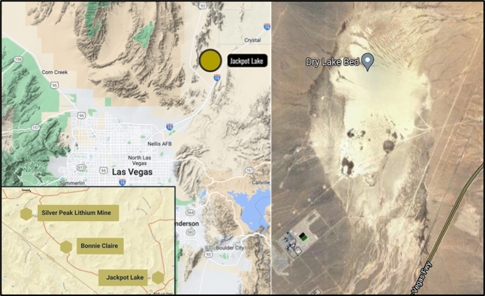
Figure 1 – Left, location of Jackpot Lake. Right, aerial image of the “playa.”
The project is considered to be “drill-ready” based on the following work which has successfully delineated a 5 x 2 kilometre anomaly within a closed basin that suggests the presence of a highly concentrated brine:
- 129 core samples collected by the USGS with an average lithium value of 175 ppm with a high of 550 ppm and spectrographic and atomic-absorption analyses of 135 stream sediment samples confirming the potential for lithium mineral deposits.
- Gravitational surveying which has identified a closed basin, critical for ensuring brines remain within the basin without dilution from external water sources.
- Geophysical modelling based upon gravitational and controlled source audio magnetotellurics/magnetotellurics (CSAMT/MT) surveys has provided evidence of highly concentrated brines which are relatively near the surface. The CSAMT survey results of the Jackpot Lake Project demonstrate a large consistent body of very low resistivity – consistent with highly concentrated brine behavior – throughout the property, predominantly above bedrock depths of 625 meters.
The CSAMT Survey and report was conducted and prepared by Hasbrouck Geophysics, who has extensive experience of both surveying and data processing for brine-bearing basin environments across the Southwestern United States.
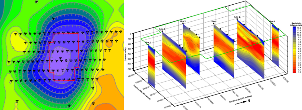
Figure 2- Left, gravitational surveying outlined the footprint of the Jackpot lithium brine anomaly. Right, CSMAT survey slices showing a cross-section of the anomaly illustrating the highly enriched brines throughout the property in red.
Based on the above, the Company intends on completing an aggressive exploration program by drilling both shallow and deep holes to test the targets outlined by the CSAMT Survey at possible higher concentration brine zones with the goal of completing a 43-101 resource estimate by Q4 of 2022.
Qualified Person
The technical content of this news release has been reviewed and approved by Mr. Helgi Sigurgeirson, P.Geo., a qualified person as defined by National Instrument 43-101 Standards of Disclosure for Mineral Projects (“NI 43-101”).
About Usha Resources Ltd.
Usha Resources Ltd. is a North American mineral acquisition and exploration company focused on the development of quality battery and precious metal properties that are drill-ready with high-upside and expansion potential. Based in Vancouver, BC, Usha’s portfolio of strategic properties provides target-rich diversification and consist of Jackpot Lake, a lithium project in Nevada; Nicobat, a nickel‑copper‑cobalt project in Ontario; and Lost Basin, a gold-copper project in Arizona. Usha trades on the TSX Venture Exchange under the symbol USHA, the OTCQB Exchange under the symbol USHAF and the Frankfurt Stock Exchange under the symbol JO0.
We seek Safe Harbor.
USHA RESOURCES LTD.
“Deepak Varshney” CEO and Director
For more information, please phone Tyler Muir, Investor Relations at 1 (888) 772-2452, email tmuir@usharesources.com, or visit www.usharesources.com.
- Published in Mining, News Home, Usha Resources
Usha Resources Announces TSXV Approval to Jackpot Lake Acquisition
Usha Resources Ltd. (“USHA” or the “Company”) (TSXV:USHA)(OTCQB:USHAF), a North American mineral acquisition and exploration company focused on the development of drill-ready battery and precious metal projects, is pleased to announce that further to its news releases dated March 31, 2022 and April 25, 2022, it has received the final approval from the TSX Venture Exchange (the “Exchange”) to its mineral property option agreement dated March 17, 2022, as amended, entered into with Ares Strategic Mining Inc. (the “Vendor”) to acquire a 100% interest in 140 mineral claims located in Jackpot Lake, Clark County, Nevada (the “Property”).
The Company is proceeding with the first issuance of 1,678,062 common shares (the “Shares”) to the Vendor at a deemed price of $0.30 per Share, which price is based on the Company’s 10-day VWAP. The Shares are subject to the Exchange hold period plus a hold period of four months and one day.
Deepak Varshney, CEO of Usha Resources, stated, “The closing of this acquisition is a key transformative event that firmly establishes the Company as a North American battery metals explorer. We are very excited to move this project forward and plan on completing an aggressive exploration program by drilling both shallow and deep holes with the goal of completing a 43-101 resource estimate by Q4 of 2022. The addition of Jackpot means that 2022 will be an extremely active period for USHA with three planned drill programs and a spinout giving our shareholders a number of potential catalysts across our various projects.”
The Property
The Property is located within Clark County, 35 kilometres northeast of Las Vegas, Nevada, and is comprised of 140 mineral claims that total 2,800 acres. The project is exploring a “playa” which appears to be within a closed basin that may contain potentially lithium-rich brines. The geologic model is similar to that of Albemarle’s Silver Peak Nevada Lithium Mine which has operated continuously since 1966, and Iconic Mineral’s Bonnie Claire Project, which recently released a Preliminary Economic Assessment report (PEA) that indicates 40-year mine with an after-tax NPV8% of 1.5 billion, where sediments from lithium‑rich surrounding source rocks accumulate and fill the deposit leading to a potential concentration of lithium brine due to successive evaporation and concentration events.
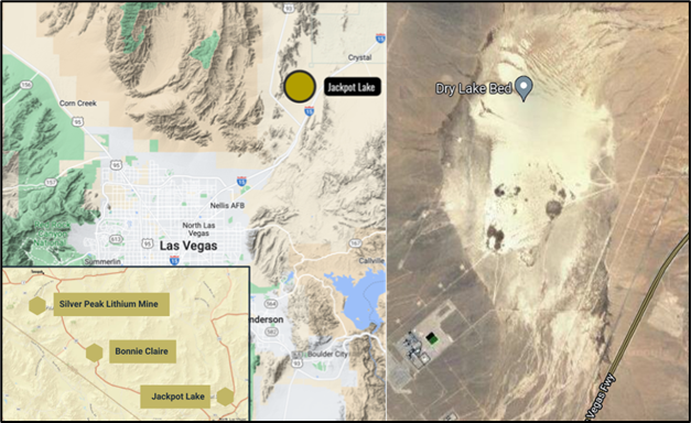
Figure 1 – Left, location of Jackpot Lake. Right, aerial image of the “playa”.
The project is considered to be “drill-ready” based on the following work which has successfully delineated a 5 x 2 kilometre anomaly within a closed basin that suggests the presence of a highly concentrated brine:
- 129 core samples collected by the USGS with an average lithium value of 175 ppm with a high of 550 ppm and spectrographic and atomic-absorption analyses of 135 stream sediment samples confirming the potential for lithium mineral deposits.
- Gravitational surveying which has identified a closed basin, critical for ensuring brines remain within the basin without dilution from external water sources.
- Geophysical modelling based upon gravitational and controlled source audio magnetotellurics/magnetotellurics (CSAMT/MT) surveys has provided evidence of highly concentrated brines which are relatively near the surface. The CSAMT survey results of the Jackpot Lake Project demonstrate a large consistent body of very low resistivity – consistent with highly concentrated brine behavior – throughout the property, predominantly above bedrock depths of 625 meters.
The CSAMT Survey and report was conducted and prepared by Hasbrouck Geophysics, who has extensive experience of both surveying and data processing for brine-bearing basin environments across the southwestern U.S.
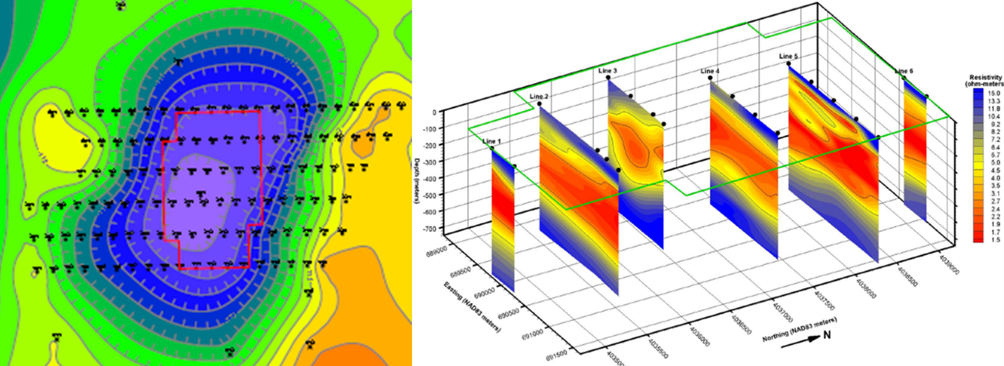
Figure 2- Left, gravitational surveying outlined the footprint of the Jackpot lithium brine anomaly. Right, CSMAT survey slices showing a cross-section of the anomaly illustrating the highly enriched brines throughout the property in red.
Based on the above, the Company intends on completing an aggressive exploration program by drilling both shallow and deep holes to test the targets outlined by the CSAMT Survey at possible higher concentration brine zones with the goal of completing a 43-101 resource estimate by Q4 of 2022.
Qualified Person
The technical content of this news release has been reviewed and approved by Mr. Helgi Sigurgeirson, P.Geo., a qualified person as defined by National Instrument 43-101 Standards of Disclosure for Mineral Projects (“NI 43-101”).
About Usha Resources Ltd.
Usha Resources Ltd. is a North American mineral acquisition and exploration company focused on the development of quality battery and precious metal properties that are drill-ready with high-upside and expansion potential. Based in Vancouver, BC, Usha’s portfolio of strategic properties provides target-rich diversification and consist of Jackpot Lake, a lithium project in Nevada; Nicobat, a nickel‑copper‑cobalt project in Ontario; and Lost Basin, a gold-copper project in Arizona. Usha trades on the TSX Venture Exchange under the symbol USHA and the OTCQB Exchange under the symbol USHAF.
We seek Safe Harbor.
USHA RESOURCES LTD.
“Deepak Varshney” CEO and Director
For more information, please phone Tyler Muir, Investor Relations at 1 (888) 772-2452, email tmuir@usharesources.com, or visit www.usharesources.com.
- Published in News Home, Usha Resources