SONORO GOLD COMPLETES PHASE IV DRILLING PROGRAM AT CERRO CALICHE REPORTS MULTIPLE HIGHER-GRADE INTERCEPTS & EXPANSION OF GOLD MINERALIZED ZONES
Sonoro Gold Corp. (TSXV: SGO | OTCQB: SMOFF | FRA: 23SP) (“Sonoro” or the “Company”) is pleased to report assay results from the final seven drill holes, completing the Phase IV drilling program at its Cerro Caliche gold project in Sonora, Mexico. In total, the Company completed over 7,200 meters of reverse circulation drilling with 63 drill holes which returned multiple higher-grade gold intercepts and demonstrated the expansion of several known mineralized gold zones within the Cerro Caliche concession.
The objective of the program was to increase the estimated size and grade of the project’s oxide gold mineralization, as well as to extend the estimated life of a proposed heap leach mining operation as outlined in the Preliminary Economic Assessment (“PEA”) and updated Mineral Resource Estimate filed under the Company’s profile on SEDAR on October 29, 2021.
On May 9, 2022, the Company announced positive results of an updated PEA based on an optimized mine plan to potentially increase the project’s previously reported economic parameters. The updated report was based on the same mineral resource estimate contained in the Company’s initial PEA and did not include the new geological data from the Phase IV campaign.
Drilling results from the now completed Phase IV campaign will be included in an updated resource estimation scheduled to be announced in the fall of 2022. The economic impact of the updated resource on the proposed heap leach mining operation is also to be assessed and will be contemplated in a further technical report.
Mel Herdrick, Sonoro’s VP Exploration, commented, “Phase four has been a successful drilling campaign with continued reporting of mineralized extensions and higher-grade intercepts.As the project continues to move through the current permitting phase, the objective of the exploration team now is to refine our understanding of the new extensions and higher-grade zones, as well as the potential impact of the new drilling data on the project’s resource.”
Kenneth MacLeod, Sonoro’s President and CEO, added, “The completion of the drilling program is another important milestone in the development of Cerro Caliche. Last month we announced the positive results of an updated PEA and are currently assessing the potential economic impact of the new drilling data on the proposed heap leach mining operation. An updated resource estimation is expected to be filed this fall and we will continue to work on securing project financing and moving the project forward.”
John Darch, Sonoro’s Chairman, noted, “With regards to the successful completion of the drilling program, the Board would like to specifically commend the efforts of our exploration team in Mexico, most notably VP of Exploration Mel Herdrick, VP of Operations Jorge Diaz and Chief Geologist Oscar Gonzalez.These individuals have been instrumental in the success of Cerro Caliche’s exploration and development programs.”
Final Drilling Results
The results announced in this news release reflect drilling activity conducted at the Abejas gold mineralized zone located at the eastern perimeter of the Central Pit Zone, with the reported intercepts situated outside of the pit shell used to calculate the mineral resource estimate in the initial PEA.
Highlights are as follows:
- SCR-321 intercepted 15.24m averaging 1.336 g/t Au; including 4.57m averaging 3.657 g/t Au;
- SCR-322 intercepted 18.29m averaging 0.785 g/t Au; including 1.52m averaging 4.88 g/t Au.
The map below illustrates the location of the drill holes.
Figure 1: Drill holes at Abejas
AbejasMineralizedZone
The Abejas zone is in the most eastern part of the property’s main body of gold mineralization where seven drill holes demonstrated an approximate 30-meter southernly extension outside of the estimated resource pit shell. Three of the seven drill holes also returned higher-grade intercepts, including drill hole SCR-321 which intercepted 15.24 meters averaging 1.336 grams of gold per tonne (“g/t Au”), including 4.57 meters averaging 3.657 g/t Au and drill hole SCR-322 which intercepted 18.29 meters averaging 0.785 g/t Au, including 1.52 meters averaging 4.880 g/t Au.
The Abejas extension is terminated by a northeasterly trending fault that continues southwesterly to offset the Los Cuervos mineralization. Further detailed work around the faulted Abejas zone could determine the same relationship with possible additional targets.
Both drill holes SCR-321 and SCR-322 correlate with other plotted vein projections intersected further north and the geology of the Abejas zone is similar to the Japoneses gold mineralized zone with most rock drilled being Jurassic-Cretaceous metasedimentary quartzite, shale and local limestone beds. Structures with quartz vein fillings cross with the normal northwest orientation and are part of the wider zone of sheeted gold mineralized veins.
The Abejas zone is about 600 meters long and is traced further northwesterly to join the Veta del Oro zone which has a long, well-defined vein zone with higher gold and silver grades. Anomalous silver content is also present in the results with 24.9 grams per tonne intercepted in drill-hole SCR-321 between depths of 9.14 and 10.67 meters. Lead is also anomalous with gold but in broader anomalies. Silicification is common in the area, especially close to the vein zones.
The table below provides the assay results for the complete list of reported drill holes. Vein intersections appear to be near true widths reported from assay intervals. Drill holes cross the veins with 45-degree inclination, while veins appear to have dips around 50 to 60 degrees.
Drill collar locations, azimuths and dips for the drill holes included are provided in the table below.

Phase IV Drilling Program
In November 2021, the Company announced it had resumed drilling with the objective of increasing the estimated size and grade of the project’s oxide gold mineralization. An independent PEA completed on the Cerro Caliche project demonstrated a potentially viable seven-year open pit, heap leach mining operation with a production capacity of up to 15,000 tonnes per day. An increase in the size and grade of the project’s resource may not only extend the life of the proposed operation but may also improve the overall economics of the project.
The Phase IV drilling program was designed to potentially expand known mineralized zones, including zones excluded from the mineral resource estimate due to lack of required drilling density. The program also drilled potential higher-grade targets identified by a surface sampling program completed in the summer of 2021.
The map below illustrates the location of drill holes completed during the Phase IV drilling program.
Figure 2: Drill holes at Cerro Caliche
El ColoradoMineralized Gold Zone
Drilling completed at El Colorado provided the Company with an improved structural understanding of the complexity of the mineralized zone, including higher-grade blind (lack of surface exposure) structures or shoots. While the zone is complexly faulted and veined, the additional drill holes completed during the Phase IV program began to reveal coherent high-grade gold bearing veins, as well as anastomosing veins diverging and branching from zone’s main veins.
Collectively, these suggest an increased potential for a higher-grade open pit which, if confirmed, may also potentially increase the average gold content of the entire mineralized zone.
As previously announced, drilling completed at El Colorado returned multiple higher-grade gold intercepts within larger intervals of high-grade gold mineralization including drill hole SCR-286 which intercepted high-grade gold mineralization at the deepest level of El Colorado’s epithermal system drilled to date.
Near the bottom of the hole, a 27.43-meter intercept averaged 5.36 g/t Au, including 4.57 meters averaging 7.16 g/t Au, and 4.57 meters of 22.09 g/t Au, including 1.53 meters averaging 46.5 g/t Au and 1.52 meters averaging 3.25 g/t Au.
Figure 3: Interpretive Cross Section at El Colorado
A total of 20 additional drill holes were completed outside of the estimated resource pit shell used to calculate the zone’s gold resource. As previously announced, five drill holes demonstrated an expansion of approximately 30 meters along the northwestern side of the estimated resource pit shell.
Oxidized mineralized material is present throughout El Colorado with no significant sulfide minerals present. The geology is a mixture of silicified meta-sedimentary units intruded by a silicified and argillic altered quartz porphyry igneous body and, in deeper parts, granodiorite with dioritic to andesitic dikes. The mineralized structures trending north 10 west and dipping northeasterly cross the zone extending southerly from the Cabeza Blanca quartz veins.
Guadalupe Mineralized Gold Zone
Located to the north of El Colorado, and parallel to the Cabeza Blanca mineralized gold zone, Guadalupe was excluded from the updated mineral resource estimate due to its lack of sufficient drilling density.
Drilling completed at Guadalupe during Phase IV returned intercepts of higher-grade gold vein material at depth, including previously announced drill hole SCR-280 which intercepted 3.05 meters averaging 19.56 g/t Au, including 1.53 meters averaging 37.90 g/t Au. The higher-grade zone’s repetitive character likely is due to a higher degree of shearing at the footwall of the Guadalupe vein structure.
Figure 4: Drill holes at El Rincon
The footwall shows stronger shear character, including mylonitic vein textures locally, and suggests the potential for development and further exploration in areas to the west where numerous veins are present. Guadalupe’s entire structural zone may be permissive over more than 100 meters width.
Buena Suerte Mineralized Gold Zone
Buena Suerte is approximately 300 meters east of El Colorado and drilling completed during Phase IV extended the Buena Suerte vein system to the southwest and potentially increased the zone’s estimated resource. Mineralization was shown to extend further south another 500 meters, but additional drilling is required to follow the vein zones located beneath a cover of thick soils and colluvium.
As previously reported, drill hole SCR-318 returned elevated gold content of 1.52 meters averaging 9.57 g/t Au and 28.95 meters averaging 1.021 g/t Au, including 1.53 meters averaging 2.07 g/t Au. The potential of the mineralization connecting to other high grade drill intercepts further north requires additional investigation.
El Rincon Mineralized Gold Zone
Drilling completed between two separate pit shells at El Rincon confirmed continuation of mineralization between the resource segments along a rhyolitic dike. A total of 6 drill holes were completed during the Phase IV campaign over approximately one kilometer of strike length. As previously announced, SCR-304 intercepted 1.52 meters averaging 2.49 g/t Au and drill hole SCR-305 intercepted 36.5 meters averaging 0.535 g/t Au, including 1.53 meters averaging 3.59 g/t Au and 1.53 meters averaging 3.32 g/t Au.
Much of the gold and higher-grade silver is dispersed well into the dike. The structure’s trend is azimuth 310 with dip of 85 northwest to vertical. This vein structure cuts both rhyolitic dikes and sills and bedded meta-sedimentary rocks with gold-silver mineralization occurring in both rock types. The El Rincon vein zones are generally parallel to, or along, the rhyolite dike margins.
La Espanola Mineralized Gold Zone
Another area excluded from the Mineral Resource Estimate was La Espanola, located in the southeast region of the property. Southeast of El Rincon, the mineralization of La Espanola is also localized in rhyolitic dike. Six scout drill holes completed during Phase IV suggest lower grade mineralization in the northward extension of the vein zone.
To date, the Company has completed over 41,800 meters of drilling at Cerro Caliche and, with the inclusion of data from prior operators, accumulated a database of almost 55,000 meters of geological data on the project, including multiple high-grade gold intercepts as well as broad zones of stockwork and disseminated material. Geological data from the Phase IV drilling campaign will be included in an updated resource estimate scheduled to be filed in fall 2022.
Quality Assurance/Quality Control (“QA/QC“) Measures and Analytical Procedures
Drill samples are collected with an airstream cyclone and passed into a splitter that divides each sample into quarters. The quartered samples are then bagged and sealed with identification. The sample group has blanks, standards and duplicates inserted into the sample stream.
ALS-Chemex collects the samples and transports them directly to the preparation laboratory in Hermosillo, Sonora. At the laboratory, part of each sample is reduced through crushing, splitting and pulverization from which 200 grams is sent to the ALS-Chemex assay laboratory in Vancouver. Thirty grams undergoes fire assay for gold with the resulting concentrated button of material produced is dissolved in acids and the gold is determined by atomic absorption. Another quantity of the sample is dissolved in four acids for an ICP multi-element analysis.
No QA/QC issues were noted with the results received from the laboratory.
Geologic Description
Cerro Caliche is located 45 kilometers east southeast of Magdalena de Kino in the Cucurpe-Sonora Mega-district of Sonora, Mexico. Multiple historic underground mines were developed in the concession, including Cabeza Blanca, Los Cuervos, Japoneses, Las Abejas, Boluditos, El Colorado, Veta de Oro and Espanola. Mineralization types of the Cucurpe-Sonora Mega-district include variants of epithermal low sulfidation veins and related mineralized dikes and associated volcanic domes. Local altered and mineralized felsic dikes cut the mineralized meta-sedimentary rock units and may be associated with mineralization both in the dikes and meta-sedimentary rocks.
Qualified Person Statement
Stephen Kenwood, P.Geo., a Director of Sonoro, is a Qualified Person within the context of National Instrument 43-101 (NI 43-101) and has read and approved this news release. Readers are cautioned that the presence of mineralization on historic mines adjacent to or on Cerro Caliche is not necessarily indicative of economic gold mineralization in the concessions held by the Company.
About Sonoro Gold Corp.
Sonoro Gold Corp. is a publicly listed exploration and development Company holding the near-development-stage Cerro Caliche project and the exploration-stage San Marcial project in Sonora State, Mexico. The Company has highly experienced operational and management teams with proven track records for the discovery and development of natural resource deposits.
On behalf of the Board of Sonoro Gold Corp.
Per: “Kenneth MacLeod“
Kenneth MacLeod
President & CEO
For further information, please contact:
Sonoro Gold Corp. – Tel: (604) 632-1764
Email: info@sonorogold.com
- Published in Mining, News Home, Sonoro Gold
GRANADA GOLD Announces Passing of Director Jacques Monette
Rouyn Noranda, Quebec, Granada Gold Mine Inc. (TSXV:GGM) (the “Company” or “Granada”) announces with great sadness the passing of its long-time director Jacques Monette. Jacques has been an integral part of Granada Gold since 2008.
On behalf of the Board of Directors, management team and employees, we extend our deepest sympathies and condolences to Jacques’ family. Jacques was an experienced career miner working across Canada and around the world for over 40 years and has been on the boards of several exploration companies over the years. Jacques will be sorely missed by all those who knew him.
About Granada Gold Mine Inc.
Granada Gold Mine Inc. continues to develop and explore its 100% owned Granada Gold Property near Rouyn-Noranda, Quebec, and is adjacent to the prolific Cadillac Break. The Company owns 14.73 square kilometers of land in a combination of mining leases and claims. The company is currently undergoing a large drill program with 30,000m out of 120,000m complete. The drills are currently paused to provide the technical team with the necessary time to evaluate and assimilate existing data.
The Granada Shear Zone and the South Shear Zone contain, based on historical detailed mapping as well as from current and historical drilling, up to twenty-two mineralized structures trending east-west over five and a half kilometers. Three of these structures were mined historically from four shafts and three open pits. Historical underground grades were 8 to 10 grams per tonne gold from two shafts down to 236 m and 498 m with open pit grades from 3.5 to 5 grams per tonne gold.
The property includes the former Granada Gold underground mine which produced more than 50,000 ounces of gold at 10 grams per tonne gold in the 1930’s from two shafts before a fire destroyed the surface buildings. In the 1990’s, Granada Resources extracted a bulk sample (Pit #1) of 87,311 tonnes grading 5.17 g/t Au. They also extracted a bulk sample (Pit # 2) of 22,095 tonnes grading 3.46 g/t Au.
On March 15, 2021, the Company released an updated NI 43-101 resource estimate for the Granada Gold project (Please see January 29, 2021 news release) with a combined total of 713,000 gold ounces of measured, indicated, and inferred. This estimate contains 351,000 gold ounces of combined measured, indicated, and inferred for the open pit and 362,000 gold ounces of combined measured, indicated, and inferred for the underground. Please see Table 2 below for full details. Report reference: Granada Gold Project Mineral Resource Estimate Update, Rouyn-Noranda, Quebec, Canada authored by Yann Camus, P.Eng. and Maxime Dupere, B.Sc, P.Geo., SGS Canada Inc. with an effective date of December 15, 2020, and signature date of March 15, 2021.
Table 2: Mineral Resource Estimate Showing Tonnes, Average Grade, and Gold Ounces
| Type | Category | Tonnes | Avg Grade Au (g/t) | Gold Ounces |
| Open Pit | Measured | 3,756,000 | 1.89 | 228,000 |
| Indicated | 1,357,000 | 2.55 | 111,000 | |
| Measured + Indicated | 5,113,000 | 2.06 | 339,000 | |
| Inferred | 34,000 | 11.29 | 12,000 | |
| Underground | Measured | 37,000 | 4.22 | 5,000 |
| Indicated | 807,000 | 4.02 | 104,000 | |
| Measured + Indicated | 844,000 | 4.03 | 109,000 | |
| Inferred | 1,244,000 | 6.33 | 253,000 |
The Granada Shear Zone and the South Shear Zone contain, based on historical detailed mapping as well as from current and historical drilling, up to twenty-two mineralized structures trending east-west over five and half kilometers. Three of these structures were mined historically from two shafts and two open pits. Historical underground grades were 8 to 10 grams per tonne gold from two shafts down to 236 m and 498 m with open pit grades from 5 to 3.5 grams per tonne gold.
The Company is in possession of all mining permits required to commence the initial mining phase, known as the “Rolling Start”, which allows the company to mine up to 550 tonnes per day. Additional information is available at www.granadagoldmine.com .
“Frank J. Basa”
Frank J. Basa P. Eng.
President and Chief Executive Officer
For further information, please contact:
Frank J. Basa, P. Eng., President and CEO at 1-819-797-4144 or
Wayne Cheveldayoff, Corporate Communications, at 416-710-2410 or waynecheveldayoff@gmail.com
- Published in Granada Gold Mine, Mining, News Home
SONORO GOLD ANNOUNCES $2 MILLION PRIVATE PLACEMENT
Sonoro Gold Corp. (TSXV: SGO | OTCQB: SMOFF | FRA: 23SP) (“Sonoro” or the “Company”) is pleased to announce that it will undertake a non-brokered private placement offering (the “Offering”) consisting of up to 13,500,000 units (the “Units”) at a price of C$0.15 per Unit, for gross proceeds of up to C$2,025,000.
Each Unit will be composed of one Sonoro common share and one common share purchase warrant. Each warrant will entitle the holder thereof to purchase one additional Sonoro common share for a period of two years from the closing at an exercise price of C$0.225 per share.
The Company intends to pay finder’s fees, as permitted under the policies of the TSX Venture Exchange, in respect of Units placed with the assistance of registered securities dealers.
The net proceeds from the Offering will be used to fund the ongoing development of a proposed heap leach mining operation at the Company’s Cerro Caliche gold project in Sonora, Mexico.
All securities issued and issuable in connection with the Offering will be subject to a 4-month hold period in Canada from the closing date. The Offering is subject to TSX Venture Exchange acceptance.
About Sonoro Gold Corp.
Sonoro Gold Corp. is a publicly listed exploration and development Company holding the near-development-stage Cerro Caliche project and the exploration-stage San Marcial project in Sonora State, Mexico. The Company has highly experienced operational and management teams with proven track records for the discovery and development of natural resource deposits.
On behalf of the Board of SONORO GOLD CORP.
Per: “Kenneth MacLeod“
Kenneth MacLeod
President & CEO
For further information, please contact:
Sonoro Gold Corp. – Tel: (604) 632-1764
Email: info@sonorogold.com
- Published in Mining, News Home, Sonoro Gold
Canada Silver Cobalt AGM Results
Canada Silver Cobalt Works Inc. (TSXV:CCW) (OTC:CCWOF) (Frankfurt:4T9B) (the “Company” or “Canada Silver Cobalt”) , announces that the Annual General Meeting was held today, Wednesday, May 25, 2022 and is pleased to report that all resolutions were approved. Resolutions passed are listed below.
1. The following individuals were re-elected Directors of the Company: Frank J. Basa, Matthew Halliday, Jacques Monette and Dianne Tookenay.
2. McGovern, Hurley, Cunningham, Chartered Accountants , were re-appointed as Company auditors.
3. Adoption of the Company’s 10% rolling share option plan was ratified and approved.
The Board of Directors appointed the following officers of the Company for the ensuing year:
Frank J. Basa: Chief Executive Officer
Matthew Halliday: President & COO
Robert Suttie: Chief Financial Officer
Tina Whyte: Corporate Secretary
Frank J. Basa, Jacques F. Monette and Dianne Tookenay were re-appointed as members of the Audit Committee for the upcoming year.
About Canada Silver Cobalt Works Inc.
Canada Silver Cobalt Works Inc. recently discovered a major high-grade silver vein system at Castle East located 1.5 km from its 100%-owned, past-producing Castle Mine near Gowganda in the prolific and world-class silver-cobalt mining district of Northern Ontario. The Company has completed a 60,000m drill program aimed at expanding the size of the deposit with an update to the resource estimate underway.
In May 2020, based on a small initial drill program, the Company published the region’s first 43-101 resource estimate that contained a total of 7.56 million ounces of silver in Inferred resources, comprising very high-grade silver (8,582 grams per tonne un-cut or 250.2 oz/ton) in 27,400 tonnes of material from two sections (1A and 1B) of the Castle East Robinson Zone, beginning at a vertical depth of approximately 400 meters. Note that mineral resources that are not mineral reserves do not have demonstrated economic viability. Please refer to Canada Silver Cobalt Works Press Release May 28, 2020, for the resource estimate. Report reference: Rachidi, M. 2020, NI 43-101 Technical Report Mineral Resource Estimate for Castle East, Robinson Zone, Ontario, Canada, with an effective date of May 28, 2020, and a signature date of July 13, 2020.
The Company also has: (1) 14 battery metals properties in Northern Quebec where it has recently completed a nearly 10,000-metre drill program on the Graal property; and (2) the prospective 1,000-hectare Eby-Otto gold property close to Agnico Eagle’s high-grade Macassa Mine near Kirkland Lake, Ontario where it will be exploring in 2022.
Canada Silver Cobalt’s flagship silver-cobalt Castle mine and 78 sq. km Castle Property feature strong exploration upside for silver, cobalt, nickel, gold, and copper. With underground access at the fully owned Castle Mine, an exceptional high-grade silver discovery at Castle East, a pilot plant to produce cobalt-rich gravity concentrates, a processing facility (TTL Laboratories) in the town of Cobalt, and a proprietary hydrometallurgical process known as Re-2Ox (for the creation of technical-grade cobalt sulphate as well as nickel-manganese-cobalt (NMC) formulations), Canada Silver Cobalt is strategically positioned to become a Canadian leader in the silver-cobalt space. More information at www.canadasilvercobaltworks.com
“Frank J. Basa”
Frank J. Basa, P. Eng.
Chief Executive Officer
For further information, contact:
Frank J. Basa, P.Eng.
Chief Executive Officer
416-625-2342
- Published in Canada Cobalt Works, Mining, News Home
TRU Releases 3D Model of IP Survey for Jacob’s Pond Target Area at Golden Rose Project
TRU Precious Metals Corp. (TSXV: TRU) (OTCQB: TRUIF) (FSE: 706) (“TRU” or the “Company”) is pleased to announce additional results of its Induced Polarization (“IP”) survey at the Company’s flagship Golden Rose Project (“Golden Rose”), further to its announcement of April 13, 2022. Golden Rose is located in the Central Newfoundland gold belt on the deposit-bearing Cape Ray-Valentine Lake Shear Zone.
TRU retained Simcoe Geoscience Limited (“Simcoe”) to deploy Simcoe’s next-generation wireless, high-definition Alpha IP technology to conduct a survey comprising 56 line kilometres (km) of wireless time domain IP on newly-defined plus underexplored historical gold exploration targets at Golden Rose. The results in this press release pertain to the developing Jacob’s Pond target area in the northeast of Golden Rose.
Highlights of IP Survey of Jacob’s Pond Include:
- Delineation of an open-ended 4-kilometer-long IP anomalous trend associated with copper-gold-silver-zinc-lead in soils, correlating with chalcopyrite in outcrop and in sheeted quartz veins along the Jacob’s Pond trend.
- 1.6-km-long IP anomaly correlating with the primary high-grade Jacob’s Pond and Rose Gold copper-gold-silver veins, significantly increasing the potential footprint of the mineralized zone.
- Drill target selection has commenced and permits for trenching and drilling at Jacob’s Pond are pending.
TRU VP of Property Development and Director Barry Greene commented: “Having confirmed that the Jacob’s Pond area hosts high-grade copper-gold-silver values in mineralized quartz vein networks at surface, our confidence level was further bolstered when a regional soil sampling survey produced a multi-kilometer anomalous trend in copper-gold-silver-zinc-lead that indicated a potential for much greater distribution to the mineralized system. Now that this 3D IP chargeability model coincides with the high-grade quartz veins and the anomalous soils, we are even more confident in the prospectivity of the Jacob’s Pond area, as we have three different exploration techniques that corroborate the same prospective targets. This IP model is the final layer of exploration data we needed to plan for a comprehensive and systematic trenching and drilling program in the summer and fall of 2022.”
The 3D IP model (Figure 1) shows the shape of the surface and subsurface regions which can hold an electric charge, referred to as an IP anomaly. This method, known as IP geophysics, is regularly used in gold exploration, where gold mineralization is associated with other metals in the ground which can hold an electric charge. The IP anomalies are represented as orange to pink-coloured regions, with hotter colours (pink) representing a stronger IP anomaly.
The existence of gold-bearing rock samples collected from IP anomalies that reach the surface, upgrades the exploration potential of the IP anomalies and provides some context as to the potential size of the overall target. Not all IP anomalies are prospective, therefore, collecting soil samples above multiple IP anomalies can further narrow down areas of interest. If soil is analyzed and is shown to contain gold, plus other metals (such as copper, lead, zinc and silver) (see Figure 2), and those soil samples are situated above areas that can hold an electric charge, then those areas are assigned higher rankings as prospective targets.
When several prospective targets are identified in this manner, exploration then moves to the trenching and drilling stage to define the geometry, grade and continuity of mineralized zones. Accordingly, drill target selection for TRU’s 2022 drill program has commenced.

Figure 1 – 3D model of IP Geophysics in Jacob’s Pond area with copper-gold-silver samples
To view an enhanced version of Figure 1, please visit:
https://orders.newsfilecorp.com/files/5993/125192_cb25292c744f98f4_001full.jpg

Figure 2 – Copper, Zinc, Lead, Silver, Arsenic and Gold in Soils – Jacob’s Pond area
To view an enhanced version of Figure 2, please visit:
https://orders.newsfilecorp.com/files/5993/125192_cb25292c744f98f4_002full.jpg
On May 23, 2022, the field component of the IP survey concluded following the completion of the east Woods Lake area covering the underexplored Sure Shot and Hill Top historic gold showings which contained grab samples of shear hosted quartz veins grading 2.9 grams per tonne (g/t) gold at Sure Shot and 25.8 g/t gold at Hill Top. The analysis and interpretation phase of the IP survey is ongoing.
2021 Drill Program – Final Results Update
The Company is also reporting that results from the final 6 holes of the 2021 drill program have been received; however, there are no additional gold assays of note.
National Instrument 43-101 Disclaimers
Note that soil, rock and float samples are selective by nature, and values reported may not represent the true grade or style of mineralization at Golden Rose. Readers are cautioned that these potential grades are conceptual in nature; there has been insufficient exploration by the Company or its qualified person at Golden Rose to define a mineral resource or mineral reserve; and it is uncertain whether further exploration will result in these targets being delineated as a mineral resource or mineral reserve.
The reader is cautioned that descriptions of mineralization, soil anomalies and IP anomalies reported in this news release are preliminary and/or early-stage results. While these features are considered encouraging, there is no guarantee that these features will return significant gold and/or copper values when drilled.
Qualified Person
Barry Greene, P.Geo. (NL) is a qualified person as defined by National Instrument 43-101 and has reviewed and approved the contents and technical disclosures in this press release. Mr. Greene is a director and officer of the Company and owns securities of the Company.
About TRU Precious Metals Corp.
TRU (TSXV: TRU) (OTCQB: TRUIF) (FSE: 706) is on a mission to build long-term shareholder value, through prudent natural resource property development and transactions. Currently TRU is exploring for gold and copper in the highly prospective Central Newfoundland Gold Belt and has an option with TSX-listed Altius Minerals to purchase 100% of the Golden Rose Project. Golden Rose is a regional-scale 236 km2 land package, including a newly discovered 20 km district-scale structure and an additional 45 km of strike length along the deposit-bearing Cape Ray – Valentine Lake Shear Zone, directly between Marathon Gold’s Valentine Gold Project and Matador Mining’s Cape Ray Gold Project.
TRU is a portfolio company of Resurgent Capital Corp. (“Resurgent”), a merchant bank providing venture capital markets advisory services and proprietary financing. Resurgent works with promising public and pre-public micro-capitalization companies listing on Canadian stock exchanges. For more information on Resurgent and its portfolio companies, please visit Resurgent’s website at https://www.resurgentcapital.ca/ or follow Resurgent on LinkedIn at https://ca.linkedin.com/company/resurgent-capital-corp.
For further information about TRU, please contact:
Joel Freudman
Co-Founder & CEO
TRU Precious Metals Corp.
Phone: 1-855-760-2TRU (2878)
Email: ir@trupreciousmetals.com
To connect with TRU via social media, below are links:
Twitter
https://twitter.com/corp_tru
LinkedIn
https://www.linkedin.com/company/tru-precious-metals-corp
YouTube
https://www.youtube.com/channel/UCHghHMDQaYgS1rDHiZIeLUg/
- Published in Mining, News Home, Tru Precious Metals
SONORO GOLD REPORTS HIGHER-GRADE INTERCEPTS AND EXPANDS GOLD MINERALIZATION AT CERRO CALICHE GOLD PROJECT
Sonoro Gold Corp. (TSXV: SGO | OTCQB: SMOFF | FRA: 23SP) (“Sonoro” or the “Company”) pleased to report assay results from an additional 10 drill holes completed at its Cerro Caliche gold project in Sonora, Mexico. Results reflect drilling conducted at El Colorado and Buena Suerte gold mineralized zones where intercepts include 1.52 meters averaging 9.57 grams of gold per tonne (“g/t Au”), 28.95 meters averaging 1.021 g/t Au and 10.67 meters averaging 1.183 g/t Au. As with drilling results announced on May 17, 2022, current intercepts are also situated outside of the pit shells used to calculate the mineral resource estimate as part of an updated Preliminary Economic Assessment (“PEA”) announced May 9, 2022, for a proposed heap leach mining operation.
Highlights are as follows:
- SCR-313 intercepted 21.34m averaging 0.557 g/t Au, including 3.04m averaging 1.523 g/t Au.
- SCR-314 intercepted 3.05m averaging 1.185 g/t Au, including 1.52m averaging 2.19 g/t Au; and 7.62m averaging 0.72 g/t Au, including 1.53m averaging 1.635.
- SCR-315 intercepted 10.67m averaging 1.183 g/t Au, including 1.52m averaging 3.27 g/t Au; and 4.57m averaging 1.087 g/t Au, including 1.53m averaging 2.28 g/t Au.
- SCR-318 intercepted 1.52m averaging 9.57 g/t Au and 28.95m averaging 1.021 g/t Au; including 1.53m averaging 2.07 g/t Au, including 3.05m averaging 2.706 g/t Au.
The map below illustrates the location of the drill holes.
Figure 1: New Drill Holes at El Colorado and Buena Suerte
Results from seven additional drill holes completed at the Abejas gold mineralized zone are still pending and will be announced next month, concluding the Phase IV drilling program at Cerro Caliche. Geological data from this latest drilling campaign will be included in a further updated resource estimate scheduled to be announced in the summer of 2022. The updated technical report will also assess the potential economic impact of the new drilling data on the proposed heap leach mining operation.
Mel Herdrick, Sonoro’s Vice President of Exploration, noted that “I continue to be encouraged by the results of the Phase IV drilling campaign which has returned multiple higher-grade intercepts and demonstrated resource growth potential near surface and at depth. These latest assay interceptsalso indicate continued expansion of El Colorado and Buena Suerte mineralized gold zones outside of the pit shellsused to calculate the resource estimate for the initial PEA. The potential expansionwill be confirmed in anupdated resource estimateexpected to be completedover the next few months.”
Kenneth MacLeod, Sonoro’s President and CEO stated, “With the updatedmineral resource estimation potentially demonstrating an increase in multiple gold mineralized zones at Cerro Caliche, we are now reviewing the additional work involved to incorporate the new data into an updated technical report on the proposed mining operation.This has been a successful drilling campaign and I look forward to sharing the final drilling results with our shareholders.”
John Darch, Sonoro’s Chairman, added, “I amvery pleased with the latest results as they indicate a potential increase in both the size and grade of the of the project’s oxide gold mineralization. As announced when drilling resumed in November 2021, the objective of this drilling program wasto expand the resource and potentially improve the economics and mine life of the proposed heap leach operation.We are becoming more optimistic that we may meet this objective.“
El Colorado Gold Mineralized Zone
Five drill holes were completed at El Colorado extending mineralization approximately 30-meters along the northwestern side of the estimated resource pit shell. Shallow gold mineralization was cut in all five drill holes with drill holes SCR-313, SCR-314 and SCR-315 returning multiple higher-grade intercepts.
Drill hole SCR-315 tested for a possible extension of the mineralization contained within the northernmost extent of the pit shell and beginning at 7.62 meters, it intercepted 10.67 meters averaging 1.183 g/t Au, including 1.52 meters averaging 3.27 g/t Au and 4.57 meters averaging 1.087 g/t Au, including 1.53 meters averaging 2.28 g/t Au.
Approximately 50 meters northwest of the previously reported drill hole SCR-307, which intercepted 9.14 meters of 9.577 g/t Au, drill hole SCR-313 tested the outside perimeter of the pit shell, intercepting 21.34 meters of 0.557 g/t Au, including 3.04 meters of 1.523 g/t Au.
Figure 2: Drill Holes at El Colorado and Buena Suerte
Buena Suerte Vein System
Located approximately 300 meters east of El Colorado, five drill holes extended the Buena Suerte vein system to the southwest with drill holes SCR-318, SCR-319 and SCR-320 located immediately outside the resource pit shell boundary.
Drill hole SCR-318 cut strong gold mineralization intercepting 1.52 meters averaging 9.57 g/t Au and 28.95 meters averaging 1.021 g/t Au, including 1.53 meters averaging 2.07 g/t Au, as well as 3.05 meters averaging 2.706 g/t Au. Drill hole SCR-320 intercepted 4.57 meters averaging 0.851 g/t Au, including 1.53 meters averaging 2.11 g/t Au.
Drill holes SCR-316 and SCR-317 are located further south with assay results of only short uneconomic intervals, possibly due to an unmapped fault having shifted vein extensions to other positions.
The following table provides the assay results for the complete list of reported drill holes:
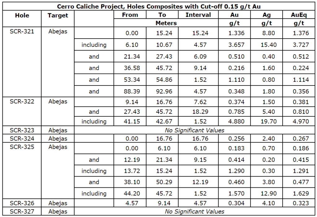
| Cerro Caliche Project, Holes Composites with Cut-off 0.15 g/t Au | ||||||||
| Hole | Target | From | To | Interval | Au | Ag | AuEq | |
| meters | g/t | g/t | g/t | |||||
| SCR-311 | El Colorado | 19.81 | 22.86 | 3.05 | 0.423 | 2.70 | 0.435 | |
| and | 35.05 | 39.62 | 4.57 | 0.626 | 1.00 | 0.630 | ||
| SCR-312 | El Colorado | 10.67 | 16.76 | 6.09 | 0.209 | 3.20 | 0.224 | |
| SCR-313 | El Colorado | 30.48 | 51.82 | 21.34 | 0.557 | 6.10 | 0.585 | |
| including | 36.58 | 39.62 | 3.04 | 1.523 | 15.60 | 1.594 | ||
| and | 85.34 | 96.01 | 10.67 | 0.257 | 1.60 | 0.265 | ||
| SCR-314 | El Colorado | 3.05 | 6.10 | 3.05 | 1.185 | 1.80 | 1.193 | |
| including | 3.05 | 4.57 | 1.52 | 2.190 | 2.70 | 2.202 | ||
| and | 68.58 | 70.10 | 1.52 | 1.075 | 5.70 | 1.101 | ||
| and | 79.25 | 86.87 | 7.62 | 0.720 | 2.60 | 0.732 | ||
| including | 80.77 | 82.30 | 1.53 | 1.635 | 1.70 | 1.643 | ||
| SCR-315 | El Colorado | 7.62 | 18.29 | 10.67 | 1.183 | 2.50 | 1.241 | |
| including | 15.24 | 16.76 | 1.52 | 3.270 | 33.90 | 3.426 | ||
| and | 28.96 | 33.53 | 4.57 | 1.087 | 2.10 | 1.097 | ||
| including | 32.00 | 33.52 | 1.53 | 2.280 | 4.70 | 2.302 | ||
| and | 48.77 | 53.34 | 4.57 | 0.503 | 0.70 | 0.506 | ||
| and | 88.39 | 91.44 | 3.05 | 0.230 | 0.50 | 0.232 | ||
| and | 97.54 | 128.02 | 30.48 | 0.437 | 1.50 | 0.444 | ||
| including | 108.20 | 111.25 | 3.05 | 1.138 | 1.90 | 1.146 | ||
| including | 121.92 | 123.44 | 1.52 | 1.080 | 2.80 | 1.093 | ||
| SCR-316 | San Quintin | 9.14 | 13.72 | 4.58 | 0.262 | 0.30 | 0.264 | |
| and | 25.91 | 28.96 | 3.05 | 0.256 | 0.90 | 0.260 | ||
| SCR-317 | Buena Suerte | 53.34 | 56.39 | 3.05 | 0.296 | 1.90 | 0.304 | |
| SCR-318 | Buena Suerte | 15.24 | 18.29 | 3.05 | 0.934 | 5.30 | 0.958 | |
| including | 15.24 | 16.76 | 1.52 | 1.445 | 8.40 | 1.484 | ||
| and | 30.48 | 32.00 | 1.52 | 9.570 | 1.20 | 9.576 | ||
| and | 51.82 | 80.77 | 28.95 | 1.021 | 1.20 | 1.027 | ||
| including | 62.48 | 64.01 | 1.53 | 2.070 | 2.20 | 2.080 | ||
| including | 70.10 | 73.15 | 3.05 | 2.706 | 2.40 | 2.717 | ||
| SCR-319 | Buena Suerte | 16.76 | 35.05 | 18.29 | 0.333 | 7.50 | 0.367 | |
| SCR-320 | Buena Suerte | 13.72 | 21.34 | 7.62 | 0.339 | 5.60 | 0.365 | |
| and | 33.53 | 38.10 | 4.57 | 0.851 | 4.80 | 0.873 | ||
| including | 35.05 | 36.58 | 1.53 | 2.110 | 8.00 | 2.147 | ||
| and | 50.29 | 54.86 | 4.57 | 0.240 | 1.70 | 0.248 | ||
| and | 57.91 | 60.96 | 3.05 | 0.181 | 0.20 | 0.182 |
Drill collar locations, azimuths and dips for the drill holes included are provided in the table below
| Drill Collar Locations (NAD 1927 UTM Zone 12N) | |||||||
| Drill Hole | Zone | Easting | Northing | Elevation | Depth (m) | Dip | Azimuth |
| SCR-311 | El Colorado | 536,130 | 3,364,461 | 1,260 | 112.78 | -66 | 192 |
| SCR-312 | El Colorado | 536,088 | 3,364,474 | 1,273 | 82.30 | -45 | 270 |
| SCR-313 | El Colorado | 536,102 | 3,364,587 | 1,322 | 100.58 | -45 | 235 |
| SCR-314 | El Colorado | 536,140 | 3,364,621 | 1,327 | 121.92 | -45 | 230 |
| SCR-315 | El Colorado | 536,165 | 3,364,651 | 1,321 | 131.06 | -45 | 217 |
| SCR-316 | San Quintin | 536,625 | 3,364,517 | 1,286 | 100.58 | -45 | 275 |
| SCR-317 | Buena Suerte | 536,632 | 3,364,579 | 1,241 | 100.58 | -45 | 270 |
| SCR-318 | Buena Suerte | 536,579 | 3,364,703 | 1,280 | 83.82 | -45 | 235 |
| SCR-319 | Buena Suerte | 536,538 | 3,364,701 | 1,286 | 82.30 | -45 | 235 |
| SCR-320 | Buena Suerte | 536,495 | 3,364,817 | 1,359 | 121.92 | -45 | 235 |
Quality Assurance/Quality Control (“QA/QC”) Measures and Analytical Procedures
Drill samples are collected with an airstream cyclone and passed into a splitter that divides each sample into quarters. The quartered samples are then bagged and sealed with identification. The sample group has blanks, standards and duplicates inserted into the sample stream.
ALS-Chemex collects the samples and transports them directly to the preparation laboratory in Hermosillo, Sonora. At the laboratory, part of each sample is reduced through crushing, splitting and pulverization from which 200 grams is sent to the ALS-Chemex assay laboratory in Vancouver. Thirty grams undergoes fire assay for gold with the resulting concentrated button of material produced is dissolved in acids and the gold is determined by atomic absorption. Another quantity of the sample is dissolved in four acids for an ICP multi-element analysis.
No QA/QC issues were noted with the results received from the laboratory.
Geologic Description
Cerro Caliche is located 45 kilometers east southeast of Magdalena de Kino in the Cucurpe-Sonora Mega-district of Sonora, Mexico. Multiple historic underground mines were developed in the concession including Cabeza Blanca, Los Cuervos, Japoneses, Las Abejas, Boluditos, El Colorado, Veta de Oro and Espanola. Mineralization types of the Cucurpe-Sonora Mega-district include variants of epithermal low sulfidation veins and related mineralized dikes and associated volcanic domes. Local altered and mineralized felsic dikes cut the mineralized meta-sedimentary rock units and may be associated with mineralization both in the dikes and meta-sedimentary rocks.
Qualified Person Statement
Stephen Kenwood, P.Geo., a Director of Sonoro, is a Qualified Person within the context of National Instrument 43-101 (NI 43-101) and has read and approved this news release. Readers are cautioned that the presence of mineralization in historic mines adjacent to, or on, Cerro Caliche is not necessarily indicative of economic gold mineralization residing in the concessions held by the Company.
About Sonoro Gold Corp.
Sonoro Gold Corp. is a publicly listed exploration and development company with two exploration-stage precious metal properties in Sonora State, Mexico. The Company has highly experienced operational and management teams with proven track records for the discovery and development of natural resource deposits.
On behalf of the Board of Sonoro Gold Corp.
Per: “Kenneth MacLeod”
Kenneth MacLeod
President & CEO
For further information, please contact:
Sonoro Gold Corp. – Tel: (604) 632-1764
Email: info@sonorogold.com
- Published in Mining, News Home, Sonoro Gold
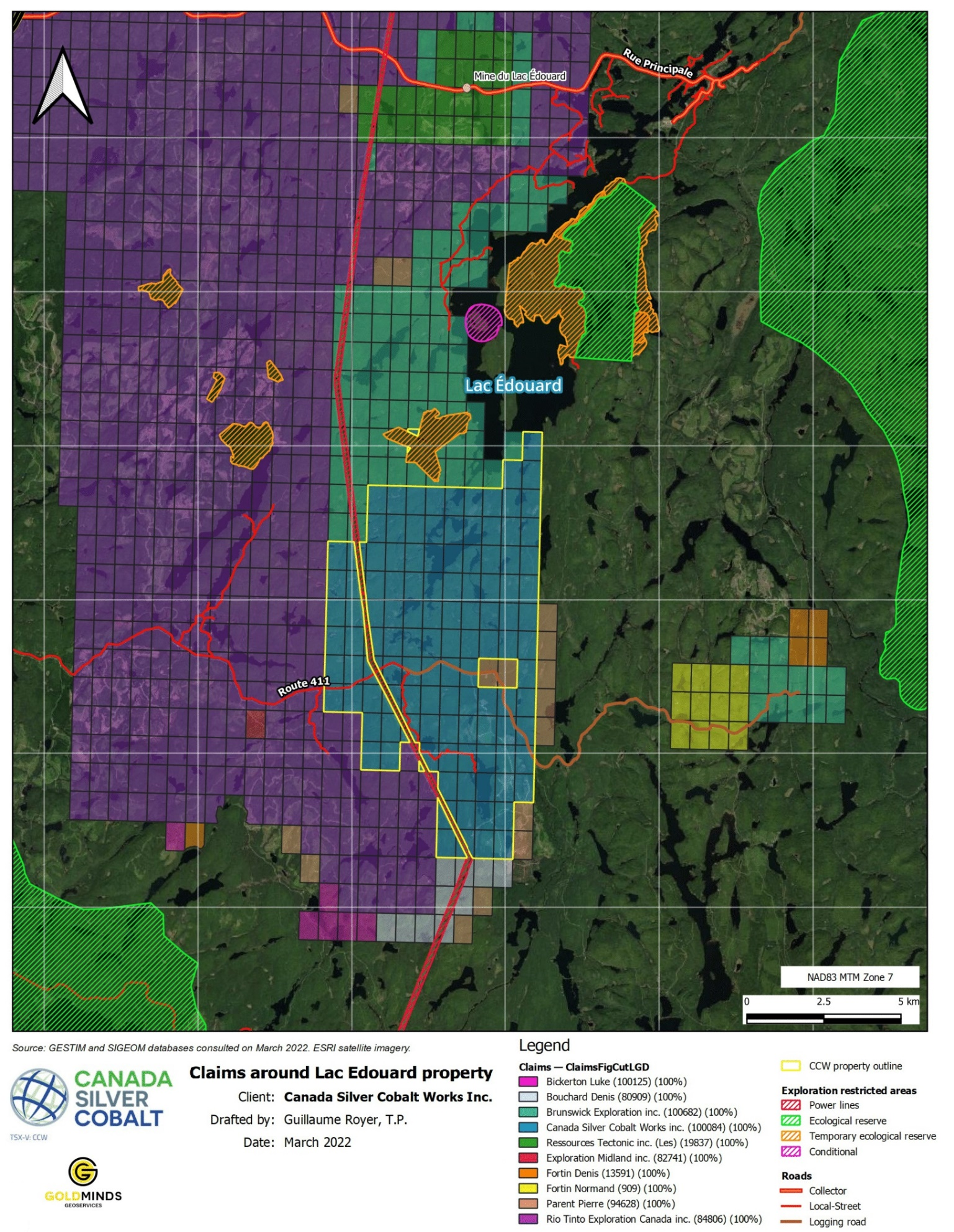
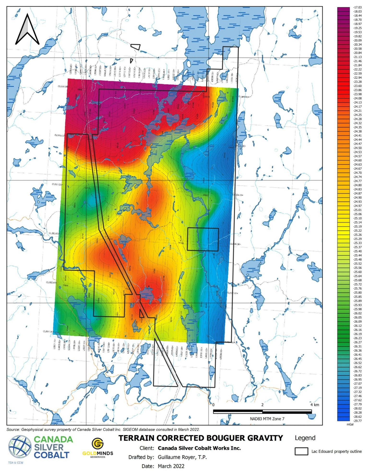
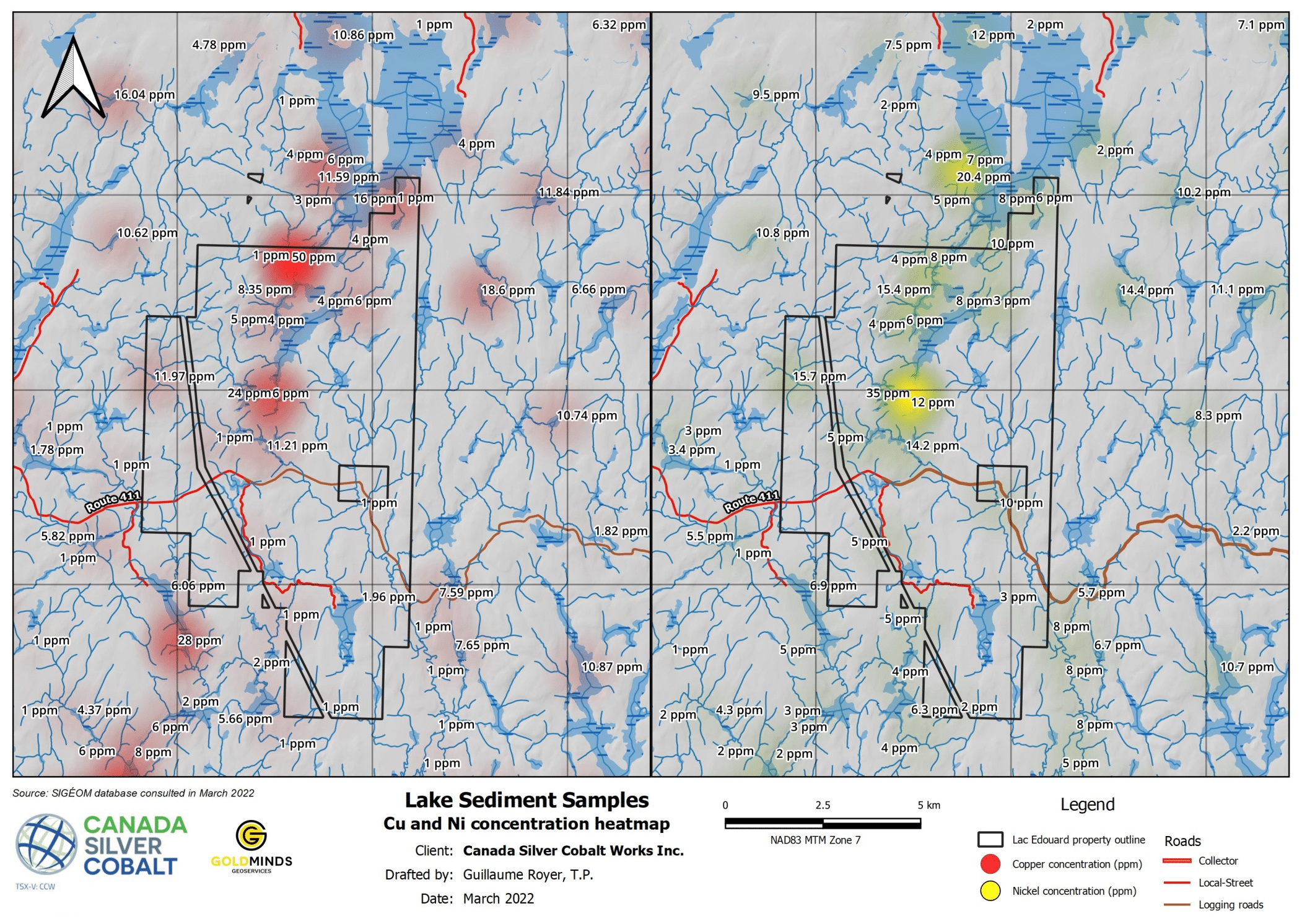
Canada Silver Cobalt Announces Airborne VTEM Geophysical Survey at its Lowney-Lac Edouard Property East of La Tuque in Central Quebec
The VTEM Plus survey will be flown via helicopter later in June, and aims to identify discrete conductive anomalies near surface
Coquitlam, BC – TheNewswire – May 24, 2022 – Canada Silver Cobalt Works Inc. (TSXV:CCW) (OTC:CCWOF) (Frankfurt:4T9B) (the “Company” or “Canada Silver Cobalt”) is pleased to announce it is planning an airborne VTEM Plus geophysical survey at its Lowney-Lac Edouard property south of the historical Lac Edouard Ni-Cu-Co mine in Central Quebec.
The property is of particular interest to the technical team due to several important factors:
- 1) The significant regional gravity anomaly that was identified by a previous airborne SGL survey (please see Figure 2).
- 2) The positive geological context, including a favorable lithological unit that appears to correlate with the gravity anomaly.
- 3) The sediment lake samples that returned elevated nickel and copper, which appears to also correlate with the gravity anomaly (please see Figure 3).
- 4) The proximity to the old Lac Edouard Ni-Cu-Co past producing mine.
The VTEM survey will be completed via helicopter by Geotech, is a global leader in technological innovation for airborne geophysical survey mapping, interpretation and analysis. The Company intends to identify near surface conductors which will help guide the field work this summer. The VTEM survey and field work will help provide a better understanding of the area and hopefully lead to a drill program. In addition, the property is bordered by several other large companies such as Rio Tinto Exploration Canada and Brunswick Exploration Inc. (please see Figure 1).
“We believe that a VTEM survey will provide the necessary information to better understand the property. Based on what we have so far, this property has great potential and fits within our objective to become an important supplier of battery metals material to the EV market. The fact that we have big players surrounding us shows that we’re in the right location.” states Matt Halliday, P.Geo., President, COO and VP Exploration.
Qualified person
The technical information in this news release has been reviewed by Claude Duplessis, P.Eng., GoldMinds Geoservices Inc., a member of the Quebec Order of Engineers, and is a qualified person in accordance with the National Instrument 43- 101 standards.
About Canada Silver Cobalt Works Inc.
Canada Silver Cobalt Works Inc. recently discovered a major high-grade silver vein system at Castle East located 1.5 km from its 100%-owned, past-producing Castle Mine near Gowganda in the prolific and world-class silver-cobalt mining district of Northern Ontario. The Company has completed a 60,000m drill program aimed at expanding the size of the deposit with an update to the resource estimate underway.
In May 2020, based on a small initial drill program, the Company published the region’s first 43-101 resource estimate that contained a total of 7.56 million ounces of silver in Inferred resources, comprising very high-grade silver (8,582 grams per tonne un-cut or 250.2 oz/ton) in 27,400 tonnes of material from two sections (1A and 1B) of the Castle East Robinson Zone, beginning at a vertical depth of approximately 400 meters. Note that mineral resources that are not mineral reserves do not have demonstrated economic viability. Please refer to Canada Silver Cobalt Works Press Release May 28, 2020, for the resource estimate. Report reference: Rachidi, M. 2020, NI 43-101 Technical Report Mineral Resource Estimate for Castle East, Robinson Zone, Ontario, Canada, with an effective date of May 28, 2020, and a signature date of July 13, 2020.
The Company also has: (1) 14 battery metals properties in Northern Quebec where it has recently completed a nearly 10,000-metre drill program on the Graal property; and (2) the prospective 1,000-hectare Eby-Otto gold property close to Agnico Eagle’s high-grade Macassa Mine near Kirkland Lake, Ontario where it will be exploring in 2022.
Canada Silver Cobalt’s flagship silver-cobalt Castle mine and 78 sq. km Castle Property feature strong exploration upside for silver, cobalt, nickel, gold, and copper. With underground access at the fully owned Castle Mine, an exceptional high-grade silver discovery at Castle East, a pilot plant to produce cobalt-rich gravity concentrates, a processing facility (TTL Laboratories) in the town of Cobalt, and a proprietary hydrometallurgical process known as Re-2Ox (for the creation of technical-grade cobalt sulphate as well as nickel-manganese-cobalt (NMC) formulations), Canada Silver Cobalt is strategically positioned to become a Canadian leader in the silver-cobalt space. More information at www.canadasilvercobaltworks.com
“Frank J. Basa”
Frank J. Basa, P. Eng.
Chief Executive Officer
For further information, contact:
Frank J. Basa, P.Eng.
Chief Executive Officer
416-625-2342
Neither the TSX Venture Exchange nor its Regulation Service Provider (as that term is defined in the policies of the TSX Venture Exchange) accepts responsibility for the adequacy or accuracy of this release.
Caution Regarding Forward-Looking Statements
This news release may contain forward-looking statements which include, but are not limited to, comments regarding future financings, if any, pursuant to the short form base shelf prospectus referred to above, and comments that involve future events and conditions, which are subject to various risks and uncertainties. Except for statements of historical facts, comments that address resource potential, upcoming work programs, geological interpretations, receipt and security of mineral property titles, future financings, availability of funds, and others are forward-looking. Forward-looking statements are not guarantees of future performance and actual results may vary materially from those statements. General business conditions are factors that could cause actual results to vary materially from forward-looking statements. A detailed discussion of the risk factors encountered by Canada Silver Cobalt is available in the Company’s Annual Information Form dated July 19, 2021 for the fiscal year ended December 31, 2020 available under the Company’s profile on SEDAR at www.sedar.com .
Click Image To View Full Size
Figure 1: Property location map showing the Company claim package and the surrounding companies.
Click Image To View Full Size
Figure 2: Property location and location of gravity anomaly.
Click Image To View Full Size
Figure 3: Property location and heat map showing elevated Copper and Nickel values from the sediment samples.
- Published in Canada Cobalt Works, Mining, News Home