TRU Precious Metals Reports Additional Drill Results at Twilite Gold Project and Prepares for Drilling at Golden Rose Project
TRU Precious Metals Corp. (TSXV: TRU) (OTCQB: TRUIF) (FSE: 706) (“TRU” or the “Company”) is pleased to announce additional assays from its 12-hole, Phase 1 diamond drilling program at its 100%-owned Twilite Gold Project in the Central Newfoundland Gold Belt (“Twilite Gold”). The Company is also providing an update on drilling preparations at its flagship Golden Rose Project (“Golden Rose”), also in the Central Newfoundland Gold Belt located along the deposit-bearing Cape Ray – Valentine Lake Shear Zone.
Highlights from the latest batch of Twilite Gold drill results (Tables 1 and 2) include:
- 6.00 metres (m) grading 1.06 grams per ton (g/t) gold (Au) in drill hole TL-21-18.
- 3.00m grading 0.85 g/t Au in drill hole TL-21-20.
- Robust shear zone hosted quartz breccia system remains open along strike in all directions.
Barry Greene, VP of Property Development and Director of TRU, commented: “The strength of the alteration, brecciation and mineralization remains intact as the gold system is continuing to the southeast. As is common, structural complexities play a part in the distribution of gold as the gold zone is deeper than expected. We are working to determine if this is an offset or part of a separate zone.”
Table 1. Uncut Assay Highlights
| Hole No. | From (m) | To (m) | Interval (m) | Au (g/t) | Zone |
| TL21-18* | 191.00 | 197.00 | 6.00 | 1.06 | Fort Knox |
| TL21-20 | 97.32 | 98.00 | 0.68 | 0.33 | |
| And | 225.00 | 228.00 | 3.00 | 0.85 | |
| And | 299.00 | 301.00 | 2.00 | 0.53 |
* Results based on partial recovery from a fault zone.

Figure 1. Plan Map of Twilite Gold Drilling
To view an enhanced version of Figure 1, please visit:
https://orders.newsfilecorp.com/files/5993/96577_4f460c3ea4b2183e_001full.jpg
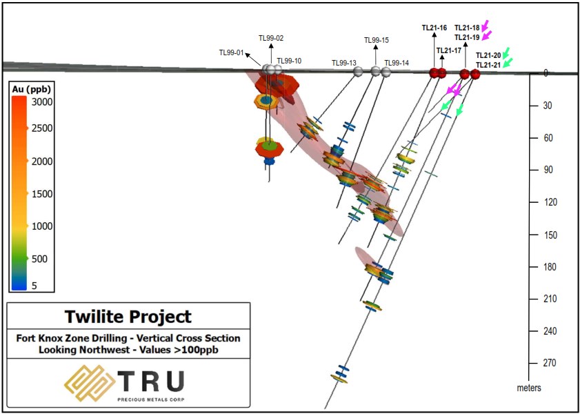
Figure 2. Cross Section of Twilite Gold Drilling
To view an enhanced version of Figure 2, please visit:
https://orders.newsfilecorp.com/files/5993/96577_4f460c3ea4b2183e_002full.jpg
Table 2. Collar Details for TL-21-18 to TL-21-21
| Hole No. | Azimuth (°) | Dip (°) | Length (m) | UTM E | UTM N |
| TL21-18 | 239.9 | -65.9 | 224 | 589850 | 5408773 |
| TL21-19* | 241.0 | -46.8 | 47 | 589914 | 5408700 |
| TL21-20 | 238.4 | -66.0 | 362 | 589936 | 5408680 |
| TL21-21* | 237.6 | -46.4 | 122 | 589936 | 5408680 |
* Abandoned prematurely due to bad ground conditions.
TRU Co-Founder and CEO Joel Freudman added: “We are pleased that we continue to encounter gold mineralization in the results from our recently-completed inaugural drill program, and we look forward to the remaining results, which will guide future drilling at Twilite Gold. I am even more excited about our imminent 5,000-metre diamond drill program at our flagship Golden Rose Project – with permitting now in hand, drilling will soon be a reality. Over the past 4 months, our team has worked ardently in preparation. Golden Rose represents a unique opportunity for TRU for numerous reasons, with the key drivers being that it is well-situated both geologically and geographically, sandwiched between two neighbours with significant known gold deposits.”
Golden Rose Drilling Preparations
At Golden Rose, drill permitting is now in place and a drill contract has been awarded to Logan Drilling Limited for a planned 5,000m diamond drilling campaign, scheduled to begin in early to mid-October. The Company is working closely with GoldSpot Discoveries Corp. in laying out and targeting its drill program.
TRU’s main objectives for this drill program are (1) infill drilling at the South Woods Lake Gold Zone, to better delineate the known mineralization there, and (2) exploratory drilling at the recently-optioned King George IV claims in hopes of making a new discovery there, following the Company’s discovery of visible gold grains on such claims this summer, as previously announced on July 14, 2021.
As additional preparatory steps, the Company recently completed a 1,568 line-kilometer airborne magnetic gradiometer survey over select portions of Golden Rose, including the King George IV claims. The Company is also preparing for an IP/Resistivity survey at the King George IV claims.
Drilling Quality Assurance/Quality Control (“QA/QC”)
All NQ core is sampled, cut by core saw, and split by Company personnel, and put into bags with unique sample tags for identification. The bags are sealed with a security tag and are then transported directly to the lab by TRU staff. All rock samples are analyzed at Eastern Analytical Ltd. (“Eastern Analytical”) of 403 Little Bay Road, Springdale, NL, a commercial laboratory that is ISO/IEC 17025 accredited and independent of TRU. Eastern Analytical pulverized 1000 grams of each sample to 95% < 89 μm. Samples are analyzed using fire assay (30g) with AA finish and an ICP-34, four acid digestion followed by ICP-OES analysis. All samples with visible gold or assaying above 1.00 g/t Au are further assayed using metallic screen to mitigate the presence of the nugget effect of coarse gold. Standards and blanks are inserted at defined intervals for QA/QC purposes by the Company as well as Eastern Analytical. The TRU exploration program design is consistent with industry best practices and the program is carried out by qualified persons employing a QA/QC program consistent with National Instrument 43-101.
Qualified Person
Barry Greene, P.Geo. (NL) is a qualified person as defined by National Instrument 43-101 and has reviewed and approved the contents and technical disclosures in this press release. Mr. Greene is a director and officer of the Company and owns securities of the Company.
About TRU Precious Metals Corp.
TRU has assembled a portfolio of gold exploration properties in the highly prospective Central Newfoundland Gold Belt. The Company has an option with a subsidiary of TSX-listed Altius Minerals Corporation to purchase 100% of the Golden Rose Project, located along the deposit-bearing Cape Ray – Valentine Lake Shear Zone. TRU also owns 100% of the Twilite Gold Project, located along the same Shear Zone, and 3 early-stage properties including 2 near New Found Gold Corp.’s high-grade Queensway Project. TRU’s common shares trade on the TSX Venture Exchange under the symbol “TRU”, on the OTCQB Venture Market under the symbol “TRUIF”, and on the Frankfurt exchange under the symbol “706”.
TRU is a portfolio company of Resurgent Capital Corp. (“Resurgent”), a merchant bank providing venture capital markets advisory services and proprietary financing. Resurgent works with promising public and pre-public micro-capitalization companies listing on Canadian stock exchanges. For more information on Resurgent and its portfolio companies, please visit Resurgent’s website at https://www.resurgentcapital.ca/
For further information about TRU, please contact:
Joel Freudman
Co-Founder, President & CEO
TRU Precious Metals Corp.
Phone: 1-855-760-2TRU (2878)
Email: ir@trupreciousmetals.com
Website: www.trupreciousmetals.com
To connect with TRU via social media, below are links:
Twitter
https://twitter.com/corp_tru
LinkedIn
https://www.linkedin.com/company/tru-precious-metals-corp
YouTube
https://www.youtube.com/channel/UCHghHMDQaYgS1rDHiZIeLUg/
Facebook
https://www.facebook.com/TRU-Precious-Metals-Corp-100919195193616
- Published in Mining, News Home, Tru Precious Metals
Canbud Enters into Memorandum of Understanding for Psilocybin Producing Mushroom Research and Development
Canbud Distribution Corp. (CSE: CBDX) (FSE: CD0) (the “Corporation” or “Canbud“) is pleased to announce that on September 3,2021 it has entered into a memorandum of understanding (the “MOU“) with the College of Agriculture, Science and Education (“CASE“), establishing a business and research and development (“R&D“) relationship between the parties. CASE is a tertiary educational institution located in Port Antonio, Jamaica, with a tripartite mandate of teaching, research, and outreach.
Under the terms of the MOU, Canbud and CASE formed a commercial relationship focused on the research and development of healing practices facilitated by psilocybin producing mushrooms, and the manufacture of consumer products from psilocybin mushrooms for health benefits. The MOU includes, among other things, provisions to reflect the following key agreements and understandings between the parties:
- The term of the MOU commenced on September 3, 2021 and ends on August 22, 2022.
- During the term Canbud will lease its existing mobile commercial facility to CASE at no cost for use in an R&D capacity and for commercial production, based on terms to be agreed separately.
- Canbud will provide to CASE up to $10,000 of funding for a mutually approved R&D program intended to evaluate the potential uses of psilocybin and other psychedelic properties within mushrooms. Any results of these research will be made available to Canbud for its exclusive use.
- If and when CASE commences commercial production, the parties intend to negotiate and enter into a separate agreement, which would provide, among other things, that Canbud would have right of first refusal to acquire any commercial production, and at least 50% of commercial production would be purchased by Canbud on agreed terms. CASE would have the ability to sell any production not purchased by Canbud, with economics to be shared by CASE and Canbud on terms to be agreed by the parties.
- The respective ownership rights to any intellectual property are to be agreed by the parties prior to any commercialization or monetization of these rights.
- CASE would seek to acquire all the necessary research licenses to facilitate the exportation of mushrooms to both Canada and the United States of America once commercial production plans are finalized, subject to applicable laws.
- CASE will manage and operate the research laboratory.
Steve Singh, CEO of Canbud, notes “We are extremely pleased to enter into research partnership with CASE that is intended to help enable Canbud to undertake a scientific approach to understanding the medicinal properties of specific mushrooms and potentially replicate the cultivation of those spores on a commercial scale in the future.”
About Canbud Distribution Corp.
Canbud is a science and technology health and wellness company carrying on business in the plant based, psychedelic pharmaceutical and non-psychedelic nutraceutical, and hemp cannabinoid (CBD) vertical markets.
- Published in Canbud Distribution, News Home
Canada Silver Cobalt Completes Commissioning of Secondary Crushing Circuit at Temiskaming Testing Labs
Canada Silver Cobalt Works Inc. (TSXV:CCW) (OTC:CCWOF) (Frankfurt:4T9B) (the “Company” or “Canada Silver Cobalt”) is pleased to announce that it has successfully commissioned the secondary crushing and screening circuit at its fully owned TTL (Temiskaming Testing Labs) bulk processing facility located in Cobalt, Ontario using low-grade waste rock.
“The company is now positioned to process mine development rock to recover native silver and produce feed to a planned pilot plant gravity circuit to produce marketable concentrates for evaluation as part of a PEA (preliminary economic assessment). The Company plans to use the secondary crushing and screening circuit during the exploration stage of mine development for metallurgical accounting and grade control by means of a bulk sample to be taken from the proposed planned ramp at the Castle East Robinson Zone. The data and information gathered during the processing of the mine rock may be used to develop a mill process flowsheet,” commented Frank J. Basa, P.Eng.
Crushing and Screening Circuit Highlights:
- – The mine waste rock in this test run was initially processed with a mobile, tracked screening plant with a 125 tonne per hour capacity. This screening plant produces three different product sizes that include greater than 3” (coarse), between 3” and ½” (medium), and less than ½” (fine).- The screened mine waste rock was processed by the mobile screening plant and brought to the TTL facility for further crushing and screening. The facility can accept all three sizes produced by the mobile screening plant. Pre-screening the mine waste rock provides for the increased throughput capacity at the TTL secondary crushing and screening circuit.- The TTL facility has a complete crushing and screening bulk processing plant with a 20 tonne per hour capacity. This facility can produce three different product sizes that include greater than 1/4” (coarse), between 1/4” and 20-mesh (medium), and less than 20 mesh (fine).- The final product of the crushing circuit at TTL will allow the production of marketable gravity concentrates or will be used as pilot plant feed for the Re-20x process, which has produced EV battery and other related battery end-products.
You can find a video showing the mobile screening plant and TTL crushing circuit in action HERE or via the Company’s website at www.canadasilvercobaltworks.com
The Company continues with the planned 60,000-meter drill program at Castle East with 2 diamond drills running and over 43,000 meters completed to date. Environmental studies are ongoing for the ramp for the Castle East Robinson Zone and are slated to be completed in the first quarter 2022.
Qualified Person
The technical information in this news release was prepared under the supervision of Mr. Frank J. Basa, P.Eng., Chief Executive Officer of Canada Silver Cobalt Works Inc., a qualified person in accordance with National Instrument 43-101.
About Canada Silver Cobalt Works Inc.
Canada Silver Cobalt Works Inc. recently discovered a major high-grade silver vein system at Castle East located 1.5 km from its 100%-owned, past-producing Castle Mine near Gowganda in the prolific and world-class silver-cobalt mining district of Northern Ontario. This discovery has the highest silver resource grade in the world, with recent drill intercepts of up to 89,853 grams/tonne silver (2,621 oz/ton Ag). A drill program is underway to expand the size of the deposit with an update to the resource estimate scheduled for the first quarter of 2022.
In May 2020, based on a small initial drill program, the Company published the region’s first 43-101 resource estimate that contained a total of 7.56 million ounces of silver in Inferred resources, comprising very high-grade silver (8,582 grams per tonne un-cut or 250.2 oz/ton) in 27,400 tonnes of material from two sections (1A and 1B) of the Castle East Robinson Zone, beginning at a vertical depth of approximately 400 meters. Note that mineral resources that are not mineral reserves do not have demonstrated economic viability. Please refer to Canada Silver Cobalt Works Press Release May 28, 2020, for the resource estimate. Report reference: Rachidi, M. 2020, NI 43-101 Technical Report Mineral Resource Estimate for Castle East, Robinson Zone, Ontario, Canada, with an effective date of May 28, 2020, and a signature date of July 13, 2020.
Canada Silver Cobalt’s flagship silver-cobalt Castle mine and 78 sq. km Castle Property feature strong exploration upside for silver, cobalt, nickel, gold, and copper. With underground access at the fully owned Castle Mine, an exceptional high-grade silver discovery at Castle East, a pilot plant to produce cobalt-rich gravity concentrates on site, a processing facility (TTL Laboratories) in the town of Cobalt, and a proprietary hydrometallurgical process known as Re-2Ox (for the creation of technical-grade cobalt sulphate as well as nickel-manganese-cobalt (NMC) formulations), Canada Silver Cobalt is strategically positioned to become a Canadian leader in the silver-cobalt space. More information at www.canadasilvercobaltworks.com .
“Frank J. Basa”
Frank J. Basa, P. Eng.
Chief Executive Officer
For further information, Contact:
Frank J. Basa, P.Eng.
Chief Executive Officer
416-625-2342
- Published in Canada Cobalt Works, Mining, News Home
Granada Gold Intersects up to 7.16 G/T over 5.60m and 95.00 G/T Gold over 0.50m in Drill Program Update
Granada Gold Mine Inc. (TSXV:GGM) (OTC:GBBFF) (Frankfurt:B6D) (the “Company” or “Granada”) is pleased to announce additional drill results from its on-going drill program at its Granada Gold project with multiple new assays from its 200-Series drill holes with grades of up to 7.16 g/t Au over 5.60m and 95.00 g/t Au over 0.50m.
Drilling Highlights
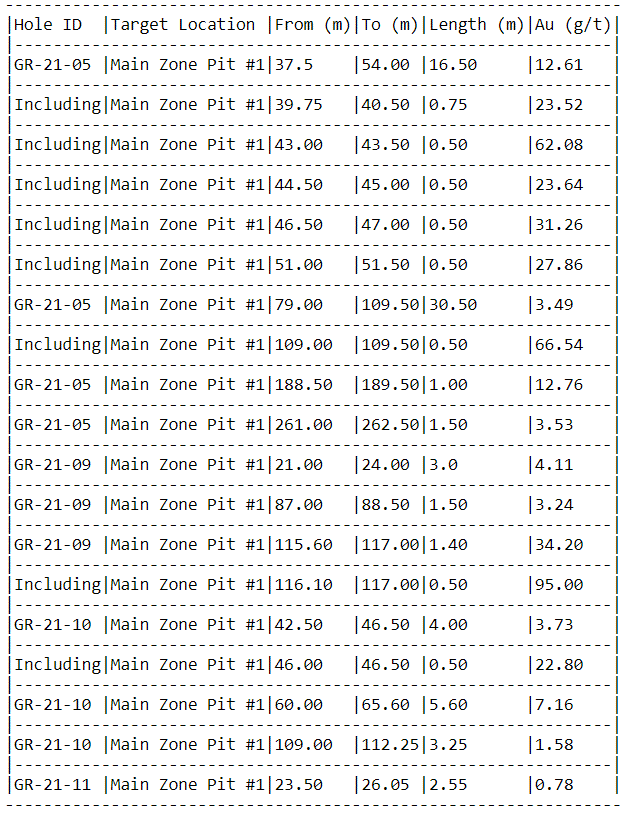
– The 200-Series drill holes (GR-21-05, GR-21-09, GR-21-10, and GR-21-11) were designed to determine the variability of gold mineralization of the main vein zone within the eastern extension of Pit #1 by drilling down the dip of the structure.
– These assay results confirm the significant extent of localized high-grade gold mineralization within the structure as well as prove the continuity of the mineralization over much broader intervals up to 263m down-dip of the main zone below Pit #1.
– Previously released results from GR-21-05 graded 3.49 g/t over 30.50m (including 66.54 g/t over 0.50m (Press release June 21, 2021), and 12.61 g/t over 16.50m (including 62.06 g/t over 0.50m), with new results grading 12.76 g/t over 1.00m, and 3.53 g/t over 1.50m.
– GR-21-09 intersected 4.11 g/t over 3.00m, 3.24 g/t over 1.50m, 34.20 g/t over 1.40m including 95.00 g/t over 0.50m.
– GR-21-10 intersected 3.73 g/t over 4.00m, 7.16 g/t over 5.60m, and 1.58 g/t over 3.25m.
– GR-21-11 intersected 2.65 g/t over 3.0m.
“The assay results in these drill holes proved the continuity along the main structure and confirmed the extent to depth of high-grade gold mineralization. This supports the view that our gold grades and occurrences are continuous and have substantial thickness to the zone.” said Frank J. Basa, P.Eng., President and CEO.
The mineralized zone beneath the eastern extension of Pit #1 contains a collection of multiple veins with sulfide mineralized halos. The zone contains 3 distinct sub-parallel mineralized veins which connect with the former Pit #1 to the west. The true thickness of these mineralized structures varies between 2m and 11 m. The main zone of these 3 structures is what was tested with the 200-Series drill holes.
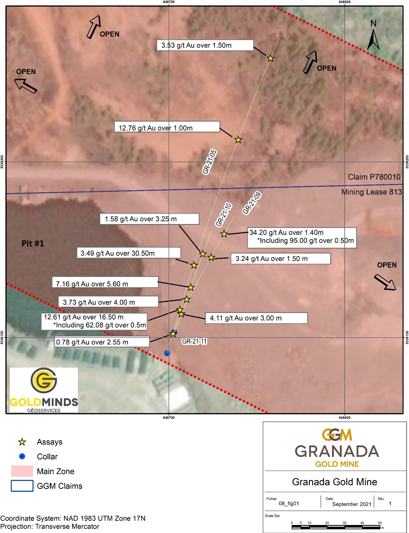
Click Image To View Full Size
Figure 1: Plan Map Showing Drill Hole and Assay Locations just East of Pit #1
Table 1: Sample Details
The 200-Series holes were designed with an azimuth of 10-30 degrees to the north attempting to drill down the vein structures as opposed to obliquely. Normally, the drill holes are aimed southward which are designed to intersect the structures at a high angle, with an azimuth in the general range of 170-190 degrees. Previous intercepts into this structure have returned 6.95 g/t gold over 3.50 meters ( true thickness) in hole GR-11-380 (Press release September 18, 2012), and 11.45 g/t gold over 33.00 meters in hole GR-19-A (Press Release January 9, 2020). The grades we see in the 200-Series drill holes validate the grades encountered previously in other drill programs and confirm the continuity of the gold mineralization. It also demonstrates that the system is a multi-vein system (as opposed to a single discrete vein). This is why the true thickness of the gold mineralization at Granada varies significantly from small high-grade intervals, such as 95.00 g/t over 0.50m, to even 0.31 g/t over 301m (Press Release September 18, 2012) depending on the location within the property and cut-off grade used for the calculation.
Location
The Granada Gold project is located near Rouyn-Noranda adjacent to the prolific Cadillac Break shear zone, which is hosted in Pontiac metasedimentary rocks, granites, and younger syenite sills along the Granada shear zone (LONG Bars Zone). The project is located on the same side of the Cadillac Fault as the Canadian Malartic mine property, which has historically produced 12.7 million Ounces of gold from 1935 to 2010 with an additional 5 million ounces as of June 18, 2020 (Canadian Malartic Technical Report of March 25, 2021 & Le Citoyen June 19, 2020).
Qualified person
The technical information in this news release has been reviewed by Claude Duplessis, P.Eng., GoldMinds Geoservices Inc., a member of the Québec Order of Engineers, and is a qualified person in accordance with the National Instrument 43- 101 standards.
Quality Control and Reporting Protocols
All NQ core assays reported for Wedges of 2020 holes were obtained by either 1-kilogram screen metallic fire assay or standard 50-gram fire assay (with either atomic absorption or gravimetric finish). This was completed at the SGS Laboratory in Vancouver, British Columbia with the sample preparation completed in Val d’Or, Québec. The 2021 assay results are from ALS laboratory in Val d’Or. The screen metallic fire assay method is pre-selected by the geologist or geological engineer when samples contain visible gold. The drill program, quality assurance, quality control (QAQC), and interpretation of results is performed by qualified persons employing procedures consistent with NI 43-101 and industry best practices. Standards and blanks are included with every 20 samples for QAQC purposes for this program in addition to the lab QAQC.
Mineral Resource Estimate
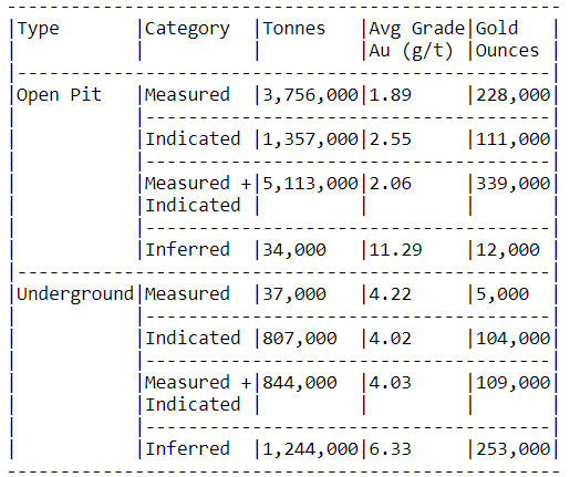
On March 15, 2021 the Company released an updated NI 43-101 resource estimate for the Granada Gold project (Please see January 29, 2021 news release) with a combined total of 713,000 gold ounces of measured, indicated, and inferred. This estimate contains 351,000 gold ounces of combined measured, indicated, and inferred for the open pit and 362,000 gold ounces of combined measured, indicated, and inferred for the underground. Please see Table 2 below for full details. Report reference: Granada Gold Project Mineral Resource Estimate Update, Rouyn-Noranda, Quebec, Canada authored by Yann Camus, P.Eng. and Maxime Dupéré, B.Sc, P.Geo., SGS Canada Inc. with an effective date of December 15, 2020 and signature date of March 15, 2021.
Table 2: Mineral Resource Estimate Showing Tonnes, Average Grade, and Gold Ounces
About Granada Gold Mine Inc.
Granada Gold Mine Inc. continues to develop and explore its 100% owned Granada Gold Property near Rouyn-Noranda, Quebec, and is adjacent to the prolific Cadillac Break. The Company owns 14.73 square kilometers of land in a combination of mining leases and claims. The company is currently undergoing a large drill program with 30,000m out of 120,000m complete. The drills are currently paused to provide the technical team with the necessary time to evaluate and assimilate existing data.
The Granada Shear Zone and the South Shear Zone contain, based on historical detailed mapping as well as from current and historical drilling, up to twenty-two mineralized structures trending east-west over five and a half kilometers. Three of these structures were mined historically from four shafts and three open pits. Historical underground grades were 8 to 10 grams per tonne gold from two shafts down to 236 m and 498 m with open pit grades from 3.5 to 5 grams per tonne gold.
The property includes the former Granada Gold underground mine which produced more than 50,000 ounces of gold at 10 grams per tonne gold in the 1930’s from two shafts before a fire destroyed the surface buildings. In the 1990’s, Granada Resources extracted a bulk sample (Pit #1) of 87,311 tonnes grading 5.17 g/t Au. They also extracted a bulk sample (Pit # 2) of 22,095 tonnes grading 3.46 g/t Au.
“Frank J. Basa”
Frank J. Basa, P. Eng.
Chief Executive Officer
For further information, Contact:
Frank J. Basa, P.Eng.
Chief Executive Officer
P: 416-625-2342
- Published in Granada Gold Mine, Mining, News Home
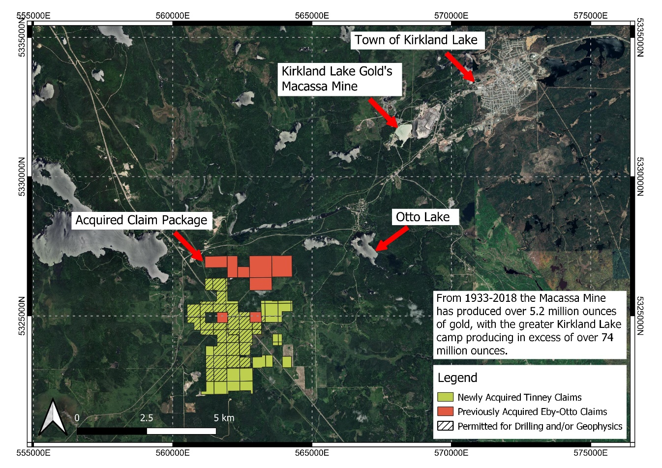
Canada Silver Cobalt Works’ New Gold Property Now Totals 810 Hectares with 610 Hectare Acquisition
Canada Silver Cobalt Works Inc. (TSXV:CCW) (OTC:CCWOF) (Frankfurt:4T9B) (the “Company” or “Canada Silver Cobalt”) is pleased to announce that it has entered into an Option Agreement dated August 15, 2021, to acquire the 610 hectares, known as the “Tinney” property (the “Property”) from a group of highly renowned prospectors (“Claim Holders”).
Acquisition Highlights:
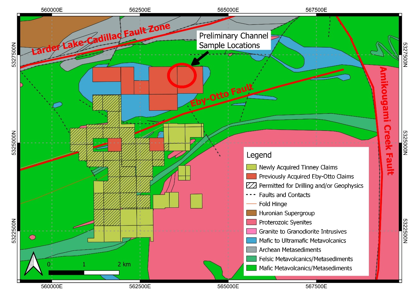
- – Property lies within the Abitibi Greenstone Belt in the prolific Kirkland Lake district and is located approximately 7 km south-west of the high-grade Macassa Gold Mine currently operated by Kirkland Lake Gold.- In addition, the 610 hectares included in this acquisition are adjacent to the 200 hectares recently optioned on August 3, 2021, from geologist Doug Robinson and partners. This increases the total area of the land package four-fold to a grand total of 810 hectares.- The acquisition provides further expansion of the Company’s precious metals portfolio into the well-established Kirkland Lake Gold camp located on the prolific Larder Lake-Cadillac Break.- Select claims have valid exploration permits that will allow a combination of mechanized drilling and/or surface geophysics (shown on Figure 1 and Figure 2). A well-organized exploration plan is currently being developed for the 2022 field season which may include geological mapping, the stripping of outcrops, and channel sampling. Results of this field season will dictate the drill program to follow on the property.
Company President, Matt Halliday, P.Geo. stated “These new gold properties have our geologists very excited about the 2022 field season. There are multiple geological features that are of extreme interest including three major fault structures: the Larder Lake Cadillac Deformation Zone (also referred to as Break or Fault Zone) 1km to the north, the Amikougami Creek Fault 5km to the east, and over 2km of the Eby-Otto Fault trending north-easterly through the property. The property is permit ready, we just need to put in the work.”
The structural zone surrounding the Eby-Otto Fault is marked by iron carbonate, silicification, chloritization, and large pyrite-mineralized zones up to 200 meters wide. According to OGS open file report OFR6184 quoting Meyer et el 2005, there are several gold deposits in the area that show similarities such as the Holloway Mine “Lightning Zone”, the Kerr Mine “Flow Ore”, and the “D Zone” at the Cheminis Mine. While these orebodies are not significant at surface, the evidence exists in the form of carbonatization, silicification, pyrite mineralization, and sporadic gold mineralization similar to what is encountered on these claims. In addition, geochemically anomalous gold and copper values have been recorded along the length of the Eby-Otto Fault as showings, pits, and small-scale shafts with values up to 5.8 g/t Au over 1.5m (0.17 oz/ton over 5’, AFRI 2.57388 2016). Further anomalous showings of gold, copper, and platinum occur within the mafic metavolcanics, mafic metasediments, and syenite intrusions scattered across the combined property.
Click Image To View Full Size
Figure 1: Location of newly acquired Tinney claims and previously acquired Eby-Otto claims in addition to showing proximity to Kirkland Lake Gold’s Macassa Mine.
Click Image To View Full Size
Figure 2: A closer look at the total property package showing the simplified regional geology, location of preliminary channel samples (news releases August 3, 2021), as well as three major faults of interest.
Details of the Property
The Eby-Otto and Tinney area was originally discovered by silver prospectors originating from the town of Cobalt prospecting for silver. But instead of silver, they found occurrences of gold near the shore of Otto Lake in 1906. This kickstarted the discovery of many gold mines in the area. Since then, there has been sporadic activity by various prospectors, geologists, and exploration companies exploring primarily for gold. Over the years there has been small scale trenching, pits, shafts, and small mining operations with low grade to anomalous values identified. This work has helped define the nature of the iron carbonate, silicification, chloritization, and large pyrite mineralized zones.
As previously mentioned, the rocks in this claim package show certain parallels at surface to the Holloway Mine, the Kerr Mine, and the Cheminis Mine. But it also shows similarities to the style of veins and host rocks encountered at the Macassa Mine, which is characterized by finely disseminated pyrite, wide alteration zones, and multiple generations of quartz veining and/or flooding. The Macassa Mine, which commenced operations in 1933, has produced more than 5.2 million ounces of gold, has benefited from new discoveries within its property over the years and still has one of the highest reserve grades in the world. The greater Kirkland Lake camp, situated along the Larder-Lake Cadillac Break, has collectively produced over 74 million ounces of gold.
The property contains three large faults that are of interest. The Larder Lake Cadillac Deformation Zone is one of the major gold-bearing deformation zones in the southern Abitibi subprovince. It hosts many gold mines such as the Cheminis and Kerr Addison and has many gold-bearing subsidiary faults (or splays) such as the “Main Break” (the dominant gold-bearing fault at the Macassa Mine) and the Eby-Otto Fault cutting through the Eby-Otto and Tinney claim package. The Amikougami Creek Fault is an important structural feature because it offsets certain gold-bearing faults including the ’04 Break at the Macassa Mine. To date, there has been no major discovery to the west of the Amikougami Creek Fault. The Eby-Otto Fault is another splay off the Larder Lake Cadillac Deformation Zone and there is strong potential for gold mineralization to exist along strike and at depth when considering the major alteration zones, sulphides, and quartz veins encountered on the property.
In addition, the adjacent Eby-Otto property was optioned to the company on August 3, 2021, from Doug Robinson and partners. Doug is a highly respected geologist with an exceptional record of precious metal discoveries over the past 50 years. He served as underground mine geologist for Agnico Eagle Mines in the Greater Silver-Cobalt Camp in the 1980s and more recently as a geological consultant for Canada Silver Cobalt Works’ Castle property. His work for us led to the major discovery of the exceptionally high-grade silver veins at Castle East which led to the company’s first resource estimate. He will continue to work with the Company as a consultant to further the exploration work on the properties.
Terms of the Acquisition
The Claim holders grant the option to Canada Silver Cobalt Works Inc. to acquire, over a period of 5 years, 100% of the Property in return for cash payments totalling $182,000, the issuance of 400,000 common shares of Canada Silver Cobalt Works and incurring a total of $1.2 million in exploration expenditures on the Property. In addition, the Claim Holders will retain a 3% royalty if Canada Silver Cobalt Works completes the entire option. Canada Silver Cobalt Works will be the operator and will manage all exploration work throughout the term of the option.
All shares issued are subject to a 4 month plus a day hold period in accordance with applicable securities laws.
Qualified Person
The technical information in this news release was prepared under the supervision of Mr. Matthew Halliday, P.Geo., (PGO) VP Exploration of Canada Silver Cobalt Works Inc., a qualified person in accordance with National Instrument 43-101.
About Canada Silver Cobalt Works Inc.
Canada Silver Cobalt Works Inc. recently discovered a major high-grade silver vein system at Castle East located 1.5 km from its 100%-owned, past-producing Castle Mine near Gowganda in the prolific and world-class silver-cobalt mining district of Northern Ontario. This discovery has the highest silver resource grade in the world, with recent drill intercepts of up to 89,853 grams/tonne silver (2,621 oz/ton Ag). A drill program is underway to expand the size of the deposit with an update to the resource estimate scheduled for Q1 2022.
In May 2020, based on a small initial drill program, the Company published the region’s first 43-101 resource estimate that contained a total of 7.56 million ounces of silver in Inferred resources, comprising very high-grade silver (8,582 grams per tonne un-cut or 250.2 oz/ton) in 27,400 tonnes of material from two sections (1A and 1B) of the Castle East Robinson Zone, beginning at a vertical depth of approximately 400 meters. Note that mineral resources that are not mineral reserves do not have demonstrated economic viability. Please refer to Canada Silver Cobalt Works Press Release May 28, 2020, for the resource estimate. Report reference: Rachidi, M. 2020, NI 43-101 Technical Report Mineral Resource Estimate for Castle East, Robinson Zone, Ontario, Canada, with an effective date of May 28, 2020, and a signature date of July 13, 2020.
Canada Silver Cobalt’s flagship silver-cobalt Castle mine and 78 sq. km Castle Property feature strong exploration upside for silver, cobalt, nickel, gold, and copper. With underground access at the fully owned Castle Mine, an exceptional high-grade silver discovery at Castle East, a pilot plant to produce cobalt-rich gravity concentrates on site, a processing facility (TTL Laboratories) in the town of Cobalt, and a proprietary hydrometallurgical process known as Re-2Ox (for the creation of technical-grade cobalt sulphate as well as nickel-manganese-cobalt (NMC) formulations), Canada Silver Cobalt is strategically positioned to become a Canadian leader in the silver-cobalt space.
“Frank J. Basa”
Frank J. Basa, P. Eng.
Chief Executive Officer
For further information, Contact:
Frank J. Basa, P.Eng.
Chief Executive Officer
416-625-2342
- Published in Canada Cobalt Works, Mining, News Home
Sonoro Reports Surface Sampling Exposed Multiple Vein Windows Over 750 Meter Extension to Buena Suerte and El Colorado Zones
Sonoro Gold Corp. (TSXV: SGO | OTCQB: SMOFF | FRA: 23SP) (“Sonoro” or the “Company”) is pleased to report additional assay results from the ongoing surface sampling program at the Company’s Cerro Caliche gold project in Sonora State, Mexico. 275 new samples were assayed, bringing the total for the current sampling program to 1,567 samples over four mineralized corridors as described in the Company’s news release dated July 20, 2021.
The new results further confirmed material extensions of up to 750 meters over two southern linear structural corridors at the Buena Suerte and El Colorado zones. The sampling results also revealed oxide gold mineralized “windows” among the two southern structural corridors. The windows were accessed via recently built road cuts and drill site excavations and future sampling will investigate potential continuation and extensions.
Surface rock samples were collected from several well-defined vein and gold mineralized structures by channel sampling perpendicular across measured veins and wall rocks with sample lengths ranging from 0.4 to 2.0 meters. Assay results from 17 samples returned grades between 2.5 and 14.3 grams of gold per tonne (“g/t Au”). The image below illustrates five high-priority window targets for the upcoming drilling program as each demonstrated strong stockwork quartz veining and outlined broad zones of gold and silver mineralization.
A Media Snippet accompanying this announcement is available by clicking on the image or link below:
Analysis of approximately 284 surface samples collected during the current program from the El Colorado/La Ventana and Buena Suerte/San Quintin corridors confirm the southern extensions of the vein trends with numerous parallel sheeted veins and quartz veinlet stockwork. All samples were given equal weighting.
Sample highlights from the El Colorado/La Ventana Corridor:
- Window A, approximately 100 meters by 130 meters along strike, with 39 samples averaging 0.36 g/t Au and 0.6 grams of silver (“g/t Ag”), including one sample grading 8.6 g/t Au.
- Window B, approximately 300 meters by 280 meters along strike, with 39 samples averaging 0.63 g/t Au and 4.8 g/t Ag, including one sample grading 4.9 g/t Au over 1 meter and another sample grading 3.7 g/t Au over 1.2 meters.
- Window C, approximately 300 meters by 50 meters oriented northeast perpendicular to the northwest-oriented regional vein trends, with 51 samples averaging 0.76 g/t Au and 1.9 g/t Ag.
Sample highlights from the Buena Suerte/San Quintin Corridor:
- Window D, a teardrop shaped area at the Buena Suerte vein zone extension, covering 350 meters in length by a width ranging from 40-80 meters, with 61 samples averaging 0.65 g/t Au and 18.5 g/t Ag.
- Window E, approximately 220 meters by 100 meters along strike, with 94 samples averaging 0.28 g/t Au and 1.3 g/t Ag, including one sample grading 2.7 g/t Au.
Outside of the targeted windows, sample assays from a vein considered to be the Hanging Wall of the Cabeza Blanca vein (located between windows B and D), returned 1.2 meters averaging 10.8 g/t Au. This vein is hosted in the rhyolitic intrusive rock and is mostly soil covered. Almost one kilometer to the east of window D, sample assays from a one-meter vein located near the Cuervos vein returned 7.5 g/t Au.
Rock types hosting veining in the southern corridor are mainly a rhyolite sub-volcanic unit and a meta quartzite-shale unit with lesser biotite granodiorite. Alteration is predominantly silicification associated with quartz veinlets and sericite with gold-silver mineralization cutting these rock types.
The remaining samples were collected from more widespread areas to the northeast and east of the southern extensions (outside of the above map area). Samples results from this region are generally encouraging and the eastern La Española corridor is another priority target for the Company. Mapping and sampling are currently underway at La Española to quantify the size of the exposed vein. Four prior drill holes intersected the vein including previously announced scout hole SCR-068 which was drilled in 2019 and which intercepted 6.179 g/t AuEq over 3.05 meters and 1.327 g/t AuEq over 9.14 meters.
Stockpiled vein material at the La Española mine surface is noteworthy for its distinct multiple bands with greenish quartz, while dikes of rhyolitic composition are common within the ridge that hosts the vein, which cuts both the rhyolitic unit and quartzite.
Mel Herdrick, Sonoro’s VP of Exploration noted, “With this latest round of mapping-sampling information, new priority drill targets have been identified, increasing management’s confidence the next drilling campaign may extend gold mineralization to the south.”
Kenneth MacLeod, Sonoro’s President and CEO added, “With the continuing success of the surface sampling program in areas that had not been previously explored, we are confident that mineralization at Cerro Caliche will continue to expand with the reverse circulation drill program scheduled to restart in the fall.”
John Darch Sonoro’s Chairman commented, “These newly identified oxide gold mineralized windows are essential to our fall drilling campaign to expand mineralization at Cerro Caliche. The presence of strong stockwork quartz veining and broad zones of gold and silver mineralization in all five windows confirm that these will be our high-priority targets. We are particularly encouraged with the number of high-grade samples results as we continue to investigate the potential for near-surface higher-grade mineralization. Confirmation of high-grade mineralization could potentially improve the economics of our proposed open-pit Heap Leach Mining Operation in the initial years of mining.”
As previously announced, drilling activities on the concession have been paused since April 2021 to provide the exploration team sufficient time to ensure all data and assistance was available for the completion of a Preliminary Economic Assessment (PEA) anticipated to be completed in the Fall. The Company has engaged Micon International Ltd. to prepare an updated resource estimation for inclusion in the PEA being prepared by D.E.N.M. Engineering Ltd.
Quality Assurance/Quality Control (“QA/QC”) Measures and Analytical Procedures
Samples are collected as continuous chip samples by hand into plastic bags, GPS positions and rock descriptions noted, the bags are numbered using Bureau Veritas (BV) bar code number books, then sealed and taken to secure storage in Cucurpe village near the project.
Company personnel transport those bagged samples directly to the BV preparation laboratory in Hermosillo, Sonora. At the preparation laboratory samples are logged into the BV system using bar code labels, opened, then reduced in size through crushing, splitting and pulverization. Thirty grams of each pulverized sample is split apart in that laboratory and undergoes a fire assay for gold content by reducing the fire assay to a concentrated button of material that is dissolved in acids, and from the solution the gold content is determined by atomic absorption. About 200 grams of each sample are sent by BV to their Vancouver, Canada laboratory where samples are individually dissolved in aqua regia for multi-element ICP analysis, including silver. Quality control standards were inserted in the sample lineup by the BV Vancouver, laboratory.
No QA/QC issues were noted with the results received from the laboratory.
Geologic Description
Cerro Caliche is located 45 kilometers east southeast of Magdalena de Kino in the Cucurpe-Sonora Mega-district of Sonora, Mexico. Multiple historic small underground gambusino gold mines were developed in the concession including Cabeza Blanca, Los Cuervos, Japoneses, Las Abejas, Boluditos, El Colorado, Veta de Oro and Espanola. Mineralization types of the Cucurpe-Sonora Mega-district include variants of epithermal low sulfidation veins and related mineralized dikes and associated volcanic domes. Local altered and mineralized felsic dikes cut the mineralized meta-sedimentary rock units and may be associated with mineralization both in the dikes and meta-sedimentary rocks.
Qualified Person Statement
Stephen Kenwood, P.Geo., a Director of Sonoro, is a Qualified Person within the context of National Instrument 43-101 (NI 43-101) and has read and approved this news release. Readers are cautioned that the presence of mineralization on historic mines adjacent to or on Cerro Caliche is not necessarily indicative of economic gold mineralization in the concessions held by the Company.
About Sonoro Gold Corp.
Sonoro Gold Corp. is a publicly listed exploration and development company holding the near development stage Cerro Caliche project and the exploration stage San Marcial properties in Sonora State, Mexico. The Company has highly experienced operational and management teams with proven track records for the discovery and development of natural resource deposits.
On behalf of the Board of Sonoro Gold Corp.
Per: “Kenneth MacLeod”
Kenneth MacLeod
President & CEO
For further information, please contact:
Sonoro Gold Corp. – Tel: (604) 632-1764
Email: info@sonorogold.com
- Published in Mining, News Home, Sonoro Gold
Canada Silver Cobalt Announces Intercepts of up to 2.22% Cobalt in Castle East Update
The excellent cobalt assays associated with high-grade silver support Canada Silver Cobalt’s goal of becoming a major producer of silver with significant cobalt by-product
Coquitlam, BC – TheNewswire – August 23, 2021 – Canada Silver Cobalt Works Inc. (TSXV:CCW) (OTC:CCWOF) (Frankfurt:4T9B) (the “Company” or “Canada Silver Cobalt”) is pleased to announce major high-grade cobalt assays from its Castle East discovery where the Company has completed 42,000 meters of a 60,000-meter drill program aimed at significantly increasing its 43-101 resource estimate.
With additional results returned from backlogged assay labs, the Company is now able to provide select cobalt intercepts along with previously announced silver results for the Big Silver, 17M, and 50 West zones with grades ranging up to 2.22% cobalt and 89,853 grams/tonne silver (2,621 oz/ton Ag).
Table 1: Major Cobalt Intercepts for Big Silver, 17 M, and 50 West Zones
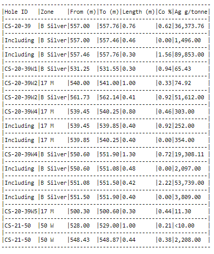
These reported zones are separate from the Robinson Zone which was the basis of the existing May 2020 resource estimate. The Big Silver and 17M Zones are two different structures believed to be subparallel and are north to north-east trending with the Big Silver discovery hole CS-20-39 intercept located 60m south-east from the Robinson Zone discovery hole CA-11-08. The 50 West vein is another separate structure located 650m west of the Robinson Zone discovery hole CA-11-08.
“With the recent drilling, we have been seeing spectacular silver hits, notably as much as 89,853 g/t silver (almost 9% silver). However, this drill program has been very fruitful on the cobalt side as well. The cobalt grades we have been getting with Big Silver are even higher than our first resource released in May 2020. We believe that cobalt will remain a critical mineral in the future because of its role in creating high-range EV batteries, and we are in the process of ramping up our activities to capitalize on cobalt and our proprietary Re-2Ox extraction process in the coming years,” said Matt Halliday, P.Geo., President, and COO.
Cobalt Activities
Cobalt demand has increased in recent years due to its use in batteries for the expanding electric vehicle sector. Research firm Roskill in a recent report forecast cobalt demand to grow at a compound annual growth rate (CAGR) of 7% in the period to 2030 – underpinned by the uptake of EVs globally and healthy medium-term demand from portable electronics amid the roll-out of 5G technology ( Cobalt: Roskill’s keynote speech at the 2021 Cobalt Conference — Roskill ).
The Company’s Castle Mine property, which is located within the high-grade cobalt embayment area surrounding the Town of Cobalt, Ontario, puts it in a prime position to capitalize on this trend. In 2018, bench-scale testing at SGS Canada showed that the Company’s proprietary, closed-loop hydrometallurgical Re-2Ox extraction process can produce premium-grade cobalt sulphate (22.6% cobalt sulphate hexahydrate) that meets industry specifications for EV batteries. The process is environmentally compliant and does not need to use a smelting process that is commonly used by cobalt producers and battery recyclers. The Re-2Ox testing, using concentrate from the Castle Mine, demonstrated cobalt, nickel and manganese recoveries of 99%, 81%, and 84% respectively, in addition to removing 99% of the arsenic (news releases May 31 and August 15, 2018).
The Company is continuing with optimization testing of the Re-2Ox process for mined material and recycled batteries and to determine whether it can be used for rare earth extraction. In addition, work is underway at SGS Canada for the design and construction of a Re-2Ox pilot plant. The Company expects that the Re-2Ox process will be an integral part of its production of cobalt and other base metals for the expanding cobalt market.
Resource Update
Ongoing drilling in the Castle East area is geared toward identifying new veins to enable a significant expansion to the existing resource. The program has been very successful as drilling has discovered a total of seven new high-grade silver vein systems including Big Silver, which is even higher-grade than the original discovery Robinson Zone. These seven new vein systems, along with any new ones discovered during the remaining 18,000 meters of the drill program, will help expand the resource estimate that is scheduled for Q1 2022.
The Company’s maiden Resource Estimate (reported in a news release May 28, 2020) identified two panels of what we call the “Robinson Zone” that contains an average silver grade of 8,582 g/t ( 250 oz/ton ) in a combined 27,400 tonnes of material for a total of 7.56 million Inferred ounces of silver. This is using a cut-off grade of 258 g/t AgEq. Please note that mineral resources that are not mineral reserves do not have demonstrated economic viability. Report reference: Rachidi, M. 2020, NI 43-101 Technical Report Mineral Resource Estimate for Castle East, Robinson Zone, Ontario, Canada , with an effective date of May 28, 2020 and a signature date of July 13, 2020.
Location
The Castle Property is situated near the town of Gowganda, within the prolific Silver-Cobalt mining district (also known as the Cobalt Camp) in Ontario, Canada. The property is located 15 km east of Aris Gold Corp’s Juby gold deposit, 30 km due south of Alamos Gold’s Young-Davidson mine, 75 km southwest of Kirkland Lake Gold’s Macassa Complex, and 100 km southeast of new gold discoveries in the Timmins West area.
Qualified Person
The technical information in this news release was prepared under the supervision of Mr. Matthew Halliday, P.Geo., (PGO) VP Exploration of Canada Silver Cobalt Works Inc., a qualified person in accordance with National Instrument 43-101.
About Canada Silver Cobalt Works Inc.
Canada Silver Cobalt Works Inc. recently discovered a major high-grade silver vein system at Castle East located 1.5 km from its 100%-owned, past-producing Castle Mine near Gowganda in the prolific and world-class silver-cobalt mining district of Northern Ontario. This discovery has the highest silver resource grade in the world, with recent drill intercepts of up to 89,853 grams/tonne silver (2,621 oz/ton Ag). A drill program is underway to expand the size of the deposit with an update to the resource estimate scheduled for Q1 2022.
In May 2020, based on a small initial drill program, the Company published the region’s first 43-101 resource estimate that contained a total of 7.56 million ounces of silver in Inferred resources, comprising very high-grade silver (8,582 grams per tonne un-cut or 250.2 oz/ton) in 27,400 tonnes of material from two sections (1A and 1B) of the Castle East Robinson Zone, beginning at a vertical depth of approximately 400 meters. Note that mineral resources that are not mineral reserves do not have demonstrated economic viability. Please refer to Canada Silver Cobalt Works Press Release May 28, 2020, for the resource estimate. Report reference: Rachidi, M. 2020, NI 43-101 Technical Report Mineral Resource Estimate for Castle East, Robinson Zone, Ontario, Canada, with an effective date of May 28, 2020, and a signature date of July 13, 2020.
Canada Silver Cobalt’s flagship silver-cobalt Castle mine and 78 sq. km Castle Property feature strong exploration upside for silver, cobalt, nickel, gold, and copper. With underground access at the fully owned Castle Mine, an exceptional high-grade silver discovery at Castle East, a pilot plant to produce cobalt-rich gravity concentrates on site, a processing facility (TTL Laboratories) in the town of Cobalt, and a proprietary hydrometallurgical process known as Re-2Ox (for the creation of technical-grade cobalt sulphate as well as nickel-manganese-cobalt (NMC) formulations), Canada Silver Cobalt is strategically positioned to become a Canadian leader in the silver-cobalt space.
“Frank J. Basa”
Frank J. Basa, P. Eng.
Chief Executive Officer
For further information, Contact:
Frank J. Basa, P.Eng.
Chief Executive Officer
416-625-2342
- Published in Canada Cobalt Works, Mining, News Home